��ɽ�ֽ�ؿDZ��εķ������Ӵ�ģ��ģ��
����Ȩ������ƽ���Ծ���
(���ϴ�ѧ �����ѧ����Ϣ����ѧԺ �����ѧ�о����ģ����� ��ɳ��410083)
ժҪ��ͨ������Ԫ��ֵģ��ķ��������������Ӵ�ģ��ģ����ѵķ������˶�������GPS�۲���Լ������ɽ�ĵؿ��˶����Σ�̽����ɽ�����������Եؿ����̵Ķ���ѧ���ơ��о������������ɽ�ֽ�ؿ��˶��������ΪNNE��NE���˶��ٶ�������������������С���ڻ�������࣬�ؿǵ��˶�״̬û�д�����䣻��ɽ�ֽ�ؿǹ���Ӧ�����Խ��ϱ���ѹΪ��������Ӧ���������µؿǷ�����֮��Ӧ�Ľ��ϱ������̱��Σ��ܵ�ɽ���ڲ����弸����̬����ѧ���ʲ����Ӱ�죬��ɽ�ĵؿDZ��β������ȣ����ҵؿ����̵��������ڶ���������С�仯���в�Ϊ��N��S������ƫΪNNW������ƫΪNE������ľ��ص�˳ʱ����ת����������ɽ�ļ�ѹǿ����������������������ǿ�����IJ��Եȼ�ѹ�����£���ɽ����ֳ������������IJ����Եؿ����̱���������
�ؼ��ʣ���ɽ���ؿDZ��Σ��Ӵ�ģ�ͣ���ֵģ�⣻�������˶�
��ͼ����ţ�P541 ���ױ�־�룺A ���±�ţ�1672-7207(2011)09-2754-09
Discontinuous contact model to simulate current crustal deformation in Tianshan Mountain
LEI Xian-quan, CHEN Yun-ping, ZHAO Jiong-yang
(Computational Geosciences Research Centre, School of Geosciences and Info-Physics,
Central South University, Changsha 410083, China)
Abstract: The current crustal deformation of the Tianshan Mountain constrained by the GPS observation was analysed through FEA numerical method, using physical contact model to approach the discontinuous motion of faults. And the dynamic mechanism of crustal shortening with differences in the east and west of the Tianshan Mountain was discussed. The results indicate that the present-day crustal moving direction is generally NNE��NE in the Tianshan Mountain, with decrease of the velocity gradually from southwest to north and east. The state of crustal movement doesn��t change abruptly at the two sides of faults. The current crustal tectonic stress field in the Tianshan Mountain is mainly compressed in nearly N��S, resulting in the crust shortening in nearly N��S as well. The crustal deformation of the Tianshan Mountain is not symmetrical influenced by the differences of the geometrical configurations and mechanical properties of the tectonic blocks. The principal direction of crustal shortening is nearly N��S in the middle, deflecting tinily to NNW in the west and NE in the east. Through analysis, it is thought that the clockwise rotation of the Tarim Basin causes the extrusion strength of the basin against the Tianshan Mountain descend gradually from west to east. With this kind of asymmetric extrusion effect charactered by strong-west and weak-east, the characteristic of crustal shortening deformation is that the difference of the deformation measurement decrease gradually from west to east in the Tianshan Mountain.
Key words: Tianshan Mountain; crustal deformation; contact model; numerical modeling; discontinuous motion
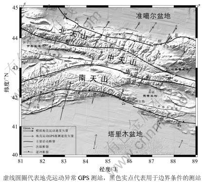
����������Լ50 Ma��ӡ�ȡ�ŷ�ǰ�����ײ���������ϲ������ɽ����ظ�ԭ�����ҵ��������ǵ�����Χ��½�ڱ��Σ��ڴ�½����ڲ��γ���һϵ�о�����ɽϵͳ���й����ڵ�����ľ��ء���ɽ��������ؾ�������һ����Ҫ����ɲ��֡�������ɽ�����������������һЩ��½��Ƭ�͵���ƴ�϶��ɣ�������������ʴ��ƽ���ܵ�ӡ�ȡ�ŷ�ǰ����ײ��Զ�����ã���ɽ�Ĺ����Ա�����ڹ�����ɽ�������Ͽ�ʼ��������ɽ�˶����˺�ؿDz������̡����������γ�������̬(ͼ1)[1-2]����ɽ������������ؿ����̱��ι����У�ɽǰ�ش���ɽ���ڲ��������˴�������������ѣ���������ǿ�ҵĵ�������Ϊ�����������ᡢ���ΰ���ֽ����ڽ�����ɽ���½����ɽ���ĵ��ͣ���ɽ��Ϊ�о���½������Ρ���ɽ��ϻ��ƺ���ɽ����ѧ���������[1-11]�����ż���������ͼ������۷����ķ�չ����ֵģ����Ϊ�о�������ѧ�������Ҫ�ֶΡ����������Ƕ���ɽ�Ĺ�����κͶ���ѧ���������һЩ��ֵģ���о�[12-14]���磺Neil��[12]��������Ԫ�������Ա�Ƭģ��ģ��������ľ��غ���ɽ���ִ��α䳡�������[13]��������Ԫ��������-���ӷ����о����й�������ɽ�ϵ��С�߶ȶ�������ɽ���ã�Qiu��[14]Ӧ������Ԫ��ģ����������ɽ������������ɽϵ�Ļ�����ơ���Щģ��ʵ����˶���ɽ��ɽ������ѧ���������ʶ�������Ƕ�û�п��Ƕ��ѵ����á��ڽ�����ֵʵ��ʱ����δ���������һ���ѵ㡣��ȥ�������������ε���������ģ����ѣ���Ȼ��ijЩ��������ִ�����ʽ������Ϊһ�ֱȽϺ����Ľ��ƣ�����������ʵ���Եط�ӳ���ѵ���ѧ��Ϊ��״̬�����Ų����������Ͳ������������۵����죬�ܹ�ģ����Ѳ������˶��ĽӴ�ģ�ͱ�Խ��Խ���Ӧ����������йصĵ�ѧ�����о� ��[15-17]����ɽ�������ĵؿ����̱��ξ������ԵĶ��������������������ǣ�������ֱ��β����ԭ����ʮ�������Ϊ�ˣ��������߸�����ɽ�ĵ��ʽṹ��������������һ����ά���Ա�Ƭ���ģ�ͣ��Եؿ��˶�GPS�۲��ٶ���Ϊ�߽�Լ��������������ɽ������Ҫ���ѵķ������˶������÷������Ӵ���������ģ����ɽ�ĵؿ��˶����Σ�����ֽ�ؿ��ٶȳ���Ӧ�������α䳡��һЩ�����������ڴ˻����������ɽ��ɽ���ؿDZ��εĶ���ѧģʽ��
1 ģ�ͺͷ���
1.1 ģ�͵Ĺ���
�����ĵ���ģ���DZ�֤ģ����ȷ���ŵ��Ⱦ�����[18]����ɽ�ĵؿ��˶��������������Ĺ��컷��������أ������ڲ����ܱ����漰�����й�������Լ����Ȧ������õĽ�������ڵĵ��ʹ����˶�������ɽ�ڲ����ֳ��������ѷָ�ĸ��ӿ�״�ṹ����ͬ����ĵ��ʽṹ�ͽ����������죬���ڿ�������ض��ѷ�����Ի�������Щ����ɽ�Ĺ�����ξ��м�����Ҫ��Ӱ�죬��ģʱ�����ֿ��ǡ�
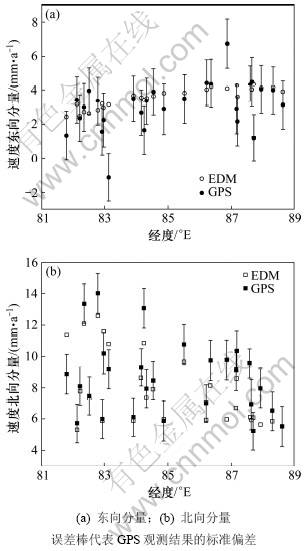
ͼ1 �ؿ��˶�ģ���ٶ���GPS�۲����ĶԱ�
Fig.1 Comparisons between calculated velocities and GPS-measured velocities of crustal movement
�����о���ΧΪ81��~89�� E��40��~45�� N�����������ʼ��ο����ͼ1��ʾ��������ɽ�������ڵ����ĵ��ʽṹ�������[5-9]�����Ĺ�����1����ά���Ա�Ƭģ�ͣ��漰��ɽ�����ϱ�������صIJ��ֵ�������Ȼȷ��������ʯȦ��Ҫ������άģ�ͣ����ǣ���ģ��ؿ��˶�ʱ����ά��Ƭģ�Ϳ��Կ����Ǻ����Ľ��ƣ������⽫��ͼ���ɱ�������ײ��ɽ����������ʯ�����Ա��λ���������������ģ������ڱ����о���������ʯȦdz�㣬ģ��ʱ��Ҳ�̣ܶ���ˣ�����ģ�������õ�[19]��
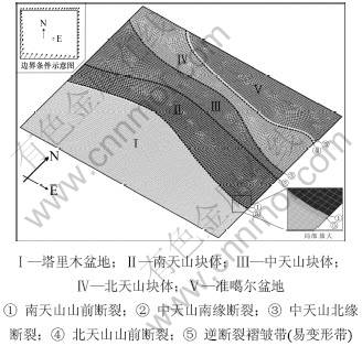
��ɽ���ѹ���ʮ�ַ������������ӡ�Ϊ�������Ч�ʣ��ڱ�֤ģ���ܹ��۷�ӳ����ԭ�͵�ǰ���£���ģ�ͽ�����һЩ������ֻ������Ҫ�Ļ���Ѷ����Խ�С�Ĵμ��ϲ㡣��ɽ�ڲ��Ĺ���ؿ�ʹ��Ͷ��Ѷ��乹���������ҪӰ��[5, 10]����ˣ�����Щ��Ҫ�����Ҳ���ǹ������ķֽ��ߣ��������ܰ���ʵ�ʵ��ʹ����߲������գ���ʹ���������ӽ���ʵ��̬��ģ�Ͱ�������ľ���(����)���������(����)�Լ�����ɽ������ɽ������ɽ��5��������������ɽɽǰ���ѡ�����ɽ��Ե���ѡ�����ɽ��Ե���ѡ�����ɽɽǰ������4����Ҫ����ѡ�������ɽ��ϲ�λ�����-�������Ϊ��������Щ�����-���������������Ĺ����������������Σ���������ľ��ر�Ե�����������Ե��������1����5~6 km���ױ��δ����������ģ����1��������Ӱ�챾���о��������Ҫ���ض����Ե���Ҫ���صļ���ģ�͡�
����4����Ҫ���������ɽ��ɽ������Ҫ�ֽ���ѣ���Ϊ�������ʯȦ����ʯȦ���ѡ���������ɽɽǰ���Ѻͱ���ɽɽǰ���ѷֱ�������ľ��غ������������ɽ�ķֽ磬����ɽ��Ե���Ѻ�����ɽ��Ե���ѽ���ɽ��ɽ���ָ������ɽ������ɽ�ͱ���ɽ3�����ʿ��塣
���������ױ��δ����õ��������屾������ѧ���������й��о����Ϲ���ȡֵ���ø��Եؿ���ѧ���ʵ�ƽ��ЧӦ���棬��ˣ���ͬ����IJ���������ͬ�����ѱ�����Ϊ�������棬�ԽӴ�����ʽ��ģ������Ӵ���֮���ü���ķ��������С�������ӣ�����ѧ����ͨ������Ӵ��նȡ�����Ӵ��նȺͻ���Ħ�����������塣
����Plane182��ά�Ľڵ�ƽ�浥Ԫ���������������Ԫ���֡��õ�Ԫ���е����ԡ���Ӧ�䡢����κ�Ӧ���ջ����������Ժܺõ�ģ����ʯ���ϵı��Ρ���Ansys������Զ��������������˹��ֶ��������ϣ���ʹ����������״�������ܶȺ��ʡ��ֲ����ȣ�ȷ��������нϸߵľ��Ⱥͽ�ǿ���ȶ��ԡ��������������ģ������11 493���ı��ε�Ԫ��12 166���ڵ㡣����Conta175��Ԫ��Targe169��Ԫ������Ѳ������棬ǰ����2D/3D��-��Ӵ���Ԫ����������Ӵ��棻������2DĿ�굥Ԫ������������Ӵ�������ϵ��Ŀ���档������һ��Ŀ���߽�ڵ㶨��Ϊ�Ӵ���Ԫ��ͬʱ������һ��Ŀ���߽�ڵ�������Ŀ�굥Ԫ���Ӵ���Ԫ�����Ӧ��Ŀ�굥Ԫͨ������ʵ������ɽӴ��ԡ���������������Ҫ���ѵĽӴ������ֱ�Ϊ137��113��117��91�������������Ԫ����ģ����ͼ2��ʾ��
ͼ2 ����Ԫģ�ͼ��߽�����ʾ��ͼ
Fig.2 Finite element model of study region and schematic diagram of boundary conditions
1.2 ���Ʒ���
��ɽ�ؿǵ��˶�����������ɽ���ܱ߸���������ڲ���֮���������������ϵ�ġ�����ģ��ʱ��߶ȶ��ҵؿ��˶��ٶ�С�����ι��̻��������ȶ�״̬����ˣ����Զ���ѧЧӦ����ģ�ͼ�Ϊ����ѧ���⣬������̬�ṹ�������м��㡣ģ����ѭ������ѧƽ�ⷽ�̣�
 (1)
(1)
ʽ�У� ΪӦ��������ƫ������fiΪ������
������屻��Ϊ���������壬����Ӧ��-Ӧ���ϵ�ı�������Ϊ��
 (2)
(2)
ʽ�У� ΪӦ��������
 ΪӦ��������
 Ϊ��Ӧ�䣻
 ��
�� Ϊ��÷ϵ����
 ΪKronecker���ţ���i=j����=1����i��j����=0��
 ��
�� ��E��
��E�� �ֱ�Ϊ����ģ���Ͳ��ɱȡ�
�������֮�����������ͨ�����ѵĽӴ�ЧӦ���д��ݣ����������Ӵ���ģ��ϲ������DZ���ģ�͵ĺ��ġ��Ӵ�Ӧ����������Ӵ�Ӧ��(��ѹ��)������Ӵ�Ӧ��(Ħ����)������Ħ����Ħ��ǿ����Ӵ��滬�������صļ���Ħ���������������Ӵ���Ļ���Ħ������������ߵ���Ի������ʵı仯���ı䡣�Ӵ�Ӧ���ļ��㷽�����£�
 (3)
(3)
 (4)
(4)
 (5)
(5)
ʽ�У�fnΪ����Ӵ�Ӧ����ftΪ����Ӵ�Ӧ���� Ϊ���ػ���Ħ��Ӧ����KnΪ����Ӵ��նȣ�KtΪ����Ӵ��նȣ�
 Ϊ����Ħ��������gΪ�Ӵ���Ԫ��Ŀ�굥Ԫ�ĽӴ�������
 Ϊ�Ӵ���Ԫ��Ŀ�굥Ԫ�����Ƶĵ��Է������֡�
2 ���ݺͼ���
2.1 GPS���ݼ��߽�����
�ҹ���20����90�����ʼ����GPS�۲�����IJ��裬�����о��й���½�ĵؿ��˶���ԭʼ��¼���ݾ�����վ�����������н��㣬�õ���վ����ڸ����ο���ܵ�λ���ٶȡ�Ϊ��ʹģ���������ܿ۵ط�ӳ�ؿ��˶�ʵ�������������ÿɿ��Ĺ۲����ݡ����Ĵ�Yang��[20]������GPS�۲�����ѡ���о���Χ�漰��36����������ģ�ͼ��㡣��Щ���ݾ��Ƚϸߣ����ֲ�վ�ٶȵĶ�������ͱ�������IJ�ȷ����Ϊ1~2 mm/a��
GPS�۲��ʾ����ɽ���ܱ��ֽ�ؿ��˶�״̬���ɲ��ֵ�Ϊ�õ����ؿDZ���ģʽ���о��ṩ��Ч���˶�ѧ�߽����������Ľ�������ģ����߽��GPS��վ�ĵؿ��˶��۲��ٶ���Ϊ��֮��ӽ���ģ�ͱ߽�ڵ��Լ��������ͬʱ����Щ���ݽ��ж���Langrage��ֵ����Ϊģ�ͱ߽�������ڵ��Լ����������ͼ2��ʾ�ı߽�����ʾ��ͼ����ѡ�������߽�������GPS�۲�����ʱ������ѡȡ����ģ�ͱ߽�Ͻ��IJ�վ����ԭ�����ܹ������ٵ����ݷ�ӳģ�ͱ߽�����ʵ�ĵؿ��˶�״̬��Ϊ�˹�ѡ��6����վ�����������߽���������ֵ֮���ܹ������۵ط�ӳģ�����ܵ��˶�ѧ��������Щ��վ��ͼ1���ú�ɫʵ���ǡ�
ģ���ڲ����˽Ӵ��ԶԶ��ѵ���ȻԼ���⣬�����ڵ�δ�����κ�Լ��������
2.2 ģ�Ͳ����ͼ������
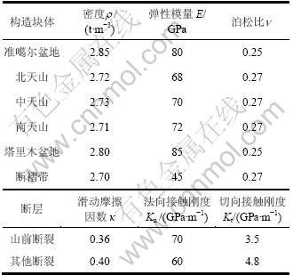
ȷ����ʯ��ѧ������Ӧͨ��ʵ���ã������ڲ�ͬ��������ͬʱ������ͬ�����ʯ�����ʶ�������ͬ��ͬʱ���ܵ��о����������������ƣ���ˣ�ģ�͵��ܶȡ�����ģ�������ɱȺ�Ħ�������Ȳ���ֻ�ܲο�����ѧ����������ѧ�͵���ѧ���о����Ϻ��������ȡֵ[7, 15, 21-22]��
�Ӵ���һ�ָ߶ȷ�������Ϊ���Ӵ��ն��ǽӴ�ģ�͵���Ҫ���������еĽӴ����ⶼ��Ҫ����Ӵ��նȡ��ԽӴ�Ӧ�����м���ʱ����2����Ӵ���֮��Ĵ���ԽС����Խ�ӽ�ʵ���������Ϊ��2�����ڿռ����DZ������ܽ����ġ�����ȡ���ڷ���Ӵ��նȣ�������ն�Խ����Ӵ���ԽС�������ϣ�������ն������ʱ������Ϊ0�����ʵ����ȫ�Ӵ������ǣ�����ķ���նȽ����³������������õ������һ����˵����ȷ���Ӵ��ն�ʱ��Ӧȡ�㹻��ķ���ն��Կ��ƽӴ�����С���涨����ͬʱ��Ӧ��ʹ����ն��㹻С���Բ�����������նȾ�����ֲ�̬���Ӷ�ȷ��������������һ������£�����Ӵ��նȱȷ���ն�С1��2����������
�����������ǣ��ڸ����ı߽������£�ͨ�����ϸı�ģ�͵ĽӴ��նȽ��м��㣬�Ի����GPS�۲�����ӽ���ģ�������������ַ����ĶԱȷ��������ñ�1�и�������ѧ��������GPSԼ����ģ�͵��˶��ٶȡ�Ӧ����Ӧ�䡣��Ϊģ�͵ı߽�������GPS�۲��ٶȣ�ģ��������ӳ�ı��ǵؿ�1 a�������˶������������ˣ�ģ�ͽڵ�λ�Ƽ�Ϊ�ؿ��˶��ٶȣ�Ӧ����Ӧ��ֱ��ǵؿ�Ӧ������仯����Ӧ���ʣ����ǵ�������Ҳ�ֱ�����˵ؿǹ���Ӧ����Ӧ����� ����
��1 ����Ԫģ����ѧ����
Table 1 Mechanical parameters of finite element model
3 ���������
3.1 �ؿ��˶�ģ����
�ؿ��˶�ģ���ٶ���GPS�۲����ĶԱ���ͼ1��ʾ����ͼ1���Կ�����ģ���������۵ط�ӳ���о����ؿ��˶���ʵ��״̬��ͼ3��ʾΪģ������GPS �۲����Ķ�������ͱ�����������ԱȽ������ͼ3�ɼ����ֲ�վ��ģ���ٶȶ���GPS�۲�������Χ�ڣ���������ͱ��������۲����������ƫ��ֱ�Ϊ1.33 mm/a��1.43 mm/a����ˣ�ģ�����ǿ��ŵġ�������ɽ�������ݳǡ���˶������3����վ�Ĺ۲����������������Ĺ۲�����ͬ��Ϊ�˱������������������������ڼ������ʱ������
�ؿ��˶�ģ������ʾ����ɽ�ĵؿ��˶������ں���Ͼ��нϺõ�һ���ԣ�������ΪNNE��NE����������������ƫת�����ơ����ϲ��ĵؿ��˶��ٶȽϴ���������������С���ڻ�������࣬�ؿ��˶����ٶȴ�С�ͷ���ı���٣�������Ŀǰ�����Ĺ��컷���£���ɽ�ڲ����������˶�״̬�ڶ����ڿ��ܲ��ᷢ����ı䶯��
3.2 �ؿ�Ӧ��������
�ؿ�Ӧ���ڴ�½������������ż�����Ҫ�����ã�ͬʱҲ�ǵ���Ԥ��͵���Σ�������۵���Ҫ���ݡ�Ϊ�˼�����ģ�͵���Ӧ������ֲ���ͼ4(a)��ʾ�����ڳ�ʼ��Ӧ��������(ģ�͵ĵ��Լ��豣֤�˴����Ŀ����Ժͺ�����)����ˣ�ģ��õ���Ӧ��ֵ�����ǵ�ǰ�ؿ�Ӧ����ʵ��ֵ�����ǹ���Ӧ������仯�������ܻ��ڵ���ģ�͵õ��ĵؿ�Ӧ������仯ֵû��̫��ο����壬����Ϊ�о����������컷�����г����ȶ��ԣ���ˣ�ģ�ͽ�ʾ����Ӧ���ֲ���ɶ��Եط�ӳ��ɽ�ֽ�ؿǹ���Ӧ������������
ͼ3 �ؿ��˶�ģ����(EDM)��GPS�۲��������Ա�
Fig.3 Error comparision of calculated results with GPS-measured results of crustal movement
�����Ͽ�����ɽ�ֽ�ؿǹ���Ӧ���Խ��ϱ���ļ�ѹӦ��Ϊ����������������Ӧ����������Դ�����о����Ҳ�����õ����ؿ�Ӧ�����Խ��ϱ���ѹΪ����[23]��ģ������ʾ����ѹӦ�������ڲ�ͬ������С�仯������ɽ�в�ΪNNE�ӽ�N��S��������������ƫΪNNW��������ƫ���NE������ɽ������ģ��ĵؿ���ѹӦ����������ǿ��Ӧ�������ݽ���ܽӽ�[24]��������Դ���ƽ�P�᷽λ������ȫһ�¡�

ͼ4 ģ�͵���Ӧ���ֲ����о�����Դ���ƽ⼰��ǿ��Ӧ�������ݽ��
Fig.4 Calculated principal stress field, focus mechanism and stress field inversion results of moderately strong earthquakes in study region
3.3 �ؿDZ�������
��ɽ�ĵؿDZ������о���ɽ��ɽ������Ҫ���ݡ�����ģ�͵���Ӧ��ֲ�����ѹӦ������ͼ5��ʾ����ͼ5��֪���ܵ�������Ӧ�����Ŀ��ƣ���ɽ�ֽ�ؿDZ����Խ��ϱ���ѹ������Ϊ����ͬʱ��������������չ���Σ��ؿ���ѹӦ������ɽ�в�ΪNNE��N��S������ƫתΪNNW��������תΪ��NE��
ģ������ʾ����ɽ���ϱ���ѹ�����ε�Ӧ����ԼΪ10-8 /a����������С����ͬһ�����ϣ���ɽ����ѹӦ���ʱ��ϱ�������ص��Դ���ɽǰ�����-���������ѹӦ����Ҳ����ɽ����ص�Ӧ�����Դ������ϱ��ֳ�һ�ֲ����ȵĶ������������ ������
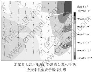
ͼ5 ģ�͵���Ӧ��ֲ�����ѹӦ���ʵ�ֵ��
Fig.5 Calculated principal strain field and contour of principal compressive strain rate
4 ����
ӡ�Ȱ��ij������ϼ�����ŷ�ǰ����ײ�����ļ�ѹ���ÿ����˰�����ɽ���ڵ������й���½������Ӧ���������˶�����ɽ����졢������GPS��ز����о�����������������������������ɽ�Ĺ�����ζ��Գ����Ժ���ѹ������Ϊ���������ҳ��ֳ�����������[2, 5, 20, 25]������ģ������ʾ�����־��ж���������Ľ��ϱ���ؿ���������ɽ�ֽ����ڷ�����
������ɽ�Ĺ�����α���Ϊ��ӡ�Ȱ���ŷ�ǰ�����ײ����֮����Ƽ����ù�ϵ���У�����Щ������Ȼ�������飬�磺�����ڰ��߽�ļ�ѹӦ����δ��ݺ���������ɽ������ظ�ԭ�ֽ����պ��ʣ�������ܷ�����ľ��ز�������ɽ����ǿ�ұ��Σ�������ԭ������ľ�������ɽ���ι������������������õȡ������ĵ�[26-27]ͨ��������ľ��ص���-����ѧ�ṹ�о��������������ʯȦ����Ϊ��ǿ�ȵĸ��Կ��壬��ӡ��-ŷ�ǰ����ײ��Զ��ЧӦӰ�죬����ľ�����Ϊ���Կ������Ӧ�����ݣ�������ɽ����¡����Chen��[3]���ݹŵش�ģ�ͼ���������Ϊ����ľ��ص�˳ʱ����ת(9������)����ɽ������κ͵ؿ����̵�ԭ���������[4]ͨ����ɽ�ϱ���Ҫ����������ͼ���ۺ��о���Ϊ����������ľ��ص�˳ʱ����ת���ܶ���ɽ�Ĺ�����β���Ӱ�죬��������ԭ�����Ƽ�����������Ҫ������Դ����ɽ�����������ı���ͼ����ܾ����ܵ�������ԭ��ǿ���Ƽ����γɵġ�ţ֮����[26]������ɽ�ֽ�ؿ��˶���GPS�۲�����������Ϊ��ɽ�����������β���������������ԭ�ı����Ƽ�(75��E����)������ľ��ص�˳ʱ����ת(75��E�Զ�)��ͬ���õĽ����������û�п��������������ص�����£�������ľ���������ȶ�ŷ�ǰ��ˮƽ�˶���GPS�۲��ٶ���Ϊģ�͵��˶�ѧ�߽�Լ�������ֱ߽���������������ľ��ض���ɽ������ǿ�������ļ�ѹ���ã�ģ��õ��������ѧ������ѧ�ʹ�ز���ѧ�о�������Ǻϵĵؿ��˶�������������ˣ���ɽ���ж�����������ĵؿ����̱�����Ҫ��������ľ��ض���ɽ�IJ��Եȼ�ѹ������ɵġ�����ģ���������Ϸ�������������ɽ�ؿDZ��εĶ���ѧģʽ����ͼ6��
����ľ����������ɽ���˶����Էֽ�Ϊ����ƽ����˳ʱ����ת2���֣�����ǰ��Ϊ����ƽ��������ľ��ش��������ɽ�γɼ�ѹ���ƶ���ɽ�����˶��������ɱ�����ܵ���������ص��赲�������ݵ���ɽ���ϱ���صĹ�ͬЮ����ֻ�ܷ������ϱ���ĵؿ����̣�ʹ����ɽ��Ϊ��Ծ����ɽ�������ͬʱ������ľ��ص���ת����������ɽ�ļ�ѹǿ������������������������ǿ�ҡ����������IJ��Եȼ�ѹ�����£���ɽ�ĺ������̱��α���ֳ��������������������ܵ���ɽ�ڲ�������弸����̬����ѧ���ʲ����Ӱ�죬�ؿ����̵��������ڶ���������С�仯���ں�۹��컷���Ŀ����£���ɽ��Ҫ���ѵ������������ˣ���������ض��ѵIJ������ڵ��ڵؿ�����Ӧ���е��������ޡ�ֵ��ע����ǣ���ɽ�������Ķϲ�����������һ�£�˵����ɽ�ı��γ�������ľ��ص�˳ʱ����ת����֮�⣬������������ľ��ض���ɽ�в����Ƽ�Ш����������һ���Ĺ�ϵ��
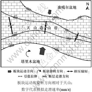
ͼ6 ��ɽ�ؿDZ��ζ���ѧģʽ
Fig.6 Dynamic model of crustal deformation in Tianshan Mountain
5 ����
(1) ��ɽ�ֽ�ؿ��˶��������ΪNNE��NE����������������ƫת�����ƣ��˶��ٶ�������������������С��
(2) �ڻ�������࣬�ؿǵ��˶�״̬û�д�����䣬��������ض��ѵIJ������ڵ��ڵؿ�����Ӧ���е��������ޡ�
(3) ��ɽ�ֽ�ؿǹ���Ӧ�����Խ��ϱ���ѹΪ�����ؿDZ����ڲ�ͬ�������ȣ����ҵؿ����̵��������ڶ���������С�仯���в�Ϊ��N��S������ƫΪNNW������ƫΪNE��
(4) ��ɽ��ɽ�����������Ĺ������������ľ���˳ʱ����ת���õĽ����������ľ��ض���ɽ������ǿ�ҡ����������IJ��Եȼ�ѹ�����£���ɽ�ĺ������̱��α���ֳ�������������������
�ο����ף�
[1] Molnar P, Tapponnier P. Cenozoic tectonics of Asia: effect of a continental Collision[J]. Science, 1975, 189: 419-426.
[2] Chen C, Lu H, Jia D, et al. Closing history of the southern Tianshan oceanic basin, western China: An oblique collisional orogeny [J]. Tectonophysics, 1999, 302(1): 23-40.
[3] Chen Y, Cogne J P, Courtillot V, et al. Paleomagnetic study of Mesozoic continental sediments along the Northern Tianshan (China) and heterogeneous strain in Central Asia[J]. J Geophys Res, 1990, 96: 4065-4082.
[4] ������, ����, ����ƽ, ��. ��ɽ����������������μ��������ѧ����[J]. �й�����, 1996, 12(2): 127-140.
ZHANG Pei-zhen, DENG Qi-dong, YANG Xiao-ping, et al. Late Cenozoic Tectonic deformation and mechanism along the Tianshan Mountain, Northwestern China[J]. Earthquake Research in China, 1996, 12(2): 127-140.
[5] ����, ������, ������, ��. ��ɽ�����[M]. ����: ���������, 2000: 1-415.
DENG Qi-dong, FENG Xian-yue, ZHANG Pei-zhen, et al. Active tectonics in the Tianshan Mountains[M]. Beijing: Earthquake Publishing House, 2000: 1-415.
[6] Ф��, ��ѵ, ����, ��. �½��ϲ��ؿǽṹ�����ݻ�[M]. ����: ����ӡ���, 2004: 1-270.
XIAO Xu-chang, LIU Xun, GAO Rui, et al. Crustal structure and tectonic evolution in southern Xinjiang[M]. Beijing: The Commercial Press, 2004: 1-270.
[7] �Կ���. ��ɽ��ɽ����ʯȦ�ṹ�붯��ѧ[M]. ����: ���������, 2005: 1-251.
ZHAO Jun-meng. Lithospheric structure and dynamic processes of the Tianshan orogenic belt[M]. Beijing: Earthquake Publishing House, 2005: 1-251.
[8] �����, ����, ����Ƽ, ��. ��ɽɽ����ò�������ؿ���ɼ������ݻ�[J]. ����ͨ��, 2006, 25(8): 895-909.
LI Jin-yi, WANG Ke-zhuo, LI Ya-ping, et al. Geomorphological features, crustal composition and geological evolution of the Tianshan Mountains[J]. Geological Bulletin of China, 2006, 25(8): 895-909.
[9] �����, ������, ��־��, ��. �½�����ɽ�������쵥Ԫ���֡��ز�ϵͳ���乹���ݻ�[J]. ��������, 2008, 54(6): 731-750.
ZUO Guo-chao, ZHANG Zuo-heng, WANG Zhi-liang, et al. Tectonic division, stratigraphical system and the evolution of Western Tianshan Mountains, Xinjing[J]. Geological Review, 2008, 54(6): 731-750.
[10] ������, ³�˸�, ����, ��. ��ɽ����ɽǰ������������������������ۻ��[J]. ��ѧǰԵ, 2009, 16(3): 149-159.
CHEN Zheng-le, LU Ke-gai, WANG Guo, et al. Characteristics of the Cenozoic deformation in basin/range coupling regions on both sides of Tianshan Mountains and its geodynamics[J]. Earth Science Frontiers, 2009, 16(3): 149-159.
[11] ����ƽ, ������, ����. ��ɽ��ɽ���Ŀ�Ƶ������̨�������۲�[J]. ��̽����������չ, 2009, 32(1): 27-32.
CHEN Yun-ping, WANG Liang-shu, MI Ning. Broad band digital seismic stations array observations in the Tianshan orogenic belt[J]. Progress in Exploration Geophysics, 2009, 32(1): 27-32.
[12] Neil E A, Houseman G A. Geodynamics of the Tarim and the Tian Shan in central Asia[J]. Tectonics, 1997, 16(4): 571-584.
[13] ����, ����Ԫ, ���, ��. �й�������ɽ�ϵ��С�߶ȶ�������ɽ����[J]. �й���ѧD��, 2007, 37(6): 728-735.
LIU Jie, LIU Qi-yuan, GUO Biao, et al. Small-scale convection in upper mantle beneath the Chinese Tianshan Mountains[J]. Science in China: series D, 2007, 37(6): 728-735.
[14] QIU Zhu-li, LI Hai-bing, PEI Jun-ling. Digital simulation on convergence tendency between southwest Tianshan and Pamirs-West Kunlun systems and its significance[J]. Journal of Earth Science, 2009, 20(2): 417-429.
[15] ֣��, ���J, ����ɺ, ��. Ӧ�÷�����ģ��ģ��ϲ�����ظ�ԭӦ��Ӧ�䳡��Ӱ��[J]. ��������ѧ��, 2007, 50(5): 1398-1408.
ZHENG Yong, CHEN Yong, FU Rong-shan, et al. Simulation of the effects of faults movement on stress and deformation fields of Tibetan Plateau by discontinuous movement models[J]. Chinese Journal of Geophysics, 2007, 50(5): 1398-1408.
[16] Ѧ��̍, ����ɺ, �ַ�. ���������ϲ��Ե�ģ��[J]. ��������ѧ��, 2009, 52(10): 2509-2518.
XUE Ting-xiao, FU Rong-shan, LIN Feng. The simulation of activities of bend fault[J]. Chinese J Geophys, 2009, 52(10): 2509-2518.
[17] ����Ȩ, ����ƽ. Ӧ�÷�����ģ���о��ϲ�Եؿ�Ӧ����Ӱ��[J]. ���ϴ�ѧѧ��: ��Ȼ��ѧ��, 2011, 42(8): 2379-2386.
LEI Xian-quan, CHEN Yun-ping. Research on the effects of faults on crustal stress applying discontinuous kinematic model[J]. Journal of Central South University: Science and Technology, 2011, 42(8): 2379-2386.
[18] Zhao C, Hobbs B E, Ord A. Fundamentals of computational Geoscience-Numerical methods and algorithms[M]. Berlin: Springer, 2009: 1-225.
[19] Turcotte D L, Schubert G. Geodynamics(second edition)[M]. Cambridge: Cambridge University Press, 2002: 1-456.
[20] YANG Shao-min, LI Jie, WANG Qi. The deformation pattern and fault rate in Mountains inferred from GPS observations[J]. Science in China(series D): Earth Science, 2008, 51(8): 1064-1080.
[21] ����. ��ɽ�ؿ��ϵ�ṹ�о�����Ƶ������̨��۲�ͽ��պ�������[D]. �Ͼ�: �Ͼ���ѧ�����ѧϵ, 2005: 1-114.
MI Ning. Crustal and upper mantle structure of the Tianshan[D]. Nanjing: Department of Geosciences, Nanjing University, 2005: 1-114.
[22] �ƽ�ƽ, ����ɺ, ֣��, ��. �������ҷ�����й���½��ʯ����ε�Ӱ��[J]. ��������ѧ��, 2008, 51(4): 1048-1057.
HUANG Jian-ping, FU Rong-shan, ZHENG Yong, et al. The influence of mantle convection to the lithosphere deformation of China mainland[J]. Chinese Journal of Geophysics, 2008, 51(4): 1048-1057.
[23] ����Ӣ, �߹�Ӣ, ������, ��. ����ɽ�ж�����С������Դ���ƽ⼰Ӧ��������[J]. ����, 2008, 28(1): 93-99.
LONG Hai-ying, GAO Guo-ying, NIE Xiao-hong, et al. The focal mechanism solution and stress field inversion of small and moderate earthquakes along middle��eastern part of northern Tianshan Reion[J]. Earthquake, 2008, 28(1): 93-99.
[24] ����Ӣ, �߹�Ӣ, ������, ��. ����ɽ������ǿ������Դ���ƽ����[J]. �й�����, 2008, 24(1): 23-30.
LONG Hai-ying, GAO Guo-ying, NIE Xiao-hong, et al. Focal mechanism solution and stress field inversion of moderately strong earthquake in the Northern Tianshan area[J]. Earthquake Research in China, 2008, 24(1): 23-30.
[25] ţ֮��, ������, ������. ����GPS������ɽ�ֽ�ؿ��α�����[J]. ��ز����������ѧ, 2007, 27(2): 1-9.
NIU Zhi-jun, YOU Xin-zhao, YANG Shao-min. Analysis of contemporary crustal deformation characteristics with GPS data of Tianshan Mountain[J]. Journal of Geodesy and Geodynamics, 2007, 27(2): 1-9.
[26] ������, ������, ���, ��. ����ľ�����ʯȦ��-����ѧ�ṹ��������������[J]. ����ѧ��, 2006, 80(3): 344-350.
LIU Shao-wen, WANG Liang-shu, LI Cheng, et al. Lithospheric thermo-rheological structure and Cenozoic thermal regime in the Tarim basin, Northwest China[J]. Acta Geologica Sinica, 2006, 80(3): 344-350.
[27] ������, ������, ���, ��. ����ľ��Ե��ʯȦ��-����ṹ���������ѧ����[J]. �й���ѧD��, 2003, 33(9): 852-863.
LIU Shao-wen, WANG Liang-shu, LI Cheng, et al. Lithospheric thermo-rheological structure and geodynamic significance in the northern Tarim basin[J]. Science in China: Series D, 2003, 33(9): 852-863.
(�༭ �²ӻ�)
�ո����ڣ�2010-09-18�������ڣ�2010-11-28
������Ŀ���ߵ�ѧУ��ʿѧ�Ƶ�ר����л���������Ŀ(200805331115)������ʡ�о������д�����Ŀ(CX2010B051)��������Ȼ��ѧ����������Ŀ(40874048)
ͨ�����ߣ�����ƽ(1970-)���У������ֶ��ˣ������ڣ����¼�������ѧ��������ѧ����ʯ��ѧ���о����绰��0731-88877077��E-mail: chyp@csu.edu.cn

