基于辫状河露头剖面的变差函数分析与模拟
印森林1,吴胜和1,冯文杰1,唐武1,胡张明2,任翔2
(1. 中国石油大学 地球科学学院,北京,102249;
2. 中国石油天然气西部钻探工程公司,新疆 克拉玛依,834000)
摘要:利用露头剖面资料丰富、取样点多、精度高、直观可靠等特点,建立研究区辫状河沉积的地质知识库。在对露头剖面数字化的基础上,利用已有的露头剖面的地质知识库资料进行变差函数的分析。通过分析获得吴官屯剖面辫状河沉积露头不同井距不同微相的变差函数以及相应的水平主变程与垂直变程比值的变化范围;其中,越岸沉积微相变化范围为2.7~42.2、心滩坝微相变化范围为24.6~54.8、辫状河道微相变化范围为8.9~15.5。结果表明:工区内越岸沉积微相主要是厚层状和薄条带状为主,心滩坝以厚层状为主,而辫状河道以窄厚状为主且规模相对其他微相较小。利用设置的剖面井数据应用序贯指示模拟得到对应模拟结果表明:随着条件数据点的增加(3-4-6-11口井),模拟剖面与数字化剖面的吻合度逐渐增加,分别约为35%,50%,65%和75%;结果说明随着井距逐渐减小时,随机模拟结果与露头剖面逐步接近,模拟结果的不确定性逐渐降低。最后,通过不同井距的变差函数参数表与储层地质知识库数据表对比分析发现,沉积微相的变差函数与地质知识库的变化范围基本一致。这进一步证实在地质建模过程中,利用相似区露头建立详细的地质知识库指导建立地下地质模型是可靠和可信的。
关键词:变差函数;辫状河露头剖面;随机模拟;吴官屯;地质知识库
中图分类号:P618.13 文献标志码:A 文章编号:1672-7207(2013)12-4988-07
Variogram analysis and simulation on sedimentary outcrop profile of braided river
YIN Senlin1, WU Shenghe1, FENG Wenjie1, TANG Wu1, HU Zhangming2, REN Xiang2
(1. College of Geosciences, China University of Petroleum, Beijing 102249, China;
2. Xibu Drilling Engineering Company of PetroChina Karamay, Karamay 834000, China)
Abstract: Based on abundant sampling points, high resolution and direct observation of braided river outcrop data, the geological database of study area was establishesd. On the basis of digital outcrop profile, the geological database was applied to analyze variogram. The results show the followings: Firstly, the different microfacies variograms and corresponeding ratios extent of horizontal major range to vertical range are obtained from different well spaces of Wuguantun braided river outcrop, among which the ratio of overbank(OB) microfacies ranges from 2.7 to 42.2, while channel bar(CHB) microfacies are from 24.6 to 54.8 and braided channel(CH) microfacies are from 8.9 to 15.5. The results demonstrate that the sedimentary microfacies in the overbank of study area mainly show thick layer and thin strip shape, and the channel bars exhibit a thick layer shape, while the braided channel is relative smaller than other microfacies in shape of narrow thick. Secondly, the results gained by applying profile well data and sequential indicator simulation algorithm show that along with the condition data points increasing from 3 to 11, that simulation model is more consistent with the digital outcrop profile with coincidence degree changing from 35% to 75%. Comparing the variogram parameter table of different well spaces experiments with outcrop geologic database, it is found spaces reduced, random simulation results are closer to the outcrop profile, with uncertainty decreased. It is concluded that the variogram parameter of sedimentary microfacies is essentially coincided with the range of geological database, which furtherly confirms that using a similar outcrop to build detailed geological database to guide establishing underground geologic model is reliable and credible.
Key words: variogram; braided river sedimentary outcrop profile; stochastic simulation; Wuguan Tun; geological database
随着油田勘探开发的日益深入,利用野外露头、现代沉积、地下密井网资料和物理模拟实验等建立的原型模型指导三维地质建模的研究得到了广泛的应用。张昌民等[1-3]对青海油砂山油田分流河道砂体的成因、形态、规模及叠置关系进行了研究,并建立了青海油砂山分流河道储层地质知识库。于兴河等[2-5]对大同晋华宫辫状河进行了详细的解剖,对剖面岩石相组合及构型层次界面、储层及非均质特征进行了研究,并依据地质模式建立了晋华宫辫状河储层的三维地质模型;国外最有代表性的是BP公司进行的Gypsy剖面研究和约克逊剖面的露头详细研究,并进行注水开发研究[6]。吴胜和等[7]利用深底沟露头资料建立了新疆克拉玛依冲积扇不同级次构型展布特征,并建立了冲积扇构型模式。薛培华[8]对现代拒马河沉积进行考察,建立了点坝相侧积模式。张春生等[9]利用室内水槽模拟了河流沙丘及砂质扇三角洲形成过程。贾爱林等[9-10]对滦平扇三角洲进行了沉积模拟,研究了不同井距对沉积模拟过程的影响,并利用多种模拟方法试运算,找到了最佳模拟方法。野外露头剖面具有资料丰富、采样点密和资料精度高的特点,可以清晰地观察和描述沉积单元的叠置关系、规模及隔夹层的分布等。野外露头的解剖研究逐步成为油气田开发地质工作者研究的热点。辫状河沉积物在河流相中占有重要的地位。我国中、新生代陆相含油气盆地中,发现了大量的河流相砂体;河流相砂体的石油储量总体上占这些盆地目前探明的储量的46%左右,几乎成为各类碎屑岩之首。所以,对辫状河沉积储层特征进行研究具有重大的理论和实践意义[4]。已有对露头的研究主要集中在建立不同类型的储层地质知识库为目的,为指导建立地下三维地质模型提供原型模型。然而,对辫状河沉积露头进行详细地质分析并探讨辫状河露头剖面的地质统计学变差函数规律的研究较少。本文作者拟对吴官屯辫状河露头建立地质知识库并探讨露头剖面地质统计学变差函数规律。
1 变差函数与序贯指示模拟
1.1 变差函数基本原理及公式
变差函数是地质统计学的基本工具,利用变差函数表征地质体空间相关性是经典随机建模的基础。变差函数为区域化变量的增量平方的数学期望,也就是区域化变量的增量的方差[11-13]。一维变差函数的定义:设Z(x)为定义在一维轴X上的一个区域化变量,Z(X)和Z(X+h)分别为Z(X)在X和X+h处的取值,则Z(X)在X轴方向上的变差函数可以记为:
 (1)
(1)
在平稳假设的前提下,区域化变量Z(x)的期望相等,即有下式成立。
 (2)
(2)
在本证假设条件下,E[Z(X)-Z(X+h)]2仅依赖于分割它们的距离h及方向α。而与所考虑的点X在研究区的位置无关。由此可得,在连续性条件下的变差函数
 (3)
(3)
实际工作中,样品的数目总是有限的,把有限样品值构成的变差函数称为实验变差函数,记为γ*(h),它是γ(h)的估计值。实验变差函数公式:
 (4)
(4)
式中:N(h)为容差范围内相距h的数据点对总数。
1.2 序贯指示模拟随机模拟
1.2.1 指示克里金
针对非参数和无分布的区域化变量Journel[14]提出一种克里格法。它可以在不必去掉重要而实际存在高值数据的条件下,处理各种不同的现象,而且给出一定风险条件下未知量Z(x)的估计量及空间分布。指示克里格提供给定承载的空间估计,认为承载可以看为点承载,从而用于估计的指示数据可以用一阶梯函数表示,即
 (5)
(5)
式中:Z为任一有意义的边界值;i(x,Z)为随机函数。
根据式(4),指示变差函数为:
 (6)
(6)
1.2.2 序贯指示模拟
序贯指示模拟方法是随机建模中广泛应用的方法。该方法中,不要求对条件分布的参数形式做任何假设,在现有数据和其他相关资料的基础上,根据门槛值将条件数据转化为指示数据。根据相应的指示变差函数,应用简单指示克里金给出每个网格节点处条件分布的估计量。序贯指示的主要优点在于:(1) 数据条件化是模拟的一个整体部分,无需作为一个单独的步骤进行处理。(2) 变量的分布形态无需做任何假设。(3) 协方差函数或变差函数不限定于某些特殊类型。(4) 能综合“软信息”。序贯指示模拟方法的步骤:(1) 随机地选择一个还没有模拟值的网格节点。(2) 利用指示克里金估计该处的局部条件概率分布(LCPD)。(3) 从局部条件概率中随机地抽取一个数值。(4) 已模拟的网格节点也作为条件化数据。(5) 重复步骤(1)~(4),直到所有的网格节点都有一个模拟值为止。
2 数据准备
2.1 工区概况
本文研究的吴官屯辫状河露头剖面地处山西省大同市郊,旅游胜地云冈石窟附近,出露地层为侏罗系中统云冈组。出露的中侏罗统云冈组地层产状较为平缓,倾角为4°~8°,最大为10°。辫状河沉积物源来自北部,距离物源较近,平均古流向187°[15]。云冈组自下而上可划分为砂砾岩段、石窟段和砂泥岩段等3段,其中砂砾岩段无出露连续的剖面,石窟段和砂泥岩段有多条人工干预开凿的连续性好的剖面。2009年因修建309公路才出露的吴官屯剖面砂体属于砂泥岩段,吴官屯剖面长约为240 m(本文选取最有代表性的125 m),出露最大可视厚度约为13 m,走向北东―南西向,与古水流斜交,如图1所示。
2.2 吴官屯露头辫状河沉积地质知识库
储层地质知识库就是通过对研究目标的沉积成因、沉积规模、空间形态和展布规律等的总结认识和储层单井模型的统计分析,建立表征储层特征的地质知识。这些知识或直接作为输入参数参与储层随机建模,或为选择随机模拟方法及选择随机模拟实现提供地质依据、或作为模拟结果的精度分析提供对比数据及地质依据;不同的随机建模方法,对地质知识库内容的侧重点有不同要求[16]。
2.2.1 沉积地质体成因
吴官屯剖面整体是一套辫状河沉积露头剖面,发育沉积微相主要有越岸沉积、心滩坝和辫状河道等3种,其中天然堤、决口扇和决口水道等沉积微相不发育。不同期次的辫状河之间具有较为稳定的越岸沉积;同时,部分心滩坝内部发育较稳定的落淤层;辫状河道发育有泥质河道充填、泥质河道半充填和砂质河道充填等3种类型。
2.2.2 沉积地质体岩石相类型
通过对剖面的观测,剖面总体岩性以中-粗砂岩为主,局部含少量细砾岩,剖面西部以块状和低角度的板状交错层理最常见,剖面中部和东部则以板状层理为主,局部可见槽状交错层理和平行层理以及波状层理等。常发育有不同级次冲刷面,可见细砾岩、泥砾等。根据Miall[17]的岩相划分标准和划分方案,依据颜色、岩性、粒度和沉积构造等识别标志,在吴官屯剖面共识别出11种岩相。
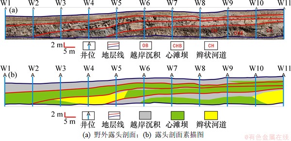
图1 吴官屯露头剖面图
Fig. 1 WuguanTun outcrop profile
2.2.3 沉积微相剖面几何形态
剖面地质体几何形态是识别沉积微相及判断古沉积环境重要依据。越岸沉积以较为稳定发育的泥岩为主,厚度为0.2~0.5 m。心滩坝主要呈现顶凸底平及侧向加积叠置2种形态,厚度1~4 m。辫状河道的形态主要为顶平底凸的形态,其中河道有下切现象,厚度1~3 m。
2.2.4 沉积地质体规模
通过对吴官屯剖面的分析与描述并参考前人研究成果建立了不同沉积地质体的储层地质知识库,如表2所示。
2.3 数据准备
井数据:研究中设计了过剖面井11口(W1~W11),为方便模拟,新增加了9口虚拟井(W12~W20),共20口井,如图1所示。井坐标的相对位置与实际剖面一致。设计井深设为20 m,井距为12.5 m,网格Ix方向88,网格Jy方向41,Kz方向65;△x,△y和△z分别为2,2和0.33 m。剖面网格2 665个。三维网格234 520个。分层数据:根据剖面进行单井等时地层对比分4层。沉积相数据:根据辫状河沉积特点结合模拟的实际情况,主要分为辫状河道、心滩和越岸沉积等沉积微相,按单井剖面进行对比划分。层面数据:利用设定虚拟井位与露头剖面上的井位插值生成层面。
3 随机模拟与结果分析
3.1 模拟步骤
利用已有的地质知识库的认识,结合井点进行变差函数分析模拟。模拟选择序贯指示模拟方法对剖面进行模拟。模拟实验步骤:(1) 资料收集处理:前人研究成果、露头剖面岩石相组合、沉积微相识别及素描剖面图;(2) 数据准备:井坐标数据、分层数据、单井沉积微相露头剖面数据等;(3) 实验方案设计及变差函数分析;(4) 选定过剖面11口井、6口井、4口井与3口井进行变差函数模拟;(5) 模拟结果对比分析。
表1 大同地区中侏罗统云冈组上段吴官屯剖面岩相类型
Table 1 Lithofacies types and of Wuguan Tun in Yungang, Datong
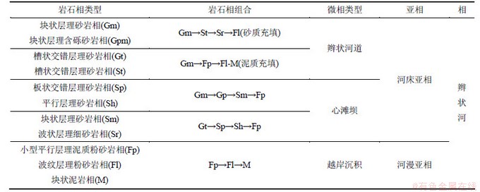
表2 吴官屯剖面沉积微相地质知识库
Table 2 Sedimentary microfacies geological knowledge database of WuguanTun
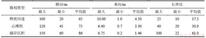

图2 不同井距不同微相变差函数
Fig. 2 Different well spaces and different microfacies variogram
3.2 变差函数分析与模拟
利用地质统计学的重要工具变差函数结合野外露头剖面地质知识库进行剖面模拟的过程中,确定适合工区的实验变差函数的参数值非常重要。
变差函数中具有决定性作用的几个特征值反映了储层参数的空间变化特征,如变程反映了区域化变量的相关范围。在变程范围内,区域化变量具空间相关性;在变程范围外,区域化变量不再有空间相关性,变程不仅反映区域化变量的影响范围,还能直接反映储层参数沿某个方向的变化速度,同时还能从总体上反映出区域化变量的载体(如沉积微相)在某个方向上的平均尺度。利用变差函数提供的全部结构信息,来分析和认识所研究的地质问题。变差函数的理论模型主要有球状模型、指数函数模型、幂函数模型、对数函数模型等。球状模型应用较为广泛,本文选用球状模型进行拟合。利用实际地质知识库分析变差函数对11口井、6口井、4口井和3口井进行序贯指示模拟。剖面模拟的变差函数参数如表3所示;变差函数如图2所示;模拟结果如图3所示。
3.3 模拟结果对比分析
图3所示为不同井距沉积微相序贯指示模拟结果。由图3(a)可见:利用11口井进行的实验变差函数进行模拟,井距为12.5 m;模拟结果与真实剖面的形态相似度极高,且反映了因资料不完备与真实剖面的部分差异性。由图3(b)可见:利用6口井进行变差函数模拟,井距为25 m;在井数据减少的条件下,变差函数参数值发生变化,越岸沉积、心滩坝和辫状河道主变程均减小,图中显示井间不确定性增强。由图3(c)可见:井距为37.5 m;利用4口井进行变差函数模拟;随着越岸沉积与辫状河道主变程减小,模拟结果与真实剖面相差较大,随机性进一步增强。由图3(d)可见:井距为62 m;利用3口井进行实验变差函数模拟,模拟结果与真实剖面相差甚大。说明随着井点数据的进一步减小,即井距进一步增大,变差函数中数据样本点对减少,模拟结果随机性进一步增强,不确定性进一步加大,结果与真实剖面相差越来越大。
表3 实验变差函数参数
Table 3 Experiment variogram parameter
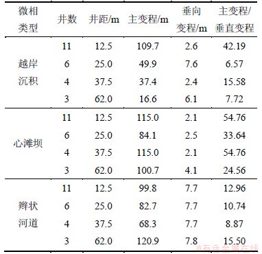
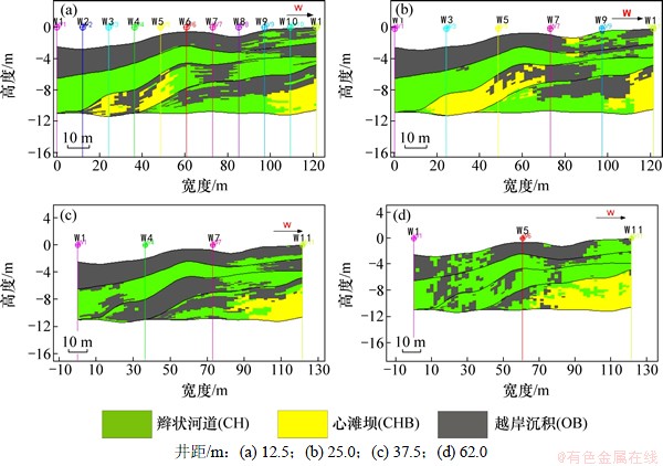
图3 不同井距沉积微相序贯指示模拟实现
Fig. 3 Sequential indicator simulation different well spaces microfacies
4 结论
(1) 获得了吴官屯剖面辫状河沉积露头不同井距不同微相的变差函数以及相应的水平主变程与垂直变程比值的变化范围;其中,越岸沉积微相变化范围2.7~42.2、心滩坝微相变化范围24.6~54.8、辫状河道微相变化范围8.9~15.5。水平主变程与垂直变程的比值反映了沉积体的沉积特点,越岸沉积泥岩比值变化较大,反映了纵向不同位置越岸沉积泥岩的沉积体厚薄与长宽比差异较大,体现了越岸沉积的厚层状与薄条带状的分布形态;心滩坝变化范围较小,表明心滩坝沉积体的厚薄和长宽比变化范围较小,体现了心滩的厚层状形态;同时,心滩坝规模较河道和越岸沉积大;辫状河道变化范围小,且比值较小,体现了工区发育的辫状河道规模差异小,以窄厚状为主,也说明辫状河道相对心滩坝、越岸沉积体来说规模较小。
(2) 利用设置的剖面井数据应用序贯指示模拟得到对应模拟结果表明,随着条件数据点的增加(3-4-6-11口井),模拟剖面与数字化剖面的吻合度逐渐增加,分别约为35%,50%,65%和75%;结果说明随着井距逐渐减小,随机模拟结果与露头剖面逐步接近,模拟结果的随机性降低。
(3) 通过不同井距的变差函数参数表与储层地质知识库数据表对比分析发现,不同沉积微相的变差函数与地质知识库的数据变化范围基本一致。这进一步证实了在地质建模过程中,利用相似区露头建立详细的地质知识库指导建立地下地质模型是可靠和可信的。
参考文献:
[1] 张昌民, 徐龙, 林克湘, 等. 青海油砂山油田第68层分流河道砂体解剖学[J]. 沉积学报, 1996, 14(4): 71-77.
ZHANG Changmin, XU Long, LIN Kexiang, et al. Anatomy of distributary channel sand, the No.68 sandbody of Youshashan, Western Qinghai[J]. Sedimentologica Sinica, 1996, 14(4): 71-77.
[2] 林克湘, 张昌民, 刘怀波, 等. 青海油砂山油田迷宫式分流河道砂体地质模型的建立[J]. 石油与天然气地质, 1995(2): 98-109.
LIN Kexiang, ZHANG Changmin, LIU Huaibo, et al. Establishment of geological model for labyrinth diffluence channel sand bodies in Youshashan Oilfield,Qinghai[J]. Oil & Gas Geology, 1995(2): 98-109.
[3] 雷卞军, 张昌民, 林克湘, 等. 定量储层沉积学是获取储层建模地质信息的重要途径―以青海省油砂山露头研究为例[J]. 石油实验地质, 1998, 20(1): 61-67.
LEI Bianjun, ZHANG Changmin, LIN Kexiang, et al. Quantitative reservoir sedimentology as an important way to obtain geological informatin for reservoir model establishment: A case study on the outcrop of Youshashan in Qinghai Province[J]. Experimental Petroleum Geology, 1998, 20(1): 61-67.
[4] 于兴河, 马兴祥, 穆龙新, 等. 辫状河储层地质模式及层次界面分析[M]. 北京: 石油工业出版社, 2004: 60-106.
YU Xinghe, MA Xingxiang, MU Longxin, et al. Analysis of hierarchy bounding surfaces and geological pattern of braided reservoir[M]. Beijing: Petroleum Industry Press, 2004: 60-106.
[5] 于兴河, 李胜利. 碎屑岩系油气储层沉积学的发展历程与热点问题思考[J]. 沉积学报, 2009, 27(5): 880-893.
YU Xinghe, LI Shengli. The development and hotspot problems of clastic petroleum reservoir sedimentology[J]. Acta Sedimentologica Sinica, 2009, 27(5): 880-893.
[6] 吴胜和, 范峥, 许长福, 等. 新疆克拉玛依油田三叠系克下组冲积扇内部构型[J]. 古地理学报, 2012, 14(3): 331-340.
WU Shenghe, FAN Zheng, XU Changfu, et al. Internal architecture of alluvial fan in the Triassic Lower Karamay Formation in Karamay Oilfield, Xinjiang[J]. Journal of Palaeogeography, 2012, 14(3): 331-340.
[7] 薛培华. 河流点坝相储层模式概论[M]. 北京: 石油工业出版社, 1991: 56-59.
XUE Peihua. An introduction to reservoir models of fluvial point bar facies[M]. Beijing: Petroleum Industry Press, 1991: 56-59.
[8] 张春生, 刘忠保, 施冬, 等. 砂质扇三角洲沉积过程实验研究[J]. 江汉石油学院学报, 2003, 25(2): 1-4.
ZHANG Chunsheng, LIU Zhongbao, SHI Dong, et al. Experimental study of sandy-fan-delta sedimentary process[J]. Journal of Jianghan Petroleum Institute, 2003, 25(2): 1-4.
[9] 贾爱林, 陈亮, 穆龙新, 等. 扇三角洲露头区沉积模拟研究[J]. 石油学报, 2000, 21(4): 107-110.
JIA Ailin, CHEN Liang, MU Longxin, et al. A study on sedimentary simulation of fan-delta outcrop[J]. Acta Petrolei Sinica, 2000, 21(4): 107-110.
[10] 贾爱林, 陈亮, 穆龙新, 等. 扇三角洲露头区沉积模拟研究[J]. 石油学报, 2000, 21 (6): 107-110.
JIA Ailin, CHEN Liang, MU Longxin, et al. A study on sedimentary simulation of fan-delta outcrop[J]. Acta Petrolei Sinica, 2000,21 (6): 107-110.
[11] 吴胜和. 储层表征与建模[M]. 北京: 石油工业出版社, 2010: 303-305.
WU Shenghe. Reservoir characterization and modeling[M]. Beijing: Petroleum Industry Press, 2010: 303-305.
[12] Deutsch C V. Geostatistical Reservoir Modeling, 2002. Applied Geostatistics Series, G., JA, Ed[M]. New York, USA: Oxford University Press, 2002: 20-45.
[13] 周游, 程时清, 张敏. 储层建模中变差函数参数的设置[J]. 西安石油大学学报: 自然科学版, 2010, 25(5): 26-27.
ZHOU You, CHENG Shiqing, ZHANG Min. Setting of variogramparameters in reservoir modeling[J]. Journal of Xi’an Shi You University: Natural Science Edition, 2010, 25(5): 26-27.
[14] Journal A G. Nonparametric estimation of spatial distributions[J]. Journal of the International Association for Mathematical Geology, 1983, 15(3): 793-806.
[15] 王随继. 大同盆地中侏罗世河流沉积体系及古河型演化[J]. 沉积学报, 2001, 19(4): 501-505.
WANG Suiji. Fluvial depositional systems and river pattern evolution of middle jurassic series, Datong Basin[J]. Acta Sedimentologica Sinica, 2001, 19(4): 501-505.
[16] 陈恭洋. 碎屑岩储层随机建模[M]. 北京: 地质出版社, 2000: 158-159.
CHEN Gongyang. Clastic reservoir stochastic modeling[M]. Beijing: Geology Press, 2000: 158-159.
[17] Miall A D. Architectural-element analysis: A new method of facies analysis applied to fluvial deposits[J]. Earth-Science Reviews, 1985, 22(4): 261-308.
(编辑 陈爱华)
收稿日期:2013-03-22;修回日期:2013-06-18
基金项目:国家科技重大专项(2011ZX05030-005-02,2011ZX05009-003)
通信作者:印森林(1983-),男,湖北仙桃人,博士研究生,从事精细油藏描述和储层三维地质建模研究;电话:18810459678;E-mail:yinxiang_love@qq.com

