改进的Mean-Shift遥感影像分割方法
周家香,朱建军,马慧云,梅小明
(中南大学 地球科学与信息物理学院,湖南 长沙,410083)
摘要:基于高斯核Mean-Shift(MS)算法因收敛速度慢难以满足遥感图像处理的实时应用要求,提出一种改进的MS算法应用于遥感图像分割。针对传统MS算法需多次人工试用来确定固定带宽的问题,给出几种类型遥感影像的空间带宽参考值,且不同波段影像用plug-in规则分别计算值域带宽。针对遥感影像数据量大、MS迭代计算时间长的不足,使用一些加速策略来加速收敛;由于采用MS算法检测出的模点数较多,采用基于全局模点融合来稳定遥感影像分割结果;可用于分割遥感影像的特征很多,模点检测时用灰度特征,全局模点融合时用纹理特征,这样充分利用了遥感影像多维特征且不降低计算速度。采用Quickbird影像进行分割试验,研究结果表明:本文算法自适应程度高,速度和精度也能满足应用要求,是一种稳健的自动分割方法。
关键词:mean-shift;遥感影像;分割;带宽;模点检测;模点融合
中图分类号:P22 文献标志码:A 文章编号:1672-7207(2012)02-0620-06
Improved mean-shift segmentation approach for remote sensing images
ZHOU Jia-xiang, ZHU Jian-jun, MA Hui-yun, MEI Xiao-ming
(School of Geosciences and Info-Physics, Central South University, Changsha 410083, China)
Abstract: Due to low convergence speed of Gauss kernel Mean-Shift, it couldn’t satisfy real time application of remote sensing image processing, an improved mean-shift segmentation approach for remote sensing image was proposed. In order to overcome some defects of fixed bandwidths of classic Mean-Shift, referenced spatial bandwidths were given according to the spatial resolution of remote sensing images, and various hue range bandwidths of each band were calculated using plug-in rules. In order to solve the problem of spending much time in Mean-Shift iteration caused by the voluminous imagery data set, some accelerating strategies were proposed. As the number of mode detected by Mean-Shift algorithm were large, global based mode merging method was proposed to stabilize the segmentation result of remote sensing images. Multi-dimension features were used and calculation speed was advanced, color features were used in mode detection and texture features were used in mode merging. Segmentation experiments were processed with Quickbird satellite image. The results show that the presented method is adaptive, and its speed and precision can satisfy application, so it is a robust automatic segmentation algorithm.
Key words: Mean-Shift; remote sensing image; segmentation; bandwidth; mode detection; mode merging
国内外在图像分割方面已取得了很多成果,现有自然图像分割方法可概括为以下几个方面:基于全局信息或局部信息;基于区域或边缘;针对灰度影像或纹理影像[1]。由于遥感影像所记录地物的复杂性和多样性,数据量巨大,将这些分割方法引入到遥感影像分割中面临很大困难[2-3]。Mean-Shift (MS)算法是一种高效的统计迭代算法,依靠特征空间样本点的统计特征,不需要任何先验知识,近年来被广泛地应用于图像分割[4-7]和跟踪[8]等计算机视觉领域。传统MS算法的计算复杂度是O(kdN2) (其中k为每个数据点的平均迭代次数,d为数据维数,N为1幅图像的像素)[9-12],如IKONOS和QuickBird等遥感影像,需要多次迭代才能收敛。同时,若所用的特征向量的维数多,则收敛速度比较慢,影响遥感图像的实际应用。近年来,一些研究者研究了MS算法的原理,提出减少迭代次数和降低每次迭代的计算量这2种提高算法效率的方法[10]。为了提高MS算法对遥感影像分割的速度和效果,本文提出以下改进措施:
(1) 对不同空间分辨率遥感图像给定空间带宽参考值,不同波段采用不同的灰度值域带宽。基于传统MS算法编写的EDISON软件需要人工输入空间带宽和值域带宽,且所有波段采用相同的值域带宽。若将遥感影像分割成有意义的区域且没有过多的细节,自适应带宽才能得到好的分割效果。
(2) 面对大数据量的遥感影像分割速度慢的问题,本文主要在MS运行效率上采取多项加速措施。
(3) 针对MS分割存在过分割现象,将检测出的模点采用基于全局模点融合来得到稳定的分割结果。
(4) 可用于遥感影像分割的特征很多,模点检测或模点融合时利用全部特征势必增加计算时间,改进方法将可将特征分组,利用位置和颜色特征进行模点检测,利用纹理特征进行模点融合。
1 改进MS遥感影像分割算法
1.1 传统高斯MS算法模点检测
传统高斯核MS由高斯核密度估计的梯度推导获得[4]。给定d维欧拉空间R中n个采样点{xi,i=1,…,n},利用高斯核函数 ,则MS迭代向量为:
 (1)
(1)
式中:xs为二维位置特征;xr为多维值域特征;hs为空间带宽;hr为值域带宽。则传统MS计算步骤:
(1) 选用高斯核函数,带宽hs和hr,随机给定样本点x;
(2) 根据式( 1) 计算样本点的迭代向量m(x);
(3) 条件判断,若|m(x)-x|>ε(ε为阈值,如0.001),则移动点x到m(x),执行步骤(2),否则,结束循环;
(4) 将结束循环后的m(x)赋给x,此时m(x)称为样本点x的模点;
(5) 移动到下一样本点x,重复步骤(2)~(4),直至检测出影像内每个数据点的模点为止;
(6) 将收敛至相同模点的数据点归为同一区域,得到初分割结果。
这样,整个影像被分解成m个子区域Sj(j=1,2,…,m),每个子区域像素为nj,中心为cj,则:
 (2)
(2)
1.2 全局模点融合
由于MS分割存在过分割问题,经过MS分割后,将以点阵表示的图像转化为块状表示。然后,采用如下过程的基于区域的MS迭代。
对每一个子区域Sj(j=1,2,…,m),进行以下迭代:
 (3)
(3)
式中:np为区域p的像素;h为带宽;k为迭代次数; 。用上式进行迭代计算,直至
 ≤εw为止(εw是阈值,如0.001),将最终收敛值记录为
 。
。
(2) 对所有 和
和 (1≤a,b≤m,a≠b),若
 ≤εv(εv为阈值,如取h/2),则将块Sa和Sb归为一个区域,否则,Sa和Sb是不同的区域。
1.3 改进的MS遥感影像分割算法实现
1.3.1 滤波
图像噪声会使检测出的局部模点数过多,这样使后面的模点融合变得困难。滤波能降低噪声对模点检测的影响。事实上,MS本身对噪声不太敏感[11],模点检测前的滤波能很好地降低噪声的影响,这样能使模点检测过程更简单。本文选择3×3的中值滤波。
1.3.2 带宽的选择
在MS算法中最重要的参数是带宽矩阵H,它决定迭代速度和分割效果。目前,Plug-in 和Cross-validation是广泛使用带宽选择方法[1]。Plug-in 规则是用估计参数来代替未知参数,渐进积分均方误差是应用于Plug-in规则的通用标准。使渐进积分均方误差最小便可估计全局值域带宽:
 (4)
(4)
式中:d为特征向量维数;j为单个波段;n为数据量;σj为特征向量的标准差。
 (5)
(5)
x为单波段灰度; 为灰度平均值。当d=5时,H=(hx,hy,hR,hG,hB),hs=hx=hy。空间带宽hs决定搜索窗口大小,当hs增大时,参与运算的采样点就越多,计算时间将增加,平滑后图像细节将被忽略。实验结果表明:过大的hs不总是改善分割质量。因此,为了降低计算时间,同时考虑到后面还要进行模点融合,宜采用较小的hs。
在plug-in准则下获得的值域带宽hr=(hR,hG,hB) 能尽可能地降低估计密度函数与原始密度函数之间的变形。为了将遥感影像分割成有意义的区域而不含有过多的细节,一般来说,过小的hr是无意义的。但是,过大的值域带宽导致忽略更多的影像细节,同时降低检测出的模点数;相反,小的灰度带宽使更多的地物细节被提取出来。因此,灰度值域带宽hr被认为是分割的尺度。
1.3.3 快速高斯模点检测
应用传统MS算法进行聚类,可得到初始分割结果。初始分割是对影像中每一个像点进行MS迭代得到其模点,由于遥感影像数据量大,迭代计算量非常大,本文采用以下加速策略。
(1) 以待处理点xs为中心,事先根据图像的空间分辨率来选择空间带宽hs,以长、宽均为2hs+1的正方形按下式构造高斯空间模板;
 (6)
(6)
式中:xs表示待处理点的二维坐标,xsi为以xs为中心,长和宽为2hs+1正方形内的采样点二维坐标。可以看作权值,与xs点近的采样点权值大,远的采样点权值小。则式(1)变成:
 (7)
(7)
(2) 为了减少MS迭代次数,从xn点开始MS迭代,第τ次迭代后的向量为 等于或近似于另一特征向量xm,则认为xn和xm收敛于同一个模点,停止迭代。
(3) 对任意一随机样本点x,沿一定的路径收敛至一固定点(即模点),将收敛路径一定宽度内的点都认为收敛至相同的模点,这些点不再参加迭代计算。
(4) MS迭代计算量大的1个主要原因是特征向量的维数,而遥感图像可用的特征向量的维数很多,本文将特征向量分为2组,首次迭代时使用多光谱灰度特征,模点融合时使用纹理特征。
1.3.4 基于全局的模点融合
由于传统MS分割一般存在过分割现象,进一步将分割后的影像进行全局模点融合,得到最终分割结果。遥感影像的特征有位置、灰度、纹理、形状等,为了达到理想的分割结果,应尽可能地利用遥感影像的多维特征[9],这样势必会增加计算时间。为了充分利用遥感影像的多维特征又不增加计算时间,在模点融合时使用纹理特征。
此时,用到的纹理特征f1,f2和f3分别为:
 (8)
(8)
 (9)
(9)
 (10)
(10)
式中:i和j为像素点灰度值;p(i,j)为灰度值i和j出现的归一化概率;L为灰度级。则式(3)中h应为纹理带宽ht。对任一分割子区域Sj(j=1,2,…,m),其纹理带宽由下式计算:
 (11)
(11)
式中:nj为第j块的像素,fki(k=1,2,3)为该块内像素i的fk纹理特征;ckj(k=1,2,3)为第j块的fk纹理均值。
2 实验结果评价与分析
2.1 分割实验
在改进的分割方法中,空间带宽hs主要影响计算速度。不同传感器的影像有不同的空间分辨率。图1所示为SPOT5影像采用不同空间带宽分割结果的对比。实验发现,空间分辨率为10.00 m的SPOT5影像选用hs=5比较合适,空间分辩率为2.44 m的Quickbird影像选用hs=9比较合适。
图2(a)是1幅Quickbird 影像270×270的子图像,采用前面提出的参考空间带宽hs=9和由式(4)计算的灰度值域带宽进行快速高斯MS迭代得到图2(b)所示的分割结果(290个模点)。图2(c)所示是用EDSION软件(1个基于传统MS算法编写的软件)分割结果。将本文的分割结果与EDISON软件分割结果进行对比,由图2(c)可见:本文分割结果要优于EDISON软件分割结果。

图1 SPOT5影像不同空间带宽对比实验
Fig.1 Contrast experiment of SPOT5 image with various space bandwidths

图2 改进分割方法与EDISON分割结果对比
Fig.2 Comparative segmentation between presented approach and EDISON of Quickbird image
从图2(b)可以看出:本文的分割结果比较理想,但与分割参照图(图3(b))比较还存在过分割现象。对初分割结果进行全局模点融合,保持原有空间带宽不变,采用式(11)计算每块的纹理带宽,得到图3(a)所示的实验结果。由图3(c)可见:本文分割结果比较理想。
2.2 本文改进方法与传统MS算法的时间比较
通过实验比较传统MS方法与本文MS改进方法的算法时间。采用图2(a)所示Quickbird图像,计算时间见表1,从表1可以看出:本文所采用加速策略是有效的。
2.3 分割效果讨论
为了评价分割的效果,本文对图2(a)所示的Quickbird影像进行定量对比实验。Polak等[13]提出了一种基于对象一致性误差(EOC)的客观有效的图像分割评判标准。EOC(Ig,Is)∈[0,1](其中Ig为地面参考对象,Is为实际分割对象)。当EOC=0时,表示分割完全与地面参考对象一致;EOC越小,表示分割效果越好。实验所用图2(a)的研究范围较小,图像空间分辨率较高,且各类地物相对集中,通过目视判读得到实验参考图(图3(b))。将地物分为房屋、林地、水面、农田、绿地以及阴影6类。表2所示为本文方法与EDISON软件分割的EOC,可以看出:采用本文方法所得房屋、林地的分割效果明显优于EDISON的分割效果,水面、农田、绿地和阴影4类地物的分割效果相当。
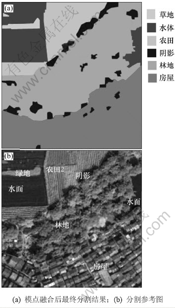
图3 模点融合后分割结果
Fig.3 Segmentation results after mode merging
表1 传统MS与改进MS计算时间比较
Table 1 Comparative time of traditional MS and improved MS s
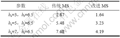
表2 改进分割方法与EDISON分割方法的Eoc对比
Table 2 Comparison of Eoc between presented improved approach and EDISON

3 结论
(1) 对常用的高分辨率遥感影像如SPOT5和Quickbird的MS模点检测的空间带宽的选择给出了参考值,其他的遥感影像根据其空间分辨率参照这2类影像来确定。
(2) 遥感影像不同波段分别用公式计算值域带宽,以实现自适应的MS遥感影像分割。
(3) 模点检测时采用4个有效的加速措施,减少了MS迭代时间;同时,将遥感影像的多维特征分组,模点检测时采用空间特征和多光谱特征,模点全局融合时采用纹理特征,这样加快了MS迭代速度。
(4) 采用基于全局的模点融合提高遥感影像分割精度。用MATLAB实现了本文改进的遥感图像分割方法,实验结果与由传统算法所得结果相比,本文方法具有分割效果好等优点。
参考文献:
[1] HONG Yi-ping, YU Jian-qiang, ZHAO Dong-bin. Improved mean shift segmentation approach for natural images[J]. Applied Mathematics and Computation, 2007, 185(2): 940-952.
[2] van der Sande C J, de Jong S M, de Roo A P J. A segmentation and classification approach of IKONOS-2 imagery for land cover mapping to assist flood risk and flood damage assessment[J]. International Journal of Applied Earth Observation and Geoinformation, 2003, 4: 217-229.
[3] 杨朝云, 陈光儒, 吕嫦艳, 等. 一种改进的高分辨率遥感影像分割方法及应用[J]. 电脑信息技术, 2010, 18(4): 45-48.
YANG Zhao-yun, CHEN Guang-ru, L? Chang-yan, et al. An improved high resolution RS images partition way and its applying[J]. Computer and Information Technology, 2010, 18(4): 45-48.
[4] Comaniciu D, Meer P. Mean-Shift: A robust approach towards feature space analysis[J]. IEEE Transaction on Pattern Analysis and Machine Intelligence, 2002, 24(5): 603-619.
[5] Comaniciu D, Ramesh V, Meer P. The variable bandwidth mean shift and data-driven scale selection[C]//Proceedings of Eighth IEEE International Conference on Computer Vision. Vancouver, United States, 2001: 438-445.
[6] 王兆虎, 刘芳, 焦李成. 一种基于视觉特性的遥感图像分割[J]. 计算机学报, 2005, 28(10): 1687-1691.
WANG Zhao-hu,LIU Fang,JIAO Li-cheng. A remote sensing image segmentation algorithm based on vision information mean shift algorithm accelerated mean shift algorithm[J]. Chinese Journal of Computers, 2005, 28(10): 1687-1691.
[7] Comaniciu D. An algorithm for data-driven bandwidth selection[J]. IEEE Transactions on Pattern Analysis and Machine Intelligence, 2003, 25(2): 281-288.
[8] Comaniciu D, Ramesh V, Meer P. Real-time tracking of non-rigid objects using mean shift[C]//Proceedings of IEEE Conference on Computer Vision and Pattern Recognition. Hilton Head Island, United States, 2000: 142-149.
[9] Georgescu B, Shimshoni I, Meer P. Mean shift based clustering in high dimensions: a texture classification example[C]// Proceedings of IEEE International Conference on Computer Vision. Nice, France, 2003: 456-463.
[10] Carreira-Perpinan M A. Acceleration strategies for Gaussian mean―shift image segmentation[C]//Proceedings of the 2006 IEEE Computer Society Conference on Computer Vision and Pattern Recognition. New York: IEECS Press, 2006: 543-549.
[11] Kaftan J N. Mean shift segmentation evaluation of optimization techniques[C]//International Conference on Computer Vision Theory and Application. Madeira, Portugal, 2008: 365-374.
[12] Carreira-Perpinan M A. Gaussian mean shift is an EM algorithm[J]. IEEE Transactions on Pattern Analysis and Machine Intelligence, 2007, 29(5): 767-776.
[13] Polak M, ZHANG Hong, PI Ming-hong. An evaluation metric for image segmentation of multiple objects[J]. Image and Vision Computing, 2009, 27: 1223-1227.
(编辑 陈灿华)
收稿日期:2011-04-25;修回日期:2011-06-18
基金项目:国家自然科学基金青年科学基金资助项目(40901171);国家高技术研究发展计划(“863”计划)重点资助项目(2009AA122004);武汉大学测绘遥感信息工程国家重点实验室基金资助项目(09R03)
通信作者:周家香(1967-),女,湖北松滋人,博士研究生,从事遥感图像处理等研究;电话:13467547265;E-mail:pf2zjx@163.com

