J. Cent. South Univ. (2016) 23: 2958-2971
DOI: 10.1007/s11771-016-3360-1

Effects of water level fluctuation on sedimentary characteristics and reservoir architecture of a lake, river dominated delta
ZHANG Yang(����)1, QIU Long-wei(��¡ΰ)1, YANG Bao-liang(���)1, LI Ji(���)2, WANG Ye-lei(������)1
1. School of Geosciences, China University of Petroleum, Qingdao 266580, China;
2. Experiment Testing Institute, PetroChina Xinjiang Oilfield Company, Karamay 834000, China
 Central South University Press and Springer-Verlag Berlin Heidelberg 2016
Abstract:
The hydrodynamic conditions present in a river delta��s formation are a highly important factor in the variation between its sedimentary regulation and characteristics. In the case of the lacustrine basin river-dominated delta, water level fluctuations and fluviation, are both important controlling factors of the sedimentary characteristics and reservoir architecture. To discuss the effects of water level fluctuation on sediment characteristics and reservoir architecture of this delta, the Fangniugou section in the east of the Songliao Basin was selected for study. Based on an outcrop investigation of the lacustrine basin river-dominated delta, combining with an analysis of the major and trace chemical elements in the sediments to determine the relative water depth, through architecture bounding surfaces and lithofacies division, sedimentary microfacies recognition and architectural element research, this work illustrated the effects of water level fluctuation on the reservoir architecture and established sedimentary models for the lacustrine basin river-dominated delta under various water level conditions. The results show that there are 8 lithofacies in the Fangniugou section. The fan delta front, which is the main object of this study, develops four sedimentary microfacies that include the underwater distributary channel, river mouth bar, sheet sand and interdistributary bay. The effects of water level fluctuation on different orders geographic architecture elements are respectively reflected in the vertical combination of the composite sand bodies, the plane combination of the single sand bodies, the particle size changes in the vertical of hyperplasia in the single sand body, the coset and lamina. In the case of the sand body development of the petroliferous basin, varying water level conditions and research locations resulted in significant variation in the distribution and combination of the sand bodies in the lacustrine basin.
Key words:
1 Introduction
China is rich in oil and gas resources, which are mainly located in the transition zone where river deltas develop [1]. The lacustrine delta is a standard site for many researchers for the study of sedimentology and as a target for oil and gas exploration. Since the 1980��s, the classification, sedimentary models, reservoir architecture and other aspects of lacustrine deltas have been the subjects of discussion by many scholars [2-17]. The hydrodynamic condition of a delta��s formation is the most important factor in determining the sedimentary characteristics and reservoir architecture. With respect to the lacustrine basin delta, a river-dominated delta is of greatest importance in this process. The form and stacking velocity of the delta are determined by the water supply of river��s source. Most of the river-dominated deltas are reformed to varying degrees by the fluctuation in water levels. The changes in water level and water area result in frequent expansion and contraction of the delta and influence the distribution of the sand body and the reservoir architecture of the delta. Equivalent to fluvial action, water level fluctuation is a significant factor that requires consideration in delta formation. However, early investigators usually considered only the effect of one dimensional factors in delta formation, such as river waves etc., but did not consider the fluctuation of water levels, which is a two dimensional phenomenon. Their conclusions also provided several contradictions concerning river morphology, development of river mouth bar and crevasse splay. SHI and JI [6] established a sedimentary model for a fan delta. In this model, during arid periods, the alluvial plain develops in large scale and the river channels, which have poor connectivity, present dendritic. During wet periods, the delta front develops, the underwater distributary channel and mouth bar sand are initially formed and then redistributed, which results in sheet sand that exhibits good connectivity. LOU et al [7] established a sedimentary model for shallow water delta formation according to the fluctuation of lake levels. In this model, when the lake level is volatile, the water is shallow and the delta front is reformed to sheet sand. When the lake level is stable, the delta front is reformed to sheet sand to a medium degree. Small fluctuation in lake levels causes the river water to deepen, providing significant development of river channel sand and little sheeting of sand results. ZHU et al [8] established a sedimentary model for shallow water delta formation based on climate conditions. In this approach, during the arid period, the basin shrinks, the river channel forms pronged branches, but during wet periods, the basin expands, the river channel acts like a net diverting and bifurcating frequently which results in good development of the mouth bar [8]. This work was initiated to clarify how the fluctuation of water levels affects the reservoir architecture of a river-dominated delta and to solve the outstanding contradictions about this subject reported above.
2 Regional geological setting
The Fangniugou section of the Denglouku formation, belonging to Songliao Plain, is located in Shiling town, Siping city in Jilin Province (Fig. 1). Its tectonic location is in Nongan community, east of the Songliao Basin. This area has three major geologic faults, the Siping-Dehui fault, Yilan-Yiyong fault and the Dongliaohe fault. Because of the geologic squeezing action of these faults, they are classified as primarily reverse faults. The lower Cretaceous stratum in the area is widely developed. From bottom to top, it includes the Yingchengzi and Denglouku formations, which are the most widely exposed, the Quantou formation, Qingshankou formation, Yaojia formation, Nenjiang formation, Sifanghe formation and Mingshui formation. This stratum is capped by a Quaternary formation. According to the Wangtun section, which is the standard section, exposed in Nongan community, the thickness of complete Denglouku Formation is 879.7 m [9]. The characteristics of vertical strata combination and lithology are shown in Fig. 2. The Denglouku formation of the Fangniugou section is approximately 290 m thick, in contact with the underlying Yingcheng formation, which is a set of volcanic strata composed of lava rocks, volcanic clastic rocks and sedimentary rocks in angular unconformity [10]. Also, polymetallic iron ore sulphate deposits of marine volcanic rock have been developed in the Fangniugou area. Multiple volcanic activities occurred during the Middle Silurian, Early Silurian, Middle Ordovician and Silurian, and Late Ordovician [11]. The Fangniugou section studied in this work was divided into two sections, Section 1 and Section 2.

Fig. 1 Geological map of Fangniugou section in Nongan community, east of Songliao basin, China

Fig. 2 Stratigraphic column of Denglouku Formation in Nongan community (according to Ref. [4])
3 Analysis of architecture bounding surface and lithofacies
3.1 Architecture bounding surface division
Many order division schemes have been established to describe the geographic reservoir architecture of a river, delta, alluvial fan, etc. These systems reference the six grade architecture bounding surface system of a river and other division schemes of a delta [12-14]. This work advances a seven grade architecture bounding surface system for fan delta architecture development.
The first grade bounding surface is the bounding surface of the cross layers. The second is the bounding surface of cross layer groups. The third is the interlayer of a single sand body of a distributary channel (mouth bar) equal to the bounding surface of the hyperplasia in a single sand body. The fourth is the bounding surface of a single distributary channel (mouth bar, sheet sand) sand in the same stage. The fifth is the bounding surface of composite sand bodies in the same stage (combinations of distributary channel, mouth bar and sheet sand). The sixth is the bounding surface of composite sand bodies in multi-stages. The seventh is the bounding surface of fan delta. In the Fangniugou section, the first to the fifth grade bounding surface can be clearly discerned (Fig. 3).
3.2 Lithofacies
Lithofacies analysis, which describes the hydrodynamic conditions, transport means and mechanization of sedimentation, is an important element in sedimentary microfacies research [15]. According to the observation of lithology, grain size and sedimentary structure of the Fangniugou section in the east of Songliao basin, 8 lithofacies have been recognized (Table 1). In the descriptions presented in Table 1, the first capitalized letter represents grain size (i.e., F=fine- grained mud deposits (clay+silt), S=sandy deposits, etc.), and the second and third lowercase letters refer to bedding style (i.e., graded vs. planar-bedded, etc.) typical of each lithofacies.
These lithofacies characterizations can be detailed as follows.
1) Graded bedding conglomerate (Gg) (Fig. 4(a))
Graded bedding conglomerate consists of mainly gray fine conglomerate and conglomeratic grit with medium separation and grinding. Overlay appears of normal grading with a scoured surface on the bottom. The single grading thickness is from 10 to 50 cm. These sediments form by rapid accumulation in a strong hydrodynamic environment.
2) Trough cross bedding conglomerate (Gt) (Fig. 4(b))
Trough cross bedding conglomerate is characterized by the trough cross bedding, channel-formation with a medium to fine conglomerate. The better rounded gravels, of which the largest size is nearly 10 cm, distribute along the interface of the layered system. The thickness of the layered system is about 70 cm. This is the product of channel scouring and lateral accretion.

Fig. 3 Architecture bounding surfaces in Denglouku formation, Fangniugou section
Table 1 Classification of Lithofacies of Fangniugou section

3) Wedge shaped cross bedding sandstone (Sws) (Fig. 4(c))
Wedge shaped cross bedding sandstone consists of gray grit stone and pebbly grit stone. It is formed in a high-energy environment of shallow water with a rapid current. The single layer thickness is nearly 20 cm with a stable lateral extension. This lithoface probably develops in underwater distributary channels and at the mouth bar.
4) Parallel bedding sandstone (Sp) (Fig. 4(d))
Parallel bedding sandstone is the most common lithoface in the Fangniugou section characterized by grit stone with lag gravels on the bottom. Combining with trough cross bedding and graded bedding, they represent the deposits of constructive rivers.
5) Wave ripple bedding sandstone (Swr) (Fig. 4(e))
Wave ripple bedding sandstone is distinctive lithoface and it has a geometric association that reflects a transformation produced by wave ripple action. It is comprised of foreset beddings, which have opposite inclination and overlap. It is characterized by varying hydrodynamic conditions, probably caused by water level fluctuations that beginning with fluviation but changed later wave action.
6) Flow ripple bedding sandstone (Sf) (Fig. 4(f))
Flow ripple bedding sandstone consists of siltstone and argillaceous siltstone. It is characteristic of relatively shallow water, fine suspension load-dominated systems. In certain places, it appears as ascending ripples.
7) Horizontal bedding siltstone (Fh) (Fig. 4(g))
Horizontal bedding siltstone consists of laminated fine deposits. In the Fangniugou section, it has developed in a large area or between the thick sandstone stratums reflecting an environment of a prodelta or interdistributary bay.
8) Massive mudstone (Fm) (Fig. 4(h))
Massive mudstone consists of mud stone and silty mud stone. It is found in the deposits of slow moving or still water. In the Fangniugou section, it probably appears in a shallow lake or prodelta.
4 Characteristics of section sedimentary facies
The Fangniugou section is dominantly by a fan delta front subface and the exposed area of frontal fan delta, fan delta plain and shallow lake subfacies is relatively small. Section 2 was selected and four sedimentary microfacies were identified, which was the fifth order architecture elements. These included, underwater distributary channel, mouth bar, sheet sand and interdistributary bay. This section ranged from 8 to 9 m in vertical thickness and was distributed 44 m in the horizontal direction running nearly east to west. Based on actual measurements, the stratum dipped NEE and the dip angle was 7��-24��. Eight lithofacies were recognized in this section. Distinct quaternary sediments and other coverings continuously overlap on the top and bottom. Four virtual wells were built to further analyze the sedimentary characteristics (Fig. 5).
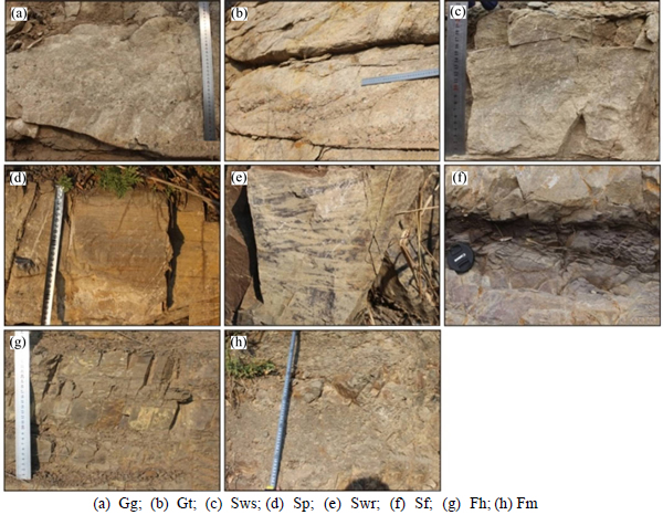
Fig. 4 Typical lithofacies photos in Denglouku formation, Fangniugou section:
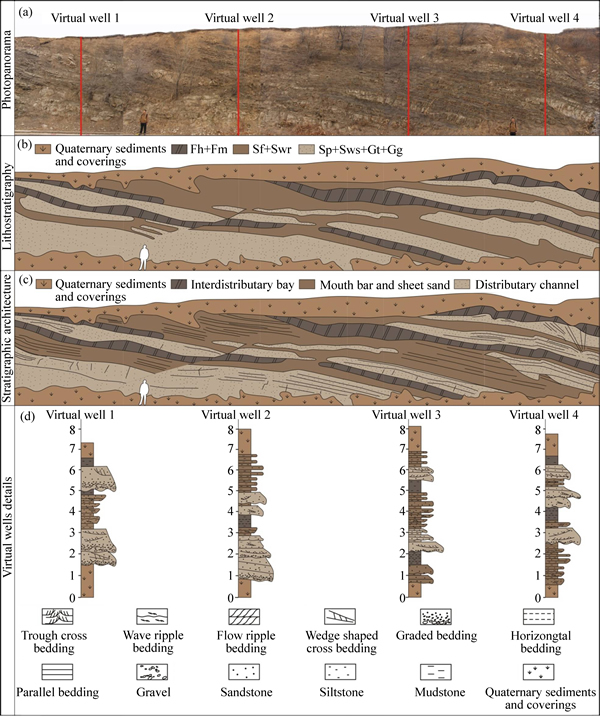
Fig. 5 Photopanorama of Section 2 (a), sketch of Section 2 showing lithostratigraphic units (b), sketch of Section 2 showing sedimentary microfacies (c) and virtual wells details of Section 2 (d)
4.1 Characteristics of four sedimentary microfacies
The underwater distributary channel is characterized by numerous large, graded, strong hydrodynamic sandstone separated by finer-grained interdistributary deposits. This could possibly represent changes in hydrodynamic force caused by water level fluctuations. From bottom to top, the lithoface combination of the underwater distributary channel was usually Gg��Gt�� Sp (Sws)��Sf. The conglomerate and sandstone units overlay and locally scour the finer-grained interdistributary deposits. As a result, the top of the distributary channel is always flat with the bottom material projecting upward. The interdistributary bay consisted primarily of massive mudstone and horizontal bedding siltstone (Fig. 5). Carbon dust could be found distributed along with the beddings.
How do river mouth bars and sheet sand form? It is generally known that at distributary channel mouths sediment-laden flows debouch into a standing body of water in the form of a turbulent plane jet. The turbulent plane jet at the river mouth experiences lateral and bed friction causing it to decelerate and expand rapidly. The transport capacity of the turbulent jet decreases and sediment is sometimes deposited as a broad radial river mouth bar basin at the distributary mouth [16]. The sheet sand is the product of mouth bar, which is locally affected by wave action.
The fluctuation of water levels causes the distance between the off-loading position of the deposits and the lakeshore to change. This also affects the relative strength of the river action and the wave action. This section of this study deals with distances from the lake��s shore. Generally, the mouth bar and sheet sand always develop in unison on a large scale and it is difficult; therefore, to distinguish between their boundaries. The types of lithoface combinations in the mouth bar and sheet sand is Sp��Swr(Sf)��Fh. The mouth bar is characterized by good separation, beddings formed by tractive current and traces of wave transformation. The grain particle size of the fourth order architecture element single mouth bar gradually increases from the bottom to the top. The hyperplasia in single mouth bar, which is equal to the third order architecture element, becomes thicker, reflecting the enhancement of the hydrodynamic conditions. When the sheet sand is compared to the deposits at the mouth bar, it is found that the lithoface of the mouth bar has more fine granularity and sand units are thin (<20 cm) with normally wave ripple beddings and horizontal beddings (Fig. 5).
Table 2 shows the thickness and percentage of lithofacies and sedimentary microfacies of four virtual sample wells in Section 2. From virtual well 1 to virtual well 3, the thickness and percentage of the underwater distributary channels, corresponding to a Sp+Sws+Gt+ Gg composition, decreased while the thickness and composition in virtual well 4 increased. The thickness and percentage of the mouth bar and sheet sand, corresponding to a Sf+Swr composition, increased and the makeup of virtual well 4 decreased. The thickness and percentage of the interdistributary bay, sample corresponding to the Fh+Fm composition, remained relatively stable from virtual well 1 to virtual well 4. These results indicate that water level, as well as the level of hydrodynamics in these areas, initially increased and then decreased.
4.2 Scale of main architecture elements
The source formed the fan delta coming from the southeast uplift zone of Songliao basin [17]. Evidences observed from sedimentary structures in this section also proofed that the section was almost perpendicular to the source direction. As a result, the architecture elements observed in the section is approximate to the cross section. This provided a good opportunity to measure the parameters of the architecture elements. As the number of the fourth order architecture elements (single sand body) is relatively less and exposes incompletely in lateral direction, it do not have obvious characteristics. This work measured the thickness of the third order architecture elements (the hyperplasia in a single sand body). In section 2, 68 fourth order architecture elements of underwater distributary channel, 20 fourth order architecture elements of mouth bar, 49 fourth order architecture elements of sheet sand were recognized. The average thickness of fourth order architecture elements of underwater distributary channel is 42 cm, its thickness mainly focuses on two intervals, 20-30 cm and 30-40 cm. The average thickness of fourth order architecture elements of mouth bar is 29 cm, its thickness mainly focuses on 20-30 cm. The average thickness of fourth order architecture elements of sheet sand is 14 cm, its thickness is less than 20cm mostly (Fig. 6).
5 Effect of water level fluctuation on sedimentary characteristics
Architectural elements of different orders are affected by water level fluctuations of different orders. In the lacustrine basin, the most common type of the petroliferous basin in eastern China, the formation and subduction of a basin��s water storage space are determined by the tectonic subsidence rate [18]. This is the main controlling factor of the water level fluctuation over long time scales. In a stable period in the basin, climate change is the main factor that controls water level fluctuations over medium to short time scales [19]. Something as trivial as individual daily water fluctuation events such as rain or evaporation will influence the overall water level fluctuation. Based on the different orders of water level fluctuation, this work summarizes the corresponding relationship between fluctuating water levels and architecture elements (Table 3). The effects of water level fluctuation on the reservoir architecture will be discussed below.
Table 2 Thickness (m) and percentage (%) of lithofacies and sedimentary microfacies of four virtual wells in Section 2


Fig. 6 Thickness of three kinds of third order architecture elements
5.1 Determination of relative water level
The vertical thickness of Section 1 was 56.7 m and Section 2 is 10.8 m. Section 1 was divided into 4 layers according to the lithology determined in the field, while Section 2 was one layer (Fig. 7).
There are multiple ways of determining the relative historic water level. Usually, this depends on the biological markers, sedimentary structures or the authigenous minerals which are indicators of water depth. Also, the geochemical characteristics, which represent the sedimentary environment can be used. In this work, major chemical elements and trace elements in samples of the sediments were used to calculate the relative water level. Twenty three rock samples were obtained from the five layers in Section 1 and Section 2 averagely. Ten major chemical elements and forty-four trace elements of the samples were determined in the Analytical Laboratory of China National Nuclear Corporation Beijing Research Institute of Uranium Geology. The major elements were determined using an AL104 X-ray fluorescence spectrometer and a PW2404 electronic balance at 22 ��C with 35% relative humidity. The trace elements in the samples were determined using a NexION300D plasma spectrum analyzer at 20 ��C with 30% relative humidity. Table 4 lists a portion of the elemental composition of the samples.
The chemical element U can accurately reflect the geophysical characteristics of the sedimentary strata. The water depth function and water energy function can make a contrast on the relative water depth and energy. It has been stated that when the U content of the sample is zero the water depth for that samples is zero. The numerical value of the U content for each sampling point that deviates from zero reflects the relative water depth. The variance of the relative depth can reflect the depth of each layer:
 (1)
(1)
whrere w(U)i is the U value of each sampling point; D is the variance of water depth function; n is the sample number in each layer.
It has been stated that the content of U is the maximum when the water depth is zero. The numerical value of each sampling point deviating from zero water depth reflects the relative water energy. The variance of the relative energy can reflect the energy of each layer:
 (2)
(2)
where w(U)max is the maximum U value of all sampling points; E is the variance of water energy function; n is the sample number in each layer. Equations (1) and (2) are modified from Ref. [20].
The chemical properties of elements Fe and Mn are obviously quite different. Fe3+ assembles near the river mouth and Mn2+ sediment in the center of the basin after a long migration. The terrigenous clastic rocks high Fe and Al content, while Ca and Mg are primarily found in carbonate rock. As a result, the ratio of Fe/Mn and (Fe+Al)/(Ca+Mg) contents are higher in deepwater [21].
Table 3 Corresponding relationship between water level fluctuation and architecture elements


Fig. 7 Analysis of effects of water level fluctuation on lithofacies
In addition, the ratios of Ca/Mg, Sr/Ba, Sr/Ca content will decrease in deeper water [22].
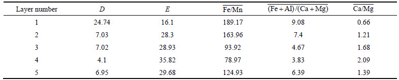
D, E and the average value of the Fe/Mn, (Fe+Al)/(Ca+Mg), Ca/Mg contents in each sediment layer are listed in Table 5. From layer 1 to layer 4, D decreased and E increased, indicating that the water depth decreased and the water energy increased. From layer 4 to layer 5, D increased but E decreased, indicating that the water depth increased and the water energy decreased. From layer 1 to layer 5, the variation of the 
 ratios are identical to D and the variation of the
  ratio is the same as E, indicating that the water depth decreased form layer 1 to layer 4 and also increased from layer 4 to layer 5.
5.2 Effect of water level fluctuation on lithofacies
The studied strata were divided into 3 classes, river- dominated strata, wave dominated strata and hydrostatic strata. River dominated strata consisted of 4 lithofacies, graded bedding conglomerate, trough cross bedding conglomerate, wedge shaped cross bedding sandstone and parallel bedding sandstone. Wave dominated strata included 2 lithofacies, wave ripple bedding sandstone and flow ripple bedding sandstone. Hydrostatic strata included 2 lithofacies, horizontal bedding siltstone and massive mudstone. From layer 1 to layer 4, as the water depth decreased, the thickness of river dominated strata increased, while the thickness of wave dominated strata and hydrostatic strata decreased. The proportion of river dominated strata in layer 4 was the largest, 88.7%, while, the hydrostatic strata was 0%. From layer 4 to layer 5, as the water depth increased, the thickness of the river dominated strata decreased, while the thickness of wave dominated strata and hydrostatic strata increased. For the entire strata, the thickness of river dominated strata was the largest, wave dominated strata was second and the hydrostatic strata was the smallest, reflecting the characteristics of a river dominated delta, which is reformed by slight wave action (Table 6).
Table 4 Part of elements content in the Fangniugou section

Table 5 Calculation results of D, E, 
 ,
,  in each layer of Fangniugou section
5.3 Effect of water level fluctuation on architectural elements
The effect of water level fluctuation on the fifth order architecture element is mainly reflected by the vertical combination of composite sand bodies (Fig. 8).
During average water level conditions, from flood periods to hydrostatic periods, the vertical sequence of the fifth order compound sands consisted of thick layers of sandstone and conglomerate, medium or coarse sandstone reformed by river and wave effect, a thin layer of argillaceous siltstone reformed mainly by the wave effect from bottom to the top. Because of the relatively weak vertical erosion, the mudstone layer is occasionally observed between the bottom single channels sand, but frequently in the upper part. This entire sequence is relatively complete. During low water level conditions, channel erosion removes the upper parts of previously accumulated sediments, so that only the geomorphic elements at the base of the channel are preserved. As a result, the fifth order compound sand bodies are superimposed in the multi-single channel sands, which consist predominantly of cut-and-fill macroforms composed of amalgamated trough-cross bedded, graded bedded and parallel bedded sandstones. The small thin sand strips of interdistributary bay are retained. During high water level conditions, the sediments of flood periods and hydrostatic periods are preserved without further erosion due to the weak river cutting capacity. Compared to the normal water level conditions, the channel sediments are finer and thinner. In the lower part, single channel sands are separated by the transgressive mud layers. In the upper part, river mouth bar and wave-modified sheet sand modified increase. There is a general lack of vertical connectivity throughout the entire sequence.
Table 6 Thickness of 3 kinds of strata in each layer of Fangniugou section
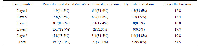
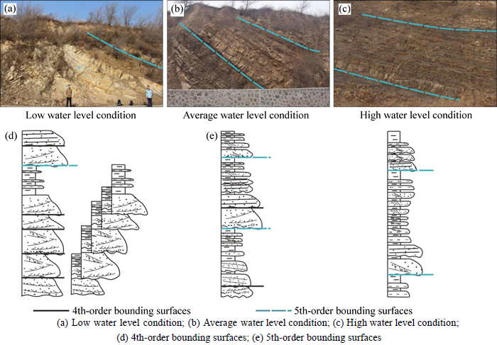
Fig. 8 Analysis of effects of water level fluctuation on 5th-order architecture elements:
The effect of water level fluctuation on the fourth order the architecture element is mainly reflected by the vertical and lateral contact relationship of single sand bodies (Fig. 9). Fluctuations in the lake level reflect the relative balance of sediment+water input versus potential accommodation [23]. During low water level conditions, the sediments�� accommodation is low and the channels�� erosion is strong. The single sand bodies display a light cutting style, a deep cutting vertical style and coherent lateral style. Sand connectivity in this instance is found to be the best. During average water level conditions, the rate of sediments supply is nearly equal to the rate of accommodation growth. The single sand bodies display two distinct vertical styles, a light cutting style and separating style. In the lateral direction the two major styles are the coherent style and the separating style. The sand connectivity is medium. During high water level conditions, the sediments accommodation is the largest, the single sand bodies appear to be channel sand and sheet sand isolated in the mud of the delta front. The sand connectivity is poor. In addition, this issue needs to consider the distance between position of the sediments and the basins�� center. This scenario is a relationship of contact between single sand bodies in the center of the lacustrine basin. Above the shoreline in the slope belt, few delta sediments may exist during low water level conditions.

Fig. 9 Analysis of effects of water level fluctuation on fourth to first order architecture elements:
Short to ultrashort cycles of water level fluctuation influence the third to first order architecture elements. For example, consider the decline of water level, which forms serious upward-thinning hyperplasia in a single sand body of the third order of architecture element. From the second to the first, this condition results in the reduction of particle size in the single coset or lamina (Fig. 9).
6 Sedimentary model for different water level conditions
Figure 10 summarizes the sedimentary model of different water level conditions for the lake river dominated delta, based on the effects of water level fluctuation on the sedimentary characteristics and reservoir architecture. During low water level conditions, the climate is typically arid with small river runoff and sediment injection. Together with the migration of the shore towards to the center of the basin, the delta rapidly extends forward, the distributary channel develops and the delta looks like a river. From the gentle slope belt to the center of the basin, the lacustrine basin is covered by the delta sand, characterized by a large delta plain and small delta front. The hydrodynamic is weak, the distributary channel is a narrow branch with a small interflow, bifurcation and few crevasses. The mouth bar is less developed and not subject to wave to sheet sand action. The section in the center of the basin displays a sand connection, laterally linked and vertically overlaid. In the slope belt, the distributary channel appears to be isolated.
During high water level conditions, the climate is wet and the sources in the upper river unload into the estuary area. With the rise of the shore line, the delta sands draw back towards to the edge of the basin. The delta plain is small and the delta front is well developed. The channel, like a net, is relatively wide with frequent interflows, bifurcation and crevasses. The mouth bar is large. There is a large amount of sheet sands that are restructured by wave action. The center of the basin develops a lake and a small amount of endmost channel, sheet sand and mouth bar. In the slope belt, the river channel and mouth bar sand dominate and the crevasse sand occurs occasionally. The single sand body showed a light cutting style, a deep cutting style in the vertical direction and cohering style in lateral direction with good connectivity.
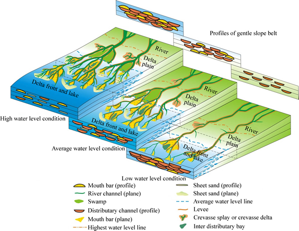
Fig. 10 Sedimentary model for lake river dominated delta in different water level conditions
In average water level conditions, the development, distribution and the contact relationship of the sand is somewhere between the two described scenarios. The difference is that in the center of the basin, the mouth bar, endmost channel and sheet sand constitute the main sand styles. The single sand is small; however, there are many underwater distributary channel sands and little sheet sand in the slope belt.
The delta sands advance and retreat largely with the migration of the shore line under various water level conditions. The sand types and combined relationships are different in the center of the basin and on the slope belt. As a result, when the petroliferous basin is studied, the specific situation should be considered based on the distance between the selected research area and the center of the basin.
7 Conclusions
1) In the Fangniugou section of the eastern Songliao Basin, 8 lithofacies are identified. The fan delta front, develops four sedimentary microfacies, the underwater distributary channel, river mouth bar, sheet sand and interdistributary bay.
2) Architectural elements of different orders are affected by water level fluctuations of different orders in the basin. The effects of water level fluctuation on the fifth, fourth, third, second to first orders architectural elements are respectively reflected in the vertical combination of the composite sand bodies, the plane combination of the single sand bodies, the particle size changes in vertical of hyperplasia in single sand, coset and lamina.
3) Future studies of the petroliferous basin should consider that the effect of water level fluctuations and the distance of the study area from the basins�� center. In the center of the basin, during high water level conditions, the lake develops in large scale and less degrees of channels, sheet sand and mouth bar. In the slope belt. A river channel and mouth bar sand dominate the delta and crevasse sand is occasionally presents. The single sand body will exhibit light cutting style, deep cutting style in vertical direction and a cohering style in lateral direction with good connectivity. During low water level conditions, the section in the center of the basin will exhibit well connected sands connect, linked in the lateral direction with overlaid sand in the vertical direction. In the slope belt, isolated distributary channels will appear. During the average water level conditions, the center of the basin, mouth bar, endmost channel and sheet sand will be the main sand types, single sand bodies will be sparse; however, there will be a large amount of underwater distributary channel sands and not much sheet sand in the slope belt.
References
[1] JIANG Zai-xing. Sedimentology [M]. Beijing: Petroleum Industry Press, 2003: 393-394. (in Chinese)
[2] CARI L J, STEPHAN A G. Sedimentology and reservoir architecture of a synrift lacustrine delta, Southeastern Mongolia [J]. Journal of Sedimentary Research, 2004, 74(6): 770-785.
[3] BOYAN K V, R BRUCE A. A hierarchical approach to architectural classification in marginal-marine systems: Bridging the gap between sedimentology and sequence stratigraphy [J]. AAPG Bulletin, 2013, 97(7): 1121-1161.
[4] STANLEY D, WARNE A. Worldwide initiation of Holocene marine deltas by deceleration of sea-level rise [J]. Science, 1994, 265: 228-231.
[5] ZHAO Xiao-qing, BAO Zhi-dong, LIU Zong-fei, ZHAO Hua, CHAI Qiu-hui. An in-depth analysis of reservoir architecture of underwater distributary channel sand bodies in a river dominated delta: A case study of T51 Block, Fuyu Oilfield [J]. Petroleum Exploration and Development, 2013, 40(2): 181-187. (in Chinese)
[6] SHI Zhan-zhong, JI You-liang. Fan-delta sedimentation formed under the environment of lake level frequently varying��Taking the first member of Kongdian Formation, Huanghua Depression as an example [J]. Journal of Xi��an Petroleum Institute: Natural Science Edition, 2002, 17(1): 24-29. (in Chinese)
[7] LOU Zhang-hua, YUAN Di, JIN Ai-min. Types, characteristics of sandbodies in shallow-water delta front and sedimentary models in Northern Songliao Basin, China [J]. Journal of Zhejiang University: Science Edition, 2004, 31(2): 211-215. (in Chinese)
[8] ZHU Xiao-min. LIU Yuan, FANG Qing, LI Yang, LIU Yun-yan, WANG Rui, SONG Jing, LIU Shi-qi, CAO Hai-tao, LIU Xiang-nan. Formation and sedimentary model of shallow delta in large-scale lake. Example from Cretaceous Quantou Formation in Sanzhao Sag, Songliao Basin [J]. Earth Science Frontiers, 2012, 19(1): 89-99. (in Chinese)
[9] BUREAU of geology and mineral resources of Jilin province. Journal of the regional geology of Jilin province [M]. Beijing: Geological Publishing House, 1922: 228.
[10] JIANG Zheng-long, QIU Hai-jun, PENG Yu-jing, ZHANG Wei-min, LIANG Shuang. Zircon SHRIMP U-Pb dating for island arc volcanic rock of Fangniugou area in Yitong region of Jilin Province [J]. Journal of Central South University, 2014, 21: 2877-2884.
[11] CHENG Ri-hui, WANG Teng-fei, SHEN Yan-jie, REN Yan-guang. Architecture of volcanic sequence and its structure control of Yingcheng Formation in Songliao Basin [J]. Journal of Central South University, 2014, 21: 2026-2040.
[12] MIALL A D. Reconstructing the architecture and sequence stratigraphy of the preserved fluvial record as a tool for reservoir development: a reality check [J]. AAPG Bulletin, 2006, 90: 989-1002.
[13] MIALL A D. Hierarchies of architectural units in clastic rocks, and their relationship to sedimentation rate [C]// MIALL A D, TYLER N. The Three-Dimensional Facies Architecture of Terrigenous Clastic Sediments, and Its Implications for Hydrocarbon Discovery and Recovery. Soc Eco Paleontol Mineral Conc Sedimentol Paleontol, 1991, 3: 6-12.
[14] WEN Li-feng, WU Sheng-he, WANG Yan-zhong, YUE Da-li, LI Yan-ping. An accurate method for anatomizing architecture of subsurface reservoir in mouth bar of fluvial dominated delta [J]. Journal of Central South University: Science and Technology, 2011, 42(4): 1072-1078. (in Chinese)
[15] CHEN Bin-tao, YU Xing-he, PAN Shu-xin, TANG Cheng-peng, LI Shun-li, ZHANG Yu-pan. Sedimentary characteristics and sedimentogenic-based sandbodies correlation methods of meandering river in Toutunhe Formation, southern margin of Junggar Basin [J]. Natural Gas Geoscience, 2013, 24(6): 1132-1139. (in Chinese)
[16] EDMONDS D A, SLINGERLAND R L. Mechanics of river mouth bar formation: Implications for the morphodynamics of delta distributary nerworks [J]. Journal of Geophysical research, 2007, 112(F3): 237-254.
[17] LI Zhan-dong, LI Yang, LIU Yun-li, HU Hui-ting, MA Feng-rong, ZHANG Xiao-gang. Sedimentary characteristics of the Cretaceous Denglouku Formation in the southeast uplift of the southern Songliao Basin [J]. Oil & Gas Geology, 2014, 35(3): 401-409. (in Chinese)
[18] CARROLL A R, BOHACS K M. Stratigraphic classification of ancient lakes: Balancing tectonic and climatic controls [J] .Geology, 1999, 27: 99-102 .
[19] WU Wei, LIN Chang-song, ZHOU Xin-huai, LI Quan, XING Zuo-chang, YAN Yu. Paleoclimate evolution and its influence on lake level changes of Paleogene Dongying epoch in Liaodong Bay, East China [J]. Journal of China University of Petroleum, 2012, 36(1): 33-39. (in Chinese)
[20] CHEN Zhong-hong, ZHA Ming. Application of uranium curve to paleoenvironment inversion in sedimentary basin [J]. Journal of the University of Petroleum, China, 2004, 28(6): 11-15. (in Chinese)
[21] ZHANG Yong-sheng, YANG Yu-qing, QI Zhi-xian, QIAO Yue-dong, YUAN He-ran. Sedimentary characteristics and environments of the salt-bearing series of Qianjiang Formation of the Paleogene in Qianjiang sag of Jianghan basin [J]. Journal of Paleogeography, 2003, 5(1): 29-35. (in Chinese)
[22] CHEN Zhong-hong, ZHA Ming, JIN Qiang. Mineral elemental response to the evolution of terrestrial brine faulted-basin: A case study in the Paleogene of Well Haoke-1, Dongying Sag [J]. Acta Sedimentologica Sinica, 2008, 26(6): 925-932. (in Chinese)
[23] BOHACS K M, CARROLL A R, NEAL J E, MANKIEWICZ P J. Lake-basin type, source potential, and hydrocarbon character: An integrated sequence-stratigraphic�Cgeochemical framework [C]// GIERLOWSKI-KORDESCH E H, KELTS K R. Lake Basins through Space and Time, Studies in Geology. New York: American Association of Petroleum Geologists, 2000, 46: 3-34
(Edited by DENG L��-xiang)
Foundation item: Project(2011ZX05009-002) supported by the National Key Oil & Gas Project, China; Project(15CX06010A) supported by the Fundamental Research Funds for the Central Universities, China
Received date: 2015-08-08; Accepted date: 2016-01-08
Corresponding author: QIU Long-wei, Professor, PhD; Tel: +86-18561332099; E-mail: qiulwsd@163.com
Abstract: The hydrodynamic conditions present in a river delta��s formation are a highly important factor in the variation between its sedimentary regulation and characteristics. In the case of the lacustrine basin river-dominated delta, water level fluctuations and fluviation, are both important controlling factors of the sedimentary characteristics and reservoir architecture. To discuss the effects of water level fluctuation on sediment characteristics and reservoir architecture of this delta, the Fangniugou section in the east of the Songliao Basin was selected for study. Based on an outcrop investigation of the lacustrine basin river-dominated delta, combining with an analysis of the major and trace chemical elements in the sediments to determine the relative water depth, through architecture bounding surfaces and lithofacies division, sedimentary microfacies recognition and architectural element research, this work illustrated the effects of water level fluctuation on the reservoir architecture and established sedimentary models for the lacustrine basin river-dominated delta under various water level conditions. The results show that there are 8 lithofacies in the Fangniugou section. The fan delta front, which is the main object of this study, develops four sedimentary microfacies that include the underwater distributary channel, river mouth bar, sheet sand and interdistributary bay. The effects of water level fluctuation on different orders geographic architecture elements are respectively reflected in the vertical combination of the composite sand bodies, the plane combination of the single sand bodies, the particle size changes in the vertical of hyperplasia in the single sand body, the coset and lamina. In the case of the sand body development of the petroliferous basin, varying water level conditions and research locations resulted in significant variation in the distribution and combination of the sand bodies in the lacustrine basin.