���ģ�ɳ���ά̽�⼰�ز�ָ����ӻ�����
����ȫ1��������1����ľ��2��Ҧ ��2����ʤ��2������2
(1. ���ϴ�ѧ ��Դ�밲ȫ����ѧԺ������ ��ɳ��410083��
2. ����Ǧп�㶫 �عأ�512325)
ժ Ҫ��
ժ Ҫ������ҹ�������ɽ���ģ�ɳ��ز�ָ������ȷ��ȡ����״���ۺ����ÿ�������̽��ϵͳ(CMS)�ʹ��Ϳ���ά����Surpac�����ֻ����ߣ���Ϸ���Ǧп��N3-4�ɳ�ʵ�ʣ��о�һ����ӱ�Ĵ��ģ�ɳ��ز�ָ����ӻ����㷽��������CMS̽����ά�ɳ��������Կ���ʵ������Ϊ��������Surpac�����ɿ�����ά���ӻ�ģ�ͣ���ȡ�ɳ���������ά��̬��ʵ�ʱ߽磻���òɳ�������ϣ������ɳ��ز����ģ�ͼ����ұ߽�ģ�ͣ�ͨ��ģ�ͼ�IJ������㣬������ɳ������������ز�����������·�ʯ�������³������������´���ʯ�����ز��������ز�ƶ���ʵȣ��Ӷ���Ч��ʵ���˴��ģ�ɳ��ز�ָ��Ŀ��ӻ����㡣�о�������������ø÷��������õIJɳ��ز�ָ��ɿ��������ڿ�ɽʵ�����������ͻز�����������
�ؼ��ʣ�
����̽��ϵͳ����άģ�����ز�ָ�������ӻ���
��ͼ����ţ�TD853.391 ���ױ�־�룺A ���±�ţ�1672-7207(2009)06-1732-05
Stope 3D monitoring and its mining index visible calculation
LUO Zhou-quan1, LIU Xiao-ming1, ZHANG Mu-yi2, YAO Shu2, CAO Sheng-xiang2, LUO Ze-hua2
(1.School of Resources and Safety Engineering, Central South University, Changsha 410083, China;
2. Fankou Lead-Zinc Mine, Shaoguan 512325, China)
Abstract: Aimed at the difficulty in gaining large-scale stope mining index accurately in domestic metal mines, and with the cavity monitoring system (CMS), mining 3D software Surpac, and the actual situation of stope N3-4 of Fankou Lead-Zinc Mine, a new visible calculation method of mining index for large stope was developed. Firstly, the stope vacancy was monitored using CMS, taking cavity measured data as foundation, cavity three-dimensional model of the stope opening was created using Surpac software and gain the stope three-dimensional configuration and the actual boundary accurately. Then, the stope designed model and ore-rock interface digital terrain model (DTM) were established according to the stope design material. Finally, using ore-rock interface DTM to cut cavity model or through Boolean calculation among the models, ore remains, mining total volume, mullock, backfilling, pure ore and dilution rate of stope N3-4 were calculated accurately, thus the large-scale stope mining index visible calculation was realized effectively. The practice indicates that the stope mining indexes obtained by this method are reliable and can be used in actual production management and mining quality appraisal.
Key words: cavity monitoring system; three-dimensional model; mining index; visible
���ڲ����������״��ģ���Ʋɳ����ɵĽ�����ɽ�����ȷ����Ч�ػ�ȡ�ɳ��زɺ��ʵ�ʲɿ����������´���ʯ�������·�ʯ����������ʯ���Լ��ز�ƶ���ʡ���ʧ�ʵȻز�ָ�꣬�ԸĽ��زɹ��պ����ۿ�������������Ҫ��ʵ����[1-4]����ǰ���ڰ�ȫԭ������Ա���Խ���ɳ���������ʵ�ʲ��������������ز�ָ������ֻ�ܸ��ݲɿ���ƣ�����Ͼ�����м��㣬����������ʵ��������ϴ�Ϊ�ˣ����������Է���Ǧп��N3-4�ɳ�Ϊʵ���о������о���һ����ӱ�Ĵ��ģ�ɳ��ز�ָ����ӻ����㷽�������������˼·�ǣ����ÿ������⾫��̽��ϵͳ(Cavity monitoring system��CMS)�Բɳ�����������ά̽�⣬�Կ���ʵ������Ϊ������������ά��ҵ����Surpac�����ɿ�������ά���ӻ�ģ�ͣ�ȷ��ȡ�ɳ���������ά��̬��ʵ�ʱ߽磻���òɳ�������ϣ������ɳ��ز����ģ�ͼ����ұ߽�ģ�ͣ������γɵĿ��ұ߽�ģ�Ͷ���������ģ�ͽ������л�ͨ��ģ�ͼ�IJ������㣬�����ȡ�ɳ��زɵ�����������·�ʯ�������³������������´���ʯ�����ز��������ز�ƶ���ʺ���ʧ�ʣ��Ӷ���Ч��ʵ�ִ��ģ�ɳ��ز�ָ��Ŀ��ӻ����㣬Ϊ��ɽ��һ���Ľ��ɳ����ƻزɹ��գ���߿��������ṩ�ɿ����ݡ�
1 �ɳ���������̽��
1.1 �ɳ��ſ�
����Ǧп��N3-4�ɳ�Ϊ�����ɳ����ɳ��ϱ�����ֱ�ΪN3�ź�N4�Ųɳ��ij����壬�ɳ���ͷΪF102�ϲ㣬�Ӷϲ�������y=718����������Ϊ�ɳ����ȷ�Χ���زɸ߶ȴ�-280 m���ֶε�-240 m�ж�ƽ�棬�ɳ���Ϊ8 m���ײ���-280 m�ֶ�ƽ��Ϊ�����壬����-240 m�ж�ƽ�浽-240 mһ�ֶ�Ϊ�����塣�ɳ��ڿ�����̬����ʯ����Ҫ���Ϊ��״����״����Ǧп����ɢ����Ǧп���ڶϲ��������д��ڡ���״����Ǧп��ƽ���ܶ�Ϊ4.11 t/m3��Χ��ƽ���ܶ�Ϊ2.74 t/m3��������ɢϵ��Ϊ1.4~1.6���������Եȼ�Ϊ��~�����������Եȼ�Ϊ��~��������ʯΪ�����ʯ�����Ⱥͽ�顣��ʯ�У�Pb��Zn��SƷλ�ֱ�Ϊ6.04%�� 10.70%��29.39%��
1.2 ��������̽��
��������̽��ϵͳ��һ�ֻ��ڼ���Ŀ�����ά̽��ϵͳ��������ȷ�ⶨ���²ɿ������������ҿռ����ά��̬�����㷺Ӧ���ڹ���������¿�ɽ[5-8]��̽��ɹ���ֱ�����ڼ�����������ȷ������ʵ�ʱ߽磬ָ�������������������ơ��ز�ƶ������Լ������ȶ��Է�������زɿ�������̿��ơ�CMS�Ļ������ɰ�������ɨ��ͷ�������䡢�ֳ�ʽ��������֧�Ÿ˼ܼ����ݴ�������[5]��CMS̽�⼰���������������ͼ1��ʾ��
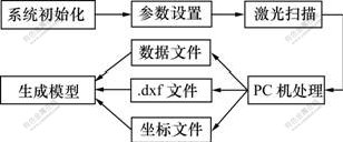
ͼ1 CMS̽�⼰������������
Fig.1 Workflows of CMS and post-processing
2 �ɿ�����άģ������
CMS̽���������õ�ԭʼ���������CMSԤ��������CMSPosProcess���д��������γɡ�.dxf����ʽ��ԭʼ�����ļ������ļ��ɱ���3������Surpac��Gocad�Ƚ��ܣ��������ɿ�����άʵ��ģ�͡�
�Կ���ԭʼ̽�����ݽ��д���������Surpac���ɲɿ�����άʵ��ģ�ͣ����巽�����£�
a. ����Surpac���ݵ���ӿڽ���.dxf����ʽ�ļ�ת����ʵ��ģ�͵ġ�.DTM����ʽ�ļ���
b. ��֤ʵ��ģ�ͣ�
c. ��ʵ��ģ����֤�д�����ת�벽��d������ת�벽��e��
d. ���½���ԭʼ̽�����ݵ�ת�������������ز���e��
e. ����Surpac��ʵ��ģ�ͱ༭���߶Կ���ģ�ͽ��б�Ҫ�ı༭(ͨ������ʵ��ģ�Ͳ�������ķ����Կ����Ե�������ֽ����и��)��
f. �ٴ���֤�ĺ��ʵ��ģ�ͣ��������ز���e���ٴα༭ģ�ͣ���֮����ɲɿ�����άģ����[9-16]��ͼ2��ʾΪ�ô��Ϳ�ɽ��ά����Surpac���ɵķ���Ǧп��N3-4�ɳ�������άģ�͡�
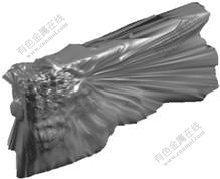
ͼ2 N3-4�ɳ�������άģ��
Fig.2 Three-dimensional cavity model of N3-4 stope
3 �ɳ��ز�ָ�����
3.1 ������ʯ������
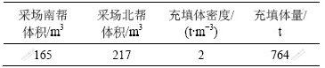
һ��أ����ô��ƻزɵIJɳ������ڿ�ʯ���ʡ���ȡ��ײ��ṹ�����Լ������·̮�������ص�Ӱ�죬�ز���Ϻɳ��ڲ��������в��ֿ�ʯ����ȫ���ա������յIJɳ�������ʯ����ɲɳ��ز���ʧ����Ҫԭ��Ȼ�������ڿ�N3-4�ɳ����ý�·ʽ�������ң�����ң�ز��˻����������ҵװ���ƽ������ʵ�Ľ����棬��ˣ����µĿ�ʯ������ȫ���գ�ֻ���ڲɳ�����̽��ʱ���ɳ��ײ��в�����ʱû�г���Ĵ�����ʯ��Ϊ�����ⲿ�ֿ�ʯ�����Բɳ�����̽��ģ��Ϊ��������ȡ̽��ɿ���ģ�͵ĵײ��߽��ߺͲɳ��ײ���Ʊ߽��ߣ�����Surpac��������������άģ�ͣ�������ɿ�����άģ���ϣ���ͼ3��ʾ�����ô���������άģ�ͼ�������������������������ʯ������������1��
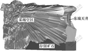
ͼ3 N3-4�ɳ�����������̽�������άģ����
Fig.3 Cavity and ore remains compositing model of stope N3-4
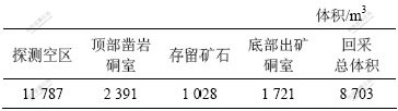
��1 N3-4�ɳ���������������
Table 1 Ore remains calculation results of stope N3-4

3.2 �ز����������
Ϊ����ز���������ȸ���ʵ�����ݹ����ɳ��ײ�����������άģ�ͣ�������ͼ4��ʾ�����ݿ�ɽҪ��Ϊȷ����ز����������Ҫ�۳�ԭ�����ڲɳ����������и�Ķ���������൱�ڰ뾶Ϊ1.05 m��Բ���쾮�����Ϊ�ˣ������쾮��ʵ��λ�ý����쾮��άģ��(�μ�ͼ3)�������ɳ�����̽��ģ�����쾮ģ�ͽ��в������㣬��ÿ۳��쾮��IJɳ�������άģ�͡����ڲɳ�����̽��ʱ�ɳ������в�����ʱδ����Ĵ������������ԣ�����ʱ��������ⲿ����������⣬̽������ķ�Χ�����˲ɳ������������Ҽ���ز������ʱ����ˣ��ⲿ�����ҲҪ��ȥ���������õ�N3-4�ɳ��ز����������2��
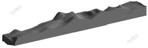
ͼ4 N3-4�ɳ��ײ�����������άģ��
Fig.4 Three-dimensional model of ore output laneway at bottom of stope N3-4
��2 N3-4�ɳ��ز������������
Table 2 Mining total volume calculation result of stope N3-4
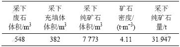
3.3 ���·�ʯ������
ͼ5��ʾΪN3-4�ɳ��������ײ����Ҽ����������˿��ҷֽ���ģ����ͼ�����Կ������ڲɳ��Ķ��������˾����ڲ��·�ʯ��������·�ʯ���ľ��岽�����£�
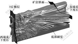
ͼ5 N3-4�ɳ��������ײ����Ҽ������˿��ҷֽ��渴��ģ��
Fig.5 Composite model of cavity, bottom ore output laneway and ore-rock interface of stope N3-4
a. ��ȡ�ɳ�������������еIJɳ����嶫�����˱߽��ߣ����������Զϲ�F102Ϊ�ֽ��棻
b. ���߽��ߵ�����Ϳ���ά����Surpac������������άת����ʹ�����ɽʵ�����������
c. �ֱ𰴶������������ɿ��ұ߽���DTM��
d. �ֱ������߽�����̽�����ģ���ϣ������в������㣬�γɶ����IJɳ����������˲��·�ʯ��άģ�ͣ�
e. �������ɵIJ��·�ʯ��άģ�ͼ�����·�ʯ������������3��
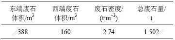
��3 N3-4�ɳ����·�ʯ��������
Table 3 Mullock quality calculation results of stope N3-4
3.4 ���³�����������
N3-4Ϊ�����ɳ�����������Ѳ��겢���г����ˣ��ڻزɹ����У�����ʹ����ij�������䡣Ϊ��ȡʵ�ʻزɹ����вɳ�����������������Ӧ��ʵ���N3-4�����ɳ�������άģ�ͣ���Ͽ�ɽ�ṩ�IJɳ�����ز�ʱʵ��ĸ����ֲ�߽�ͼ������N3-4�ɳ�����߽������άģ�ͣ��ٽ�����زɱ߽���ģ����ɳ�������άģ���ϣ����в������㣬��ģ�ͽ������У���òɳ�������³�������άģ�ͣ����ø�ģ�Ϳɷֱ����ɳ�������³���������ͼ6��ʾΪN3-4�ɳ��ϡ���������³�������άģ�͡�N3-4�ɳ����³��������ļ���������4��
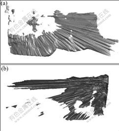
(a) �ϰ�; (b) ����
ͼ6 N3-4�ɳ��ϡ���������³�������άģ��
Fig.6 Backfilling three-dimensional model of south and north side of stope N3-4
��4 N3-4�ɳ�������³�������������
Table 4 Backfill quality calculation results of stope N3-4
3.5 ���´���ʯ������
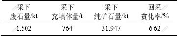
�زɹ����еIJ��´���ʯ��Ϊ�ز�������ȥ���·�ʯ���Ͳ��³������������������������N3-4�ɳ��زɹ����в��µĴ���ʯ��������5��
��5 N3-4�ɳ����´���ʯ��������
Table 5 Pure ore quality calculation results of stope N3-4
3.6 ƶ����ʧ����
�ɳ�ƶ����Ҫ�ǵ��������Ͳɿ�����ԭ��ʹ���µĿ�ʯ�л��з�ʯ���Ӷ������ʯƷλ����[4]���ز�ƶ������ָ�زɹ����в��µķ�ʯ��ռ���¿�ʯ�����ز�����(��������ķ�ʯ��)�İٷֱȡ���ʯ��ʧ����ָ���ڶ��ԭ����ɵĿ�ʯ����������ȫ�ɳ�������ͨ������������ʧ��δ������ʧ������N3-4�ɳ����ز�����Ϊ�زɹ����в��µĴ���ʯ�������·�ʯ��������������ܺ͡�����N3-4�ɳ�����̽��ʱ���ɳ������в��ִ�����ʯ�����ⲿ�ֿ�ʯ����������ȫ���գ���ˣ���Ϊ�òɳ�û�в�����ʧ�����⣬����̽���õIJɳ�������άģ�ͷ������ֳ��۲죬N3-4�ɳ�Ҳ������δ������ʧ����N3-4�ɳ��ز�ƶ����ӦΪ�زɹ����в��·�ʯ������³�������֮���ٳ��Իز�������N3-4�ɳ��ز�������ƶ���ʵļ���������6��
��6 N3-4�ɳ��ز�ƶ���ʼ�����
Table 6 Dilution rate calculation results of stope N3-4
4 �� ��
a. ����ҹ�������ɽ���ģ�ɳ��ز�ָ������ȷ��ȡ����״���ۺ����ÿ������⾫��̽��ϵͳCMS�ʹ��Ϳ���ά����Surpac�����ֻ����ߣ���Ϸ���Ǧп��ʵ�ʣ��о���һ����ӱ�Ĵ��ģ�ɳ��ز�ָ����ӻ����㷽����
b. ���øô��ģ�ɳ��ز�ָ����ӻ����㷽���������Ծ�ȷ�����ɳ��������ӻ��̶ȸߡ��ɱ༭��ǿ����άģ�ͣ�ȷ�ػ�ȡ�ɳ���������ά��̬��ʵ�ʱ߽磬���ҿ���Ч�ؽ��вɳ��زɵĻز�����������·�ʯ�������³������������´���ʯ�����ز��������ز�ƶ���ʵȻز�ָ��Ŀ��ӻ����㡣
c. �ô��ģ�ɳ��ز�ָ����ӻ����㷽��ʵ�á��ɿ����Ӷ�Ϊ��ɽȷ���տ������������ƻزɹ��տ�����һ���µ���Ч;����
�ο����ף�
[1] ����ȫ, ¹ ��, ������, ��. ���ڿ���̽��IJɳ���Ƿ�������㼰���尲ȫ����[J]. ������ɽ, 2007(12): 36-38.
LUO Zhou-quan, LU Hao, LIU Xiao-ming, et al. The volume calculation of stope over-excavation and under-excavation and upper openings safety analysis based on CMS survey[J]. Metal Mine, 2007(12): 36-38.
[2] ����ƽ. �Ŷ�ú���ɶ�úƶ�����Ż��о�[J]. ú̿ѧ��, 2000, 25(2): 137-140.
GUO Zhong-ping. Study of optimization on the dilution ratio of roof coal in sublevel caving mining[J]. Journal of China Coal Society, 2000, 25(2): 137-140.
[3] ������, ����ȫ, �� ��, ��. CMS����̽��Ļ���Ӱ�켰�����������[J]. ��ұ����, 2008, 28(4): 1-5.
LIU Xiao-ming, LUO Zhou-quan, ZHANG Bao, et al. Error analysis and amend of model under environmental impact for cavity monitoring system[J]. Mining and Metallurgical Engineering, 2008, 28(4): 1-5.
[4] ����ȫ, �� ��, ������, ��. ����CMS����̽��IJɳ�ƶ����ʧ���㷽��[J]. ������ɽ, 2007(10): 84-88.
LUO Zhou-quan, ZHANG Bao, LIU Xiao-ming, et al. Calculation method for mining loss and dilution based on CMS precision survey[J]. Metal Mine, 2007(10): 84-88.
[5] Optech System Corporation. Cavity monitoring system wireless user manual[M]. Toronto: Optech System Corporation, 2004.
[6] Jarosz A, Shepherd L. Application of cavity monitoring system for control of dilution and ore loss in open stopes[C]// Proceedings of 11th International Congress of ISM. Cracow, Poland, 2000: 155-164.
[7] Daniel F H, Nicolas V. Automatic three-dimensional underground mine mapping[J]. The International Journal of Robotics Research, 2006, 25(1): 7-18.
[8] Huber D, Vandapel N. Automatic 3D underground mine mapping[J]. International Journal of Robotics Research, 2005, 25(1): 7-17.
[9] ������, ����ȫ, ������, ��. ��άGIS�ռ����ݼ��ɺͿ��ӻ������о�[J]. �Ƽ�����, 2008, 26(10): 65-68.
LIU Xiao-ming, LUO Zhou-quan, SUN Li-juan, et al. Integration of 3D GIS spatial data and its visualization[J]. Science and Technology Review, 2008, 26(10): 65-68.
[10] LUO Zhou-quan, LIU Xiao-ming, SU Jia-hong, et al. Deposit 3D modeling and application[J]. Journal of Central South University of Technology, 2007, 14(2): 225-229.
[11] ������, �½���, ������. ���Ϳ�ɽ�ؿ���ά���ӻ�ģ�͵Ĺ���[J]. ���ϴ�ѧѧ��: ��Ȼ��ѧ��, 2008, 39(3): 423-428.
ZHOU Zhi-yong, CHEN Jian-hong, YANG Li-bing. 3D visualization modeling on geological and mining engineering in a large-sized mine[J]. Journal of Central South University: Science and Technology, 2008, 39(3): 423-428.
[12] Lemon A M, Jones N L. Building solid models from boreholes and user-defined cross-sections[J]. Computers & Geosciences, 2003, 29(3): 547-555.
[13] John G H, Hani S M. Numerical modelling of ore dilution in blasthole stoping[J]. International Journal of Rock Mechanics and Mining Sciences, 2007, 44(5): 692-703.
[14] LIU Yu-zhou, LI Xiao-hong. Safety analysis of stability of surface gas drainage boreholes above goaf areas[J]. Journal of China Coal Society, 2007, 13(2): 149-153.
[15] GONG Jian-ya, CHENG Peng-gen, WANG Dong-yang. Three dimensional modeling and application in geological exploration engineering[J]. Computers & Geosciences, 2004, 30(4): 391-404.
[16] FANG Yuan-min, DENG Jin-can, MI Hong-yan. Construction and visualization of 3D vacant place model[J]. Journal of Central South University of Technology, 2005, 15(S1): 61-64.
�ո����ڣ�2008-11-08�������ڣ�2009-03-02
������Ŀ�����ҡ�ʮһ�塱�Ƽ�֧�żƻ���Ŀ(2007BAK22B04-12��2006BAB02B05-01-02-01)�����ϴ�ѧ�о���ѧλ���Ĵ��»���������Ŀ(1960-71131100008)
ͨ�����ߣ�����ȫ(1966-)���У����������ˣ���ʿ�����ڣ���ʿ����ʦ�����¿�������밲ȫԤ�����ֻ������뼼���о����绰��13808421339��E-mail: lzq505@hotmail.com