基于地理处理服务的滑坡敏感性区划研究
王卫东,曾科,方理刚
(中南大学 土木工程学院,湖南 长沙,410075)
摘要:在ArcGIS Server平台下开发地理处理服务(GP服务),实现滑坡敏感性区划图的自动化编制。其步骤为:首先,阐述GP服务二次开发方法及其在地质灾害自动化分析和网络发布中的作用;然后,以贵州省为研究区域,选择高程、坡度、岩性、地质构造、铁路建设和年均降雨量6个致灾因子及其二级指标建立滑坡敏感性区划研究体系;最后,以主客观综合权重方法为原型构建滑坡敏感性区划GP模型,并发布为网络服务,在WebGIS系统中调用该服务自动编制贵州省滑坡敏感性区划图。将敏感性区划图与历史滑坡分布图比较,证明了GP模型的可靠性。
关键词:滑坡敏感性区划;地理处理服务;模型库;WebGIS系统
中图分类号:P642.22 文献标志码:A 文章编号:1672-7207(2011)07-2086-09
Landslide susceptibility mapping based on geoprocessing service
WANG Wei-dong, ZENG Ke, FANG Li-gang
(School of Civil Engineering, Central South University, Changsha 410075, China)
Abstract: A landslide susceptibility mapping was automatically established by developing a geoprocessing service (GP service) in the environment of ArcGIS Server. The procedures were as follows. Firstly, the method of GP developing and the significances of GP services in geological hazard automatically analysis and network publishing were expatiated. Then, six causal factors, i.e., elevation, slope, lithology, geological structure, railway construction and annual rainfall, including their subclasses, were selected to establish a landslide susceptibility mapping of Guizhou Province. Finally, according to the weighting method of subjective and objective synthesis, an automatic GP model of landslide susceptibility mapping was created and published on web. A landslide susceptibility map of Guizhou Province was established through GP modeling in the environment of WebGIS system. The reliability of the GP model was proved by statistical results obtained from the comparison of susceptibility map and inventory map.
Key words: landslide susceptibility mapping; geoprocessing service; model library; WebGIS system
我国是世界上滑坡灾害最严重的国家之一。近10年来,我国地质灾害预防和防治水平逐步提高,然而,对地质灾害的预防研究较少[1],因此,应加强地质灾害预警预报研究。滑坡敏感性区划属于滑坡空间预测的一个分支,能定量或半定量地评价区域内滑坡敏感性等级程度,可有效应用于防灾减灾工程[2]。地理信息系统(GIS)因其具有强大的地理信息处理、存储、管理、分析和展示功能[3],已成为分析地质灾害的主要技术方法之一。网络地理信息系统(WebGIS)的出现,使得地理信息的网络共享成为可能。在ArcGIS Server平台上二次开发的地理处理服务(GP服务)能将桌面系统的空间分析功能移植到Web应用程序中,极大地增强了Web应用程序的地理信息处理能力[4]。在 此,本文作者以主客观综合权重方法为原型构建滑坡敏感性区划GP模型,并将GP模型发布为网络服 务,实现基于GP服务的贵州省滑坡敏感性区划图自动编制。
1 GP服务的作用与实现
1.1 GP服务及其作用
地理信息服务(Geographic information web services, GIWS )是在网络环境下,与地理信息相关的软件功能实体,它建立了一种面向服务的地理信息共享模式,通过其接口提供服务所封装的功能,用户可以通过互联网按需获得和使用地理数据及计算服务,如地图服务、空间数据格式转换等[5]。GIWS可分为3类:地理数据服务、地理描述服务和地理处理服务[6-7]。
地理数据服务提供地理数据的管理、编辑、更新和网络发布等功能,是复杂地理信息服务的基础。地理描述服务包括语义描述服务和结果描述服务,语义描述服务用于描述、查询和编目地理信息服务[8],结果描述服务定义了结果传输格式和表现形式。地理处理服务提供GIS分析功能,强调地理数据与用户的交互性,能充分挖掘隐藏的地理信息,其分析结果为决策提供依据[9]。GP服务所封装的分析功能通过商业GIS软件的二次开发实现,可提供研究领域内的GIS分析过程。与其他服务相比,GP服务是地理信息网络服务的高级应用和核心模块,相当于一般网络信息系统中的模型库。
本文中GP服务封装了滑坡敏感性区划图编制的整个流程。专家通过互联网对致灾因子的重要性进行评价后,GP服务将自动计算研究区内各地理单元的滑坡敏感性程度(敏感性分值),根据敏感性分值绘制滑坡敏感性区划图,实现了滑坡敏感性区划图编制的自动化和网络化。
GP服务对地质灾害研究的意义有:
(1) 二次开发的GP服务封装了地质灾害预警预报的数学模型,一般用户不需要知道模型的具体实现,只需了解它的功能和操作即可进行地质灾害分析,降低了地质灾害预测分析的“门槛”。如本文中,一般用户在编制滑坡敏感性区划图的过程中不需要了解主客观综合权重方法的数学模型。
(2) 地质灾害分析处理自动化,GP服务根据用户输入参数和预先设计的处理流程进行地理信息分析,在计算过程中不需要用户参与[10]。本文开发的GP服务实现了滑坡敏感性区划图自动编制,简化了手动分析时的复杂性,极大缩短了分析处理时间,提高了预警预报效率。
(3) 地理信息资源分布式部署,GP服务运行于服务器端,用户通过互联网协议获取GP功能,本地计算机不需要安装GIS软件,减少了软件购置支出。
1.2 GP服务的实现
GP服务的核心是GP模型。ArcGIS提供了表1所示的GP工具和可视化的GP建模环境,供专业人员进行GP模型二次开发。用户可将GP工具组合成复杂的GIS工作流(图1),其中矩形方框代表GP工具,椭圆形代表输入/输出数据,六边形表示中间数据,字母P标识整个模型的输入/输出参数。
本文采用Python语言开发表1中的脚本工具调用GIS底层组件,用于扩展GIS功能和实现主客观综合权重方法的数学计算。GP模型在服务器端构建之后,通过ArcGIS Server Manager发布为GP服务。
2 研究区致灾因子体系
贵州省位于北纬103°36′~109°35′,东经24°37′~ 29°13′,占地面积176 167 km2,地处云贵高原,地形起伏大,地质构造复杂,历史滑坡灾害严重,分布在全省绝大部分区域(图2)。特别是每年3月至8月的雨季,强降水导致滑坡灾害频发,严重威胁人民生命财产的安全。
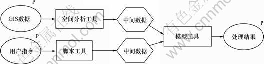
图1 地理处理建模示例
Fig.1 Geoprocess modeling
表1 GP工具类型
Table 1 Types of geoprocess tool

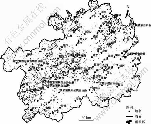
图2 贵州省历史滑坡灾害分布图
Fig.2 Landslide inventory map of Guizhou Province
控制和影响地质灾害孕育发生的主要影响因素可以归为3大类,即环境因素、诱发因素和历史因素[11]。本文选取高程、坡度、岩性和地质构造4个环境因素,年均降雨量和铁路建设2个诱发因素作为滑坡主要致灾因子(图3)。同一因子取值不同时对滑坡发生的影响程度不同,因此,需要将各一级因子进一步划分为若干二级因子。其中地质构造、铁路建设分别以到地质构造线距离和到铁路距离来划分二级因子。岩性等致灾因子作为地质变量,必须对其进行量化。由于各因子的测量单位不一致,导致每个因子的表现力不同,因此,还需要统一量纲。各因子分级标准、量化和量纲统一方法见文献[11]。分级后的致灾因子体系如图3所示。在因子属性表中使用对应的因子标识表示各二级因子地理区域,本文重点介绍基于该致灾体系的GP模型建立过程。
3 滑坡敏感性区划主客观权重方法
以基于专家评价和统计学的主客观权重方法[11] 为原型构建滑坡敏感性区划GP模型。首先,依据熵值理论,由二级因子历史滑坡灾害面积密度计算一级因子客观权重;然后,应用梯形模糊数方法(TFNW),由专家打分得到二级因子主观权重;最后,根据权重线性叠加(WLC)模型编制滑坡敏感性区划图。下面介绍该方法的主要计算原理,详细计算步骤和实例见文献[11]。
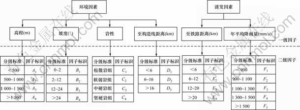
图3 滑坡致灾因子
Fig.3 Landslide causal factors
3.1 一级因子客观权重计算
根据熵值理论[12],某个一级因子的各个二级因子区域内历史滑坡灾害面积密度变化显著,则认为该一级因子对滑坡灾害的影响较大,即该因子权重较大。若某一级因子的所有二级因子的历史滑坡灾害面积密度变化很小,则认为该一级因子对滑坡灾害的影响较小,即该因子权重较小。一级因子权重计算过程如下。
由第i个一级因子的第j个二级因子的历史灾点面积ALij除以该二级因子覆盖的区域总面积ATij得到此二级因子的历史滑坡灾害密度dij(见式(1)),并对其进行归一化处理(见式(2))。
 ;i=1, 2, …, m;j=1, 2, …, n (1)
 ;i=1, 2, …, m;j=1, 2, …, n (2)
其中:n为一级因子包含的二级因子个数。根据pij求得一级因子熵值Hi(见式(3))。最后,依据式(4)计算一级因子的客观权重ωi。
 ;i=1, 2, …, m;j=1, 2, …, n (3)
 ;i=1, 2, …, m (4)
其中:m为一级因子个数,本文中取6; ,是一个常数,保证0≤Hi≤1。并规定:若pij=0,则ln(pij)=0。
3.2 二级因子主观权重计算
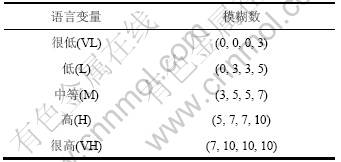
本文采用梯形模糊数方法,通过专家打分确定二级因子权重。首先,由决策者确定第t个专家权重Rt (专家总数为k);然后,由各专家依据事先设计好的语言评语集(见表2),以语言变量形式对二级因子的影响进行评价。根据式(5)和式(6)计算第i个一级因子第j个二级指标的模糊权重期望值 ;最后,依据式(7)进行归一化得到其二级因子主观权重
 。
。

 (5)
(5)
 ;
;
i=1, 2, …, m;j=1, 2, …, n (6)
 ;i=1, 2, …, m;j=1, 2, …, n (7)
其中:
 (8)
(8)
表2 语言变量和模糊数
Table 2 Linguistic variables and fuzzy numbers
3.3 综合权重及单元敏感性计算
根据权重线性组合模型(式(9))[13],由前述 和计算二级因子的主客观综合权重。
 ;i=1, 2, …, m;j=1, 2, …, n (9)
每一个地理单元的不同二级因子综合权重之和为敏感性分值。对于某地理单元k,其敏感性分值Sk按式(10)计算,依据该值和分级标准即可得到贵州省滑坡敏感性区划图。
 ;i=1, 2, …, m (10)
4 滑坡敏感性区划地理处理模型构建
4.1 模型工作空间
模型构建前先设计模型工作空间,用于分类存储输入/输出数据、临时文件和GP工具(图4)[14]。
其中,“临时文件”用于存储模型执行过程中的中间数据;“区域GIS数据库”包含一个Geodatabase数据库,用于存储和管理模型输入/输出数据;“滑坡敏感性区划工具箱”即GP模型工具箱,是本文GP服务的主体部分;“贵州省滑坡敏感性区划图”用于存储滑坡敏感性区划GP服务的成果。
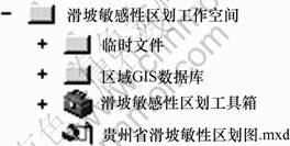
图4 模型空间目录
Fig.4 Space model directory
4.2 模型工具箱
模型工具箱包括3个模型工具集,共计14个GP工具,它们分别封装了部分地理处理功能,并组合成“滑坡敏感性区划总模型”(图5)。其中,“因子权重计算工具集”提供一级因子客观权重和二级因子主观权重的计算功能;“敏感性区划工具集”封装了滑坡敏感性区划图编制的4个主要步骤;“辅助脚本工具集”为其他工具/模型提供辅助功能。
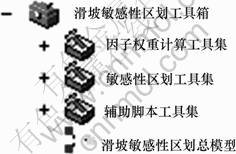
图5 模型工具箱结构
Fig.5 Kit structure of model
4.3 模型输入数据
模型输入数据包括致因子图层和二级因子专家评价信息,专家评价信息由客户端提交。模型所需的致灾因子图层如图6所示,其中:高程、坡度、岩性、至构造线距离、至铁路距离图层均来源于国家基础地理信息系统(NFGIS-M50DB);年平均降雨量图层来源于贵州省气象局;历史滑坡灾害分布图层来自贵州省国土资源厅多年调查和积累,并经实地考察补测得到。所有图层的比例尺都是1:500 000。
4.4 滑坡敏感性区划地理处理模型
4.4.1 滑坡敏感性区划总模型
滑坡敏感性区划总模型由数据预处理模型、一级因子权重计算模型、二级因子权重计算模型,敏感性分值计算与区划图编制模型4部分组成(图7)。数据预处理模型主要是标准化输入数据,如大地坐标系的统一。一级因子权重计算模型和二级因子权重计算模型分别封装了3.1节和3.2节的计算过程。敏感性分值计算与区划图编制模型是滑坡敏感性区划分析的中心模型,该模型综合致灾因子主、客观权重计算滑坡敏感性分值并编制滑坡敏感性区划图。
4.4.2 数据预处理模型
数据预处理模型旨在规范化因子图层,统一数据格式、空间参考系和分析范围,并将因子图层叠加,为敏感性分析做准备[15]。模型输入数据为图6所示的因子图层,输出数据为“因子叠加图层”。因子图层叠加过程就是属性表融合过程,融合后属性表中每一行对应一个二级因子组合区域(图8)。
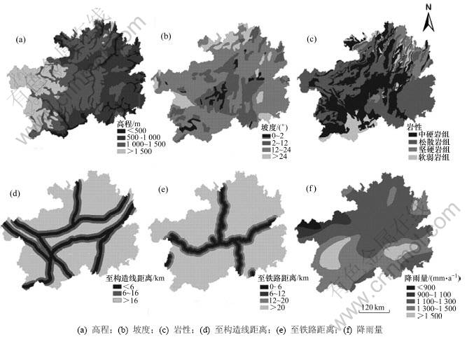
图6 因子图层
Fig.6 Factors’ layers
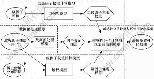
图7 滑坡敏感性区划总模型
Fig.7 General model for landslide-susceptibility mapping
4.4.3 一级因子客观权重计算模型
根据3.1节构建一级因子客观权重计算模型。该模型输入数据为每个致灾因子图层(图6)和滑坡灾害历史分布图层(图1),输出数据为一级因子客观权重。
以高程因子为列,其权重模型见图9。熵权模型的构建步骤为:(1) “区域因子分类”工具依据滑坡灾点历史分布图层,统计高程因子图层中各二级因子范围内历史滑坡的面积ALij和各二级因子所覆盖的区域面积ATij,由式(1)计算二级因子灾害密度dij,得到“因子灾害密度表”。(2) “密度归一化”工具调用脚本工具,由式(2)计算pij。(3) “熵值计算”工具获取pij并依据式(3)计算一级因子熵值Hi。 (4) “一级因子客观权重计算”工具依据一级因子熵值和式(4)计算一级因子客观权重。其他致灾因子熵权模型与之类似。
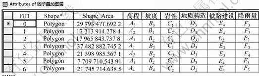
图8 因子叠加图层属性表
Fig.8 Attributes list of multi factors-overlay
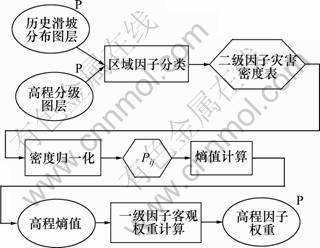
图9 一级因子客观权重模型
Fig.9 Weighting model for first level factor
4.4.4 二级因子主观权重计算模型
专家赋权界面由客户端负责, GP模型封装二级因子主观权重计算过程。根据3.2节构建二级因子主观权重模型,见图10。地质灾害专家通过互联网,在客户端用语言变量评价二级因子对滑坡灾害发生的影响,若影响大,则用高、很高进行评价。该模型首先依据表2,通过“语言变量转换”工具将语言变量翻译为模糊数;然后,根据式(5)和(6)计算二级因子模糊权重期望值 ;最后,由“权重归一化”工具计算二级因子主观权重。
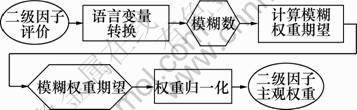
图10 二级因子主观权重模型
Fig.10 Weighting model for secondary level factor
4.4.5 敏感性分值计算与区划图编制模型
敏感性分值计算与区划图绘制模型可分为因子赋权、权重组合、计算敏感性分值、敏感性重分类4个步骤。前3个步骤是敏感性分值的计算,后1个步骤是敏感性区划图分级与绘制。
(1) “因子赋权”工具将主观权重和客观权重赋给因子图层属性表,如图11所示。它的输入数据为数据预处理模型、一级因子权重计算模型和二级因子权重计算模型的输出结果。“权重组合”根据式(9)计算二级因子的主客观综合权重,得到综合权重图层。
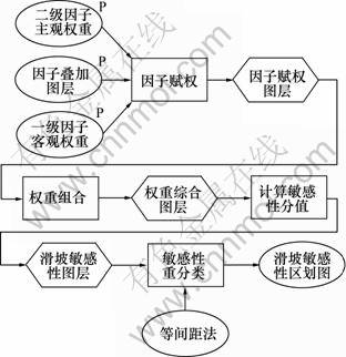
图11 敏感性分值计算与区划图绘制模型
Fig.11 The model of susceptibility score calculation and landslide-susceptibility mapping
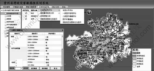
图12 贵州省滑坡灾害敏感性区划系统
Fig.12 Landslides susceptibility mapping system of Guizhou Province
(2) “计算敏感性分值”工具由式(10)累加同一地理单元内的二级因子综合权重(6列因子属性值相加),得到Sk。
(3) “敏感性重分类”工具采用等间距法,依据敏感性分值将贵州省划分为4个区域:极高危险区、高危险区、中等危险区和低危险区,模型执行完成后将滑坡敏感性区划图(图12)返回给客户端。
4.5 模型结果分析
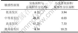
模型执行完成后,从Geodatabase数据库中调取滑坡敏感性区划图层与历史灾害图层进行叠加分析,计算得到各敏感级别分布面积百分比和该区内历史滑坡密度,如表3所示。从表3可以看出:随着易发性的增强,历史滑坡在该区分布的比例也增大,说明模型执行结果具有可靠性。
表3 滑坡敏感性区划图结果统计
Table 3 Results statistical for landslide-susceptibility mapping
5 滑坡敏感性区划系统
在ArcGIS Server平台下,开发滑坡敏感性区划系统,将贵州省境内滑坡的基础资料、因子致灾图层、气象信息、敏感性区划模型和灾害预警信息发布到互联网上。系统界面如图11所示。系统设定不同的使用权限,由防灾减灾有关人员(包括决策者、专业人士、相关人员)与GP服务进行交互,远程编制滑坡敏感性区划图。其他人员(如社会群众)可在互联网上获取最新的滑坡预测信息。专家因子评价界面见图12左下角。
6 结论
(1) 在ArcGIS的GP建模环境(ModelBuilder)下构建滑坡敏感性区划模型。该模型封装了GIS空间分析功能、主客观熵权模型和WLC模型,实现了滑坡敏感性区划图自动编制,减少了区划图编制的工作量。
(2) 通过ArcGIS Server Manager将GP模型发布为网络服务,实现了区划图编制的远程共享,一般地质灾害管理人员可能通过互联网由客户端调用GP服务为本地区编制滑坡敏感性区划图。
参考文献:
[1] 殷坤龙. 滑坡灾害预测预报[M]. 北京: 中国地质大学出版社, 2004.
YIN Kun-long. Landslide hazard prediction and evaluation[M]. Beijing: China University of Geosciences Press, 2004.
[2] 陈永坡. 滑坡危险度区划研究[D]. 成都: 西南交通大学土木工程学院, 2002: 4-21.
CHEN Yong-bo. Study on landslide hazard zonation[D]. Chengdu: Southwest Jiaotong University. School of Civil Engineering, 2002: 4-21.
[3] Lee S. Application of likelihood ratio and logistic regression models to landslide susceptibility mapping using GIS[J]. Environmental Management, 2004, 34(2): 223-232.
[4] 佟晶. 基于ArcGIS Server的地理处理服务应用研究[D]. 北京: 中国地质大学土地科学技术学院, 2010: 13-16.
DONG Jing. Research on geoprocessing service application based on ArcGIS Server[D]. Beijing: China University of Geosciences. School of Land Science and Technology, 2010: 13-16.
[5] Gtinther O, Miiller R. From GISystems to GIServices-Spatial computing on the interact marketplace[C]//Proceedings of the International Conference on Interoperating Geographic Information Systems. Santa Barbara. 1998:427-442.
[6] Open GIS Consortium Inc. Web service common implementation specification[EB/OL]. [2006-06-05]. http://www.opengeospatial. org/specs/?page:specs.
[7] Johannes B, Theodor F, Bastian S, Bastian B. Towards a research agenda for geoprocessing services[C]//12th AGILE International Conference on Geographic Information Science. Hannover: Leibniz Universit?t, 2009: 1-12.
[8] Lutz M. Ontology-based descriptions for semantic discovery and composition of geoprocessing services[J]. Geoinformatica, 2007, 11(1): 1-36.
[9] Fitzner D, Hoffmann J, Klien E. Functional description of geoprocessing services as conjunctive datalog queries[J]. Geoinformatica, 2011, 15(1): 191-221.
[10] Jimenez-Peralvarez J D, Irigaray C, Hamdouni R. Building models for automatic landslide-susceptibility analysis, mapping and validation in ArcGIS[J]. Nat Hazards, 2009, 50(3): 571-590.
[11] 王卫东. 基于GIS的区域公路地质灾害管理与空间决策支持系统研究[D]. 长沙: 中南大学商学院, 2009: 42-47.
WANG Wei-dong. Regional highway geological hazard management and spatial decision support system based on GIS[D]. Changsha: Central South University. Business School, 2009: 42-47.
[12] Shannon C E, Weaver W. The mathematical theory of communication[M]. Urbana: The University of Illinois Press, 1947: 3-19.
[13] Baban S M J, Van Yusof K. Modelling optimum sites for locating reservoirs in tropical environments[J]. Water Resources Management, 2003, 17(1): 1-17.
[14] Enviromental Systems Research Institute Inc. ArcGIS Desktop Help[EB/OL]. [2009-04-06]. http://webhelp.esri.com/ arcgisdesktop/9.3.
[15] Fitzner D, Hoffmann J, Klien E. Functional description of geoprocessing services as conjunction datalog queries[J]. Geoinformatica, 2011, 15(1): 191-221.
(编辑 陈灿华)
收稿日期:2010-02-20;修回日期:2010-04-28
基金项目:国家重点基础研究发展计划(“973”计划)项目(2011CB 710601);交通运输部科技项目(2009318000074);中央高校基本科研业务项目(2010DXPY016)
通信作者:王卫东(1971-),男,江西上饶人,博士,副教授,从事道路与铁道工程研究;电话:18673183460;E-mail: 147745@163.com

