Sedimentary system characteristics and depositional filling model of Upper Permian–Lower Triassic in South Yellow Sea Basin
来源期刊:中南大学学报(英文版)2018年第12期
论文作者:陈建文 袁勇 张银国 张玉玺 梁杰 张鹏辉
文章页码:2910 - 2928
Key words:sequence base-level cycle; sedimentary system; depositional filling model; Upper Permian–Lower Triassic; South Yellow Sea Basin
Abstract: In the South Yellow Sea Basin, Mesozoic–Paleozoic marine strata are generally well developed with large thickness, and no substantial breakthroughs have been made in hydrocarbon exploration. Through research, it is believed that the Upper Permian–Lower Triassic can be regarded as a long-term base-level cycle. Based on drilling data, characteristics of the lithology–electric property combination cyclicity, and the special lithology, the long-term base-level cycle was divided into five medium-term base-level cycles (MC1–MC5). On this basis, the Permian–Triassic sedimentary systems and their filling model were analyzed in accordance with the change of base-level cycle and transition of sedimentary environment, as well as characteristics of the drilling sedimentary facies and seismic facies. The results show that there were six sedimentary systems (fluvial, delta, tidal flat, open platform, restricted platform, and continental shelf) developed in the Upper Permian–Lower Triassic, the sedimentary systems were distributed such that the water was deep in the northwest and shallow in the southeast, and there were two base-level cycle filling models (a relatively stable tidal flat facies and a rapidly transgressive continental shelf facies to stable platform facies) developed in the Upper Permian–Lower Triassic. These models can provide a basis for evaluation of the Mesozoic–Paleozoic hydrocarbon geology in the South Yellow Sea Basin.
Cite this article as: YUAN Yong, CHEN Jian-wen, ZHANG Yin-guo, ZHANG Yu-xi, LIANG Jie, ZHANG Peng-hui. Sedimentary system characteristics and depositional filling model of the Upper Permian–Lower Triassic in the South Yellow Sea Basin [J]. Journal of Central South University, 2018, 25(12): 2910–2928. DOI: https://doi.org/10.1007/ s11771-018-3962-x.

J. Cent. South Univ. (2018) 25: 2910-2928
DOI: https://doi.org/10.1007/s11771-018-3962-x

YUAN Yong(袁勇)1, 2, CHEN Jian-wen(陈建文)1, 2, ZHANG Yin-guo(张银国)1, 2,ZHANG Yu-xi(张玉玺)3, LIANG Jie(梁杰)1, 2, ZHANG Peng-hui(张鹏辉)4
1. Key Laboratory of Marine Hydrocarbon Resources and Environmental Geology of Ministry of Land and Resources, Qingdao Institute of Marine Geology, Qingdao 266071, China;
2. Laboratory for Marine Mineral Resources, Qingdao National Laboratory for Marine Science and Technology, Qingdao 266071, China;
3. Faculty of Earth Resources, China University of Geosciences, Wuhan 430074, China;
4. College of Oceanography, Hohai University, Nanjing 210098, China
 Central South University Press and Springer-Verlag GmbH Germany, part of Springer Nature 2018
Abstract: In the South Yellow Sea Basin, Mesozoic–Paleozoic marine strata are generally well developed with large thickness, and no substantial breakthroughs have been made in hydrocarbon exploration. Through research, it is believed that the Upper Permian–Lower Triassic can be regarded as a long-term base-level cycle. Based on drilling data, characteristics of the lithology–electric property combination cyclicity, and the special lithology, the long-term base-level cycle was divided into five medium-term base-level cycles (MC1–MC5). On this basis, the Permian–Triassic sedimentary systems and their filling model were analyzed in accordance with the change of base-level cycle and transition of sedimentary environment, as well as characteristics of the drilling sedimentary facies and seismic facies. The results show that there were six sedimentary systems (fluvial, delta, tidal flat, open platform, restricted platform, and continental shelf) developed in the Upper Permian–Lower Triassic, the sedimentary systems were distributed such that the water was deep in the northwest and shallow in the southeast, and there were two base-level cycle filling models (a relatively stable tidal flat facies and a rapidly transgressive continental shelf facies to stable platform facies) developed in the Upper Permian–Lower Triassic. These models can provide a basis for evaluation of the Mesozoic–Paleozoic hydrocarbon geology in the South Yellow Sea Basin.
Key words: sequence base-level cycle; sedimentary system; depositional filling model; Upper Permian–Lower Triassic; South Yellow Sea Basin
Cite this article as: YUAN Yong, CHEN Jian-wen, ZHANG Yin-guo, ZHANG Yu-xi, LIANG Jie, ZHANG Peng-hui. Sedimentary system characteristics and depositional filling model of the Upper Permian–Lower Triassic in the South Yellow Sea Basin [J]. Journal of Central South University, 2018, 25(12): 2910–2928. DOI: https://doi.org/10.1007/ s11771-018-3962-x.
1 Introduction
Results from the analysis of regional geological, gravity, and magnetic data show that the South Yellow Sea Basin is not only an extension of the Yangtze plate in the sea area but also the main part of the lower Yangtze block [1, 2]. Although the South Yellow Sea Basin has undergone over 50 years of hydrocarbon exploration, with 29 wells in total drilled (23 in China and 6 in Korea) [2], industrial hydrocarbon flow has not yet been discovered [3–6]. In recent years, with the deepening investigation of hydrocarbon resources in the South Yellow Sea Basin, more and more research results have indicated that the Mesozoic– Paleozoic marine strata in the South Yellow Sea Basin have been developed completely and have large thickness; they share a similar sedimentary evolution history to that of the Sichuan Basin [1–3] and have the material base for formation of large hydrocarbon reservoirs, thus having high exploration potential for hydrocarbon resources [6–8]. At present, there is relatively little exploration in the South Yellow Sea Basin, and the seismic data mainly cover tectonic units such as the Yantai Depression, the Laoshan Uplift, the Qingdao Depression, and the Wunansha Uplift [9–11]. Previous research efforts on marine stratigraphic sequence sedimentation in the South Yellow Sea Basin provide only an overview of the seismic sequence division and sedimentary characteristics of the Upper Permian and the Lower Triassic [9–13], but an analysis of base-level sedimentary cycles and depositional filling models as understood from high-resolution sequence stratigraphy is lacking. The sedimentary facies of the marine strata in the South Yellow Sea have not been systematically studied, and this is an aspect with which numerous geologists have always been concerned [14, 15]. In this paper, based on the seismic sequence division by previous researchers, the base-level cycle characteristics and sedimentary system distribution laws of the Upper Permian Longtan Formation–Lower Triassic Qinglong Formation were analyzed mainly with the drilling data and the characteristics of seismic facies; corresponding depositional filling models are discussed to provide a scientific basis for further hydrocarbon exploration.
2 Geological overview
The South Yellow Sea is located in the eastern section of the Yangtze plate [1–5]. It connects the lower Yangtze northern Jiangsu Basin in the west, adjoins the Gyonggi block in the east, starts from the Qianliyan fault in the north, and reaches the Jiangshao fault in the south [2,6,15] (Figure 1). There are mainly three stages of sedimentary basins (platform, faulted, and depression) developed in the South Yellow Sea [2]. Very thick Mesozoic– Paleozoic marine strata were deposited in the platform basin (Figure 2); analysis of drilling and seismic data and sea–land comparison revealed that the South Yellow Sea Basin had similar sedimentary evolution and lithological association characteristics to those of the lower Yangtze land area in the Mesozoic–Paleozoic eras. Marine strata deposited in the South Yellow Sea Basin were relatively comprehensive and were kept relatively complete [1–3]. Neoproterozoic Sinian; Paleozoic Cambrian, Ordovician, Silurian, Devonian, Carboniferous, and Permian; and Mesozoic Triassic strata were deposited from the bottom up, with the Middle and Lower Devonian strata missing. There are currently seven wells encountering the marine Mesozoic–Paleozoic boundary during drilling, which mainly disclose the Permian and Lower Triassic Qinglong Formation, with the Middle and Upper Triassic strata missing. The Upper Permian Longtan–Dalong Formation and Lower Triassic Qinglong Formation are the target formations in this study (Figure 2). These are primarily distributed in the Qingdao Depression and the Wunansha Uplift in the plane and are missing in large areas in the Laoshan Uplift and the Yantai Depression.
3 Methods
3.1 Interpretation of seismic data
In recent years, through continuous research on key scientific problems, relatively high quality reflection data of the Mesozoic–Paleozoic have been obtained in the South Yellow Sea Basin (Figure 3). In this study, a whole-region structural interpretation was conducted with the newly collected seismic data.
The Upper Permian–Lower Triassic is located between T8 (the Indosinian structural plane) and T10 (the Hercynian structural plane) (Figure 3). The Permian Longtan Formation coal-bearing strata exhibited reflection characteristics of strong amplitude and high continuity. The Lower Triassic Qinglong Formation limestone exhibited an iconic blank reflection characteristic.
Both the T8–T9 (Lower Triassic) and T9–T10 (Upper Permian) reflected wave groups exhibited a medium–weak amplitude, noncontinuous–relatively continuous–continuous, medium–high frequency, parallel–relatively parallel internal reflection structure. Reflection with relatively strong amplitude was exhibited in the seismic profiles at places with coal-bearing strata developed, but the reflection amplitude varied with the thickness of the coal-bearing strata.
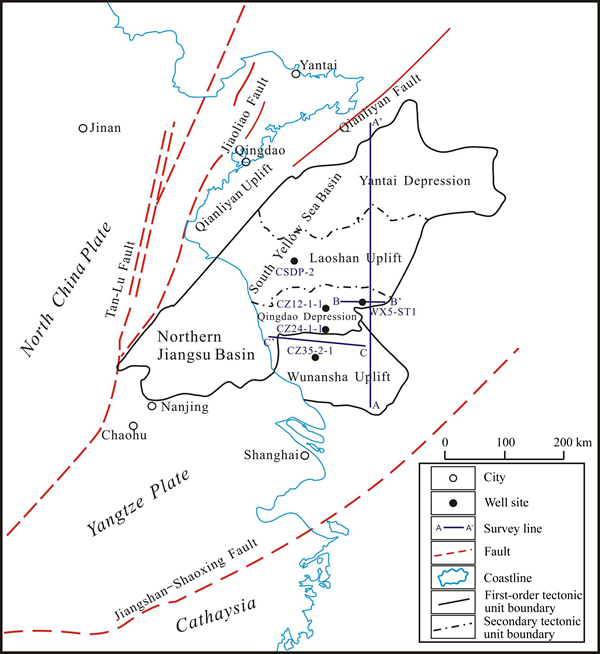
Figure 1 Regional location of South Yellow Sea Basin
3.2 Outcrop observation
The Mesozoic–Paleozoic marine strata in the South Yellow Sea Basin are relatively comparable to those in the lower Yangtze land area. Field geological investigation in the lower Yangtze land area is of important reference significance for studying the sedimentary characteristics at various times in the South Yellow Sea Basin.
The Longtan Formation of Qinglong Mountain, Nanjing, was dominated by gray to black mudstone, containing thin-layer coal streaks (Figure 4(a)). The bottom part of the Longtan Formation was yellow mud shale, enriched with fossils (ammonites, pelecypoda, etc.)(Figure 4(b)), and the middle and upper parts of the Longtan Formation had an increased sandy component.
The Upper Permian Dalong Formation of Pingdingshan Mountain, Chaohu, was dominated by black shale and thin-layer siliceous mudstone (Figure 4(c)). The Lower Triassic Yinkeng Formation was dominated by interbeds of gray shale, muddy limestone, and limestone(Figure 4(d)). The Upper Permian and the Lower Triassic had an evident boundary, which was a transition from deep-water continental shelf facies to shallow-water continental shelf facies (Figure 4(c)).
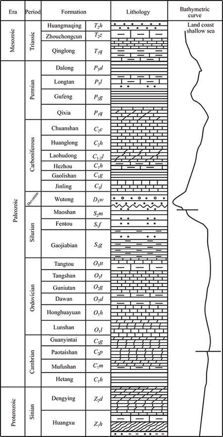
Figure 2 Histogram of marine Mesozoic and Paleozoic strata, South Yellow Sea Basin
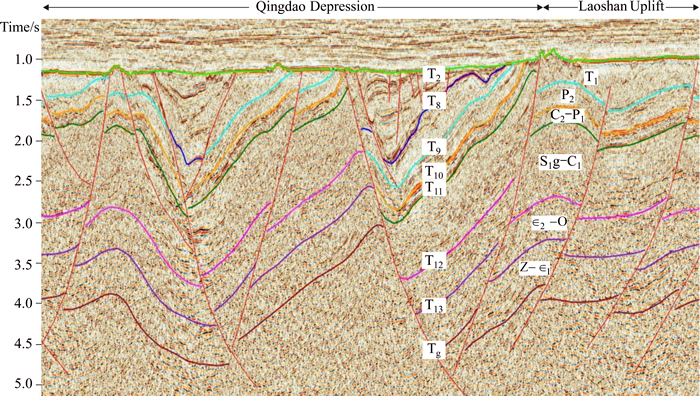
Figure 3 Seismic interpretation profile of Qingdao Depression and Laoshan Uplift from line A–A' (based on survey line marked on Figure 1)
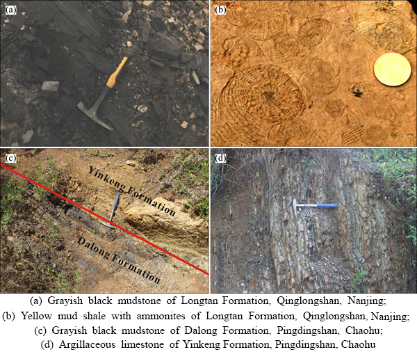
Figure 4 Outcrop photographs of Upper Permian–Lower Triassic strata:
3.3 Core description and logging analysis
Wells CZ35-2-1, WX5-ST1, and CSDP-2 in the South Yellow Sea Basin currently disclose relatively comprehensive Permian and Triassic strata; it can be seen from Wells CZ35-2-1 and CSDP-2 that there are strata missing in the upper part of the Qinglong Formation. The lithologic characteristics of the boundaries of the various strata and the boundaries of the various sequences were determined through core description of coring wells. The core sequences and sedimentary evolution sequences in the various coring wells were similar to the core sequences and sedimentary evolution sequences in the lower Yangtze land area.
Long-term base-level cycle division was conducted based on the characteristics of regional tectonic cycle change and sea-level change, using high- resolution sequence stratigraphic theory and base- level cycle recognition technology. Medium-term base-level cycle division was conducted based on the drilling data from the South Yellow Sea Basin and the characteristics of lithology–electric property combination cyclicity and the special lithology. The distribution characteristics of various sedimentary systems were analyzed based on both sedimentary facies in drilled wells and seismic facies, with an understanding of the results obtained in the lower Yangtze land area being fully taken into account.
4 Base-level cycle division
4.1 Long-term base-level cycle
During the Devonian–Triassic periods, the marine strata in the lower Yangtze region underwent two relatively large scale marine regressions and one large-scale marine transgression [2, 9–12]. At the late stage of the Early Permian, the Dongwu movement occurred, resulting in tectonic uplifting and finally causing the Gufeng Formation to be universally missed in the South Yellow Sea Basin and the Upper Permian Longtan Formation to directly cover the weathered crust (the Hercynian weathered crust) on top of the Lower Permian Qixia Formation (Figure 5). There was evident slurry seepage corresponding horizons during drilling. In the Late Permian Dalong period, large-scale marine transgression occurred [16–18]. During the Middle and Late Triassic, uplift of the Indosinian movement caused the Middle and Upper Triassic strata in the South Yellow Sea Basin to be missed in a large area, and the upper part of the Lower Triassic Qinglong Formation was denuded to a certain extent (Figure 5), finally forming the Indosinian weathered crust. The Indosinian weathered crust (Well CSDP-2) was dense earth-yellow, light gray, and gray limestone and was seriously weathered and easily broken (Figure 6(a)). In Well CZ35-2-1, the Hercynian weathered crust was relatively thin. In Well CSDP-2, the Hercynian weathered crust was not conspicuous, but the boundary between the Longtan Formation (carbonaceous shale) and the Lower Permian (siliceous mudstone and muddy limestone) was conspicuous (Figure 6(c)).
Based on the regional tectonic cycles, sea-level changes, and sedimentary characteristics, the Upper Permian–Lower Triassic (P2–T1) target stratum was regarded as a long-term base-level sedimentary cycle (LC1), with the top of the Dalong Formation as the maximum marine flooding surface (Figure 7) and the Hercynian weathered crust at the top of the Qixia Formation and the Indosinian weathered crust at the top of the Qinglong Formation as a sequence (Figure 7); LC1 had relatively strong asymmetry, and it entered a long-term base-level steady-decline half cycle after the largest scale marine transgression in the Late Permian.
4.2 Medium-term base-level cycles
4.2.1 MC1 medium-term cycle
This cycle had a set of littoral clastic rocks, mainly tidal flat facies and swamp facies sediments, developed on the Hercynian weathered crust. The cycle had relatively good symmetry. The lithology– electric property combination of the base-level rise half cycle had aggradation characteristics, and the base-level decline half cycle reflected a feature of relatively strong progradation in the marine regression period. The marine flooding surface mfs1 was an aggradation–progradation transitional surface and was located at the position with an amplitude starting to decline on the natural gamma- ray curve in terms of logging response; abrupt changes in amplitude of the well logging curve were mostly seen at the top and bottom of the cycle (Figure 5).
4.2.2 MC2 medium-term cycle
This cycle faced a relatively high speed, large- scale regional marine transgression in the Dalong period. The MC2 cycle had evident asymmetry: It was dominated by a stable base-level decline half cycle, and its natural gamma-ray curve exhibited a box shape as a whole, reflecting stable aggradation; the natural gamma-ray curve on the cycle top boundary transitioned from box shape to bell shape, indicating transition to marine transgression; the amplitude of the natural gamma-ray curve near the marine flooding surface mfs2 exhibited abrupt changes between high and low values (Figure 5). In Well CSDP-2, the part above the marine flooding surface (mfs2)(Figure 6(b)) was a large set of dark gray micritic limestone and red brown mudstone, and the part below mfs2 was dark gray fine–silty sandstone, gray black mudstone, and dark gray silty mudstone, sandwiched with thin coal seam.
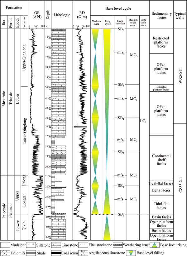
Figure 5 Composite histogram of Permian–Triassic base-level cycle, South Yellow Sea Basin [6]
The MC2 base-level rise half cycle was dominated by tidal flat sediments, and its lithology was mainly dark gray–gray black mudstone, followed by gray siltstone and gray fine sandstone. The MC2 decline half cycle was dominated by continental shelf sediments, and its lithology comprised interbeds of gray and dark gray limestone and dark gray and black mudstone with unequal thicknesses, sandwiching thin-layer argillaceous limestone and locally sandwiching thin-layer siltstone (Figure 5).
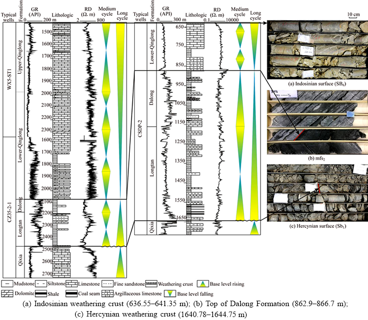
Figure 6 Permian–Triassic base-level cycle of Well CSDP-2 and core features of sequence boundary:
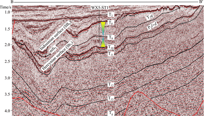
Figure 7 Seismic sequence characteristics of Permian–Triassic from line B–B' (based on survey line marked Figure 1)
4.2.3 MC3 medium-term cycle
A relatively large scale marine transgression occurred again after MC2. The MC3 cycle had some symmetry, and the marine flooding surface mfs3 exhibited characteristics of condensed section with relatively high natural gamma-ray counts and low resistivity. There were evident lithology–electric property combination characteristics of transition from retrogradation to progradation on the marine flooding surface (Figure 5).
The MC3 base-level rise half cycle and decline half cycle differed greatly with respect of sediments: the rise half cycle was dominated by continental shelf–open platform sediments, and its lithology was mainly interbeds of black mudstone, dark gray argillaceous limestone, and gray limestone; the decline half cycle was dominated by thick-layer gray limestone sediments, followed by dark gray and black mudstone, with thin-layer sandstone sandwiched locally, and with dolomite developed in the top of the cycle (Well WX5-ST1 area), and this is the sedimentary characteristic at the late stage of the base-level decline.
4.2.4 MC4 medium-term cycle
In the base-level rise period of the MC4 medium-term cycle, there were primarily open platform carbonate rock sediments in the cycle, and there were corresponding mudstone sediments near the marine flooding surface mfs4. At the late stage of the base-level decline half cycle, the limestone and sandy mudstone mostly exhibited interbeds (Figure 5), reflecting relatively strong terrigenous clastic sediments during sea-level decline.
4.2.5 MC5 medium-term cycle
In the base-level rise period of the MC5 medium-term cycle, there were open platform thick-layer carbonate rock sediments in the cycle, and there were corresponding mudstone sediments near the marine flooding surface mfs5. In the base-level decline period, there were mostly interbeds of carbonate rock, sandstone, and mudstone.
5 Types and characteristics of sedimentary systems
In the Upper Permian Longtan Formation and Dalong Formation of the lower Yangtze land area, there were mainly fluvial facies, tidal flat facies, slope facies, continental shelf facies, and basin facies developed (Figures 4(a)–(c)) [19–21]. In the Triassic, there were primarily clastic rock platform facies, carbonate rock platform facies, slope facies, and continental shelf–basin facies developed (Figure 4(d)) [22–25]. Based on the stratigraphic characteristics disclosed by drilling in the South Yellow Sea, the authors studied the sedimentary facies with the sedimentary systems combined by dominant facies as research units and divided the target stratum into six major sedimentary systems fluvial, delta, tidal flat, restricted platform, open platform, and continental shelf. The Upper Permian Longtan Formation and Dalong Formation were dominated by clastic rock sediments, with fluvial, delta, and tidal flat sedimentary systems developed, and there were continental shelf sedimentary systems developed locally in the Dalong Formation. The Lower Triassic was dominated by carbonate rock sediments, followed by clastic rock sediments, and the sedimentary facies types mainly had restricted platform and open platform sedimentary system; the lower section of the Qinglong Formation in the drilled wells disclosed a continental shelf sedimentary system, which, however, was not regarded as the dominant facies in the whole Qinglong Formation, owing to thin development and limited distribution.
5.1 Fluvial
The fluvial sedimentary system was not disclosed in the drilled wells, and it mainly corresponded to parallel–subparallel, weak– medium–moderately strong amplitude, low- frequency, intermittent–relatively continuous seismic reflection based on the seismic reflection characteristics.
5.2 Delta
The delta sedimentary system was primarily seen in the Longtan Formation through Wells WX5-ST1, CZ35-2-1, and CSDP-2. There were mainly a delta plain and a delta front developed in the delta sedimentary system [26], with swamp coal seam, peat, and fluvial sandstone developed in the delta plain (Figure 8(a)) and underwater distributary channel, mouth bar, and interdistributary bay developed in the delta front. The lithology of the distributary channel was mainly fine sandstone and siltstone, and the well logging curve exhibited box and bell shapes (Figures 9(a) and (b)). The lithology of the mouth bar was mainly fine sandstone, and siltstone, and the well logging curve exhibited a funnel shape. The lithology of the interdistributary bay was mainly argillaceous rock, sandwiching thin layer sandstone, and the well logging curve exhibited a tooth or finger shape. The delta sedimentary system was seismically dominated by progradational reflection characteristics.
5.3 Tidal flat
The tidal flat sedimentary system was relatively developed in the Longtan Formation and the Dalong Formation. This sedimentary system was characterized by nearshore swamp coal seam and carbonaceous mudstone (Figure 9(c)), which was dominated by argillaceous sediments, sandwiching thin-layer sandstone or argillaceous limestone, and the well logging curve was relatively toothed or straight (Figure 8(a)). The sand layer was dominated by tidal channel sediments, and the well logging curve exhibited characteristics of abrupt changes in the top and bottom. The tidal flat sedimentary system was seismically dominated by medium–low frequency, moderately strong amplitude, relatively continuous–continuous seismic reflection characteristics.
5.4 Restricted platform
The restricted platform sedimentary system was mainly seen in local intervals of the Triassic Qinglong Formation. It was dominated by mixed flat subfacies sediments, and its lithology was primarily interbeds of earth yellow and gray limestone (Figure 9(d)) and argillaceous limestone, sandwiching gray yellow mudstone and argillaceous siltstone, and interbeds of light gray thin-layer limestone and dark gray thin-layer limestone, sandwiching dolomitic limestone, with argillaceous limestone and calcareous argillaceous shale sandwiched between different layers in the bottom and with glauconite occasionally seen. The natural gamma-ray curve was relatively straight and slightly toothed, and the resistivity curve exhibited a sawtooth and finger shape and a local box shape.
5.5 Open platform
The open platform sedimentary system was seen in the Lower Triassic Qinglong Formation and was dominated by carbonate rock sediments, and there were primarily open platform and platform basin facies developed in the South Yellow Sea. The natural gamma-ray curve of the open platform was basically a relatively straight curve with low values and exhibited box shape characteristics (Figure 8(b)). There were mainly dark gray–black mudstone, carbonaceous mudstone, marlstone, and shale deposited in the platform basin facies.
The Qinglong Formation was further divided into the Upper Qinglong Formation (T1sq) and the Lower Qinglong Formation (T1xq). There were five wells in total that encountered the Qinglong Formation during drilling in the South Yellow Sea. The formation was dominated by open platform sediments, and the open platform was thick-bedded limestone, sandwiching thin-layer dark gray mudstone; the limestone had fine-crystalline and microcrystalline structures. As represented by Wells CZ35-2-1 and WX5-ST1, the natural gamma-ray curves were relatively straight and slightly toothed, and they mostly exhibited a box shape, and the resistivity curves had a reverse rhythm characteristic with a funnel shape, reflecting a hydrodynamic force turning from weak to strong. In Well WX5-ST1, there was a restricted platform developed locally, which consisted of interbeds of marlstone and mudstone or of thin-layer limestone, sandwiching siltstone locally.
5.6 Continental shelf
The continental shelf sedimentary system was located between the platform area and the basin area, the sedimentary interface was generally above the oxidized interface and under the normal wave bottom surface and in a subtidal low-energy environment, and the sediments were basically dominated by carbonate rock and mudstone, with organisms developed. Based on the water depth, the sedimentary system could be divided into shallow-water continental shelf and deep-water continental shelf. The continental shelf sedimentary system was mainly seen in the strata from the upper part of the Permian Dalong Formation to the lower part of the Triassic Lower Qinglong Formation in Well CZ35-2-1 (Figure 8(c)). The shallow-water continental shelf was dominated by thin-layer limestone and thin interbeds of marlstone and mudstone, with relatively dark color; the deep-water continental shelf was dominated by dark gray–gray black argillaceous shale, sandwiching thin-layer marlstone locally. There were continental shelf facies sedimentary outcrops seen from the terrestrial Permian Dalong Formation and Triassic Qinglong Formation in the lower Yangtze region. The lithology of the Dalong Formation continental shelf facies was dominated by shale, sandwiching siliceous belts (Figure 4(c)); the lithology of the Qinglong Formation continental shelf facies was dominated by microcrystalline limestone and argillaceous limestone, sandwiching calcirudite and quasi-nodular limestone, with mudstone in the bottom, of gray–dark gray in color and with thin- layer, lamellar structures developed (Figure 4(d)).
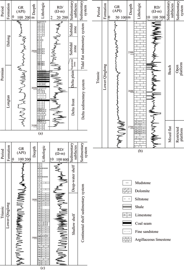
Figure 8 Lithology and electric properties of sedimentary system in South Yellow Sea Basin of delta sedimentary system of the Longtan Formation and tidal flat sedimentary system of the Dalong Formation from Well WX5-ST1 (2815–3108 m) (a), open platform and restricted platform sedimentary system of the Qinglong Formation from Well WX5-ST1(2410–2752 m)(b), continental shelf sedimentary system of lower Qinglong Formation from Well CZ35-2-1 (1700–1970 m)(c)
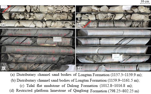
Figure 9 Core photographs of Permian–Triassic strata from Well CSDP-2:
6 Distribution of sedimentary systems
Different sedimentary systems have different seismic responses [11]. The corresponding relations of the sedimentary systems of the Permian Longtan Formation and Dalong Formation and the Triassic Qinglong Formation with the seismic facies were determined on the basis of analysis of the logging sedimentary systems and analysis of the seismic facies (Table 1). The distribution range of the sedimentary systems was delimited based on the sedimentary system characteristics and seismic reflection characteristics in the drilled well. On the whole, the distribution of the sedimentary systems of the Permian Longtan Formation and Dalong Formation and the Triassic Qinglong Formation had a characteristic of horizontal regular change (Figure 10).
6.1 Longtan formation
The distribution of the Longtan Formation in the South Yellow Sea varied in the south–north direction, the residual stratum was distributed relatively widely in the south, and the stratum was relatively limited in the north and mainly remained in faulted deep depressions. The sedimentary characteristics in the lower Yangtze land area showed that the whole Upper Paleozoic had a sedimentary pattern: shallow in the south and deep in the north, and there were basin facies, continental shelf facies, and coastal facies developed in turn from north to south in the Permian Dalong Formation [27, 28]. The Binhai Uplift was next to the Laoshan Uplift and the Qingdao Depression, and there was thick-layer sandstone, sandwiching mudstone and claystone, developed in the Longtan Formation. Based on the sedimentary characteristics of strata disclosed by the drilled wells and the seismic facies characteristics, it was believed through sea-land comparison that there were primarily tidal flat and fluvial sedimentary systems developed in the Longtan Formation of the South Yellow Sea, followed by a delta sedimentary system. The seismic reflection characteristic of the tidal flat sedimentary system was mainly parallel–subparallel, moderately strong–strong amplitude,low-medium frequency, relatively continuous– intermittent reflection (Table 1). Based on the data disclosed by the drilled wells, the delta sedimentary system primarily exhibited interbeds of sandy mudstone, sandwiching multiple sets of coal seams, and the tidal flat sedimentary system was mainly partial to argillaceous sediments, with tidal channel sandstone locally deposited; the seismic reflection characteristic of the fluvial sedimentary system was mainly parallel–subparallel, weak–medium amplitude, medium-frequency, intermittent reflection. Two drilled wells in the south of the South Yellow Sea disclosed that the delta sedimentary system of the Longtan Formation had sandstone relatively developed, with coal seams developed in the middle and upper parts, and seismically exhibited a progradational reflection characteristic. The sedimentary systems in the Longtan Formation of the South Yellow Sea exhibited a distribution law (Figure 10(a)) in which there were a fluvial sedimentary system in the southeast of and a tidal flat sedimentary system in the northwest of the Qingdao Depression, a delta sedimentary system in the Well CZ35-2-1 and Well WX5-ST1 areas, and a mainly tidal flat sedimentary system in the Yantai Depression (Figure 10(a)).
Table 1 Types of seismic facies, seismic reflection characteristics and their sedimentary significance of Longtan, Dalong and Qinglong Formation
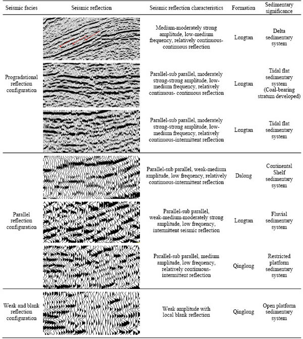
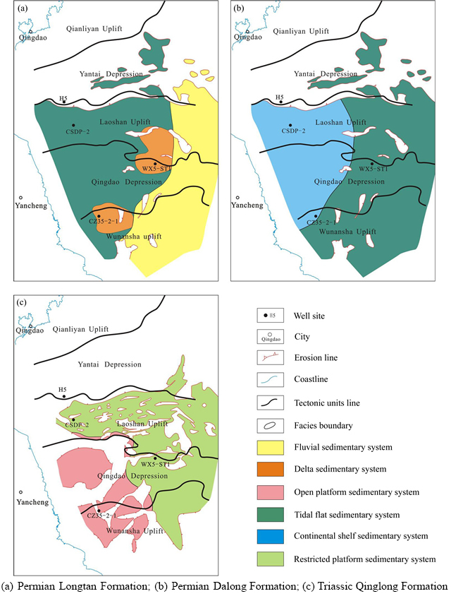
Figure 10 Sedimentary system distribution in South Yellow Sea Basin:
6.2 Dalong formation
There was mainly a large set of dark gray–black argillaceous shale developed in the Permian Dalong Formation, with interbeds of sandy mudstone developed partially. The water was deepened evidently in the Dalong Formation sedimentary period, compared with the Longtan Formation sedimentary period, and there were siliceous rock and shale developed locally in the Dalong Formation of the adjacent Binhai Uplift area in the west of the South Yellow Sea, indicating that a relatively large scale marine transgression occurred in local intervals of the Dalong Formation, forming deep-water continental shelf sediments [9]. Based on the data from the drilled wells and the seismic reflection characteristics in the South Yellow Sea, there were primarily continental shelf and tidal flat sedimentary systems deposited in the Permian Dalong Formation, and the water depth pattern of the Permian Dalong Formation inherited the characteristic of the Longtan Formation: deep water in the northwest and shallow water in the southeast, with continental shelf and tidal flat sedimentary systems distributed in turn (Figure 10(b)). The seismic characteristic of the continental shelf sedimentary system was parallel–subparallel, weak–medium amplitude, low-frequency, relatively continuous–intermittent reflection, and the sedimentary system was dominated by argillaceous shale sediments(Table 1).
6.3 Qinglong formation
The distribution characteristics of the Qinglong Formation in the South Yellow Sea were similar to those of the Longtan Formation and the Dalong Formation, varying in the north–south direction; the residual stratum was distributed relatively widely in the south, and the stratum was relatively limited in the north and mainly remained in faulted deep depressions. The seismic reflection was relatively weak as a whole, reflecting platform facies sediments dominated by carbonate rock. The Triassic Qinglong Formation in the South Yellow Sea similarly had sedimentary facies characteristics comparable to those in the lower Yangtze land area [12, 29], and there were mainly open platform and restricted platform sedimentary systems developed in the formation. The seismic reflection characteristics of the open platform sedimentary system were dominated by weak reflection, with local blank reflection, and the seismic reflection characteristics of the restricted platform sedimentary system were dominated by parallel– subparallel, medium-amplitude, low-frequency, relatively continuous–intermittent reflection (Table 1). The sedimentary pattern with deep water in the northwest and shallow water in the southeast was extended to the Triassic Qinglong Formation, and there were open platform and restricted platform sedimentary systems developed in turn from the northwest to the southeast in the formation (Figure 10(c)). In the lower interval of the Lower Qinglong Formation in Well N5 in the lower Yangtze land area and in Well CZ35-2-1 in the South Yellow Sea, there were continental shelf sediments developed, which had relatively small thickness, generally 300–500 m, and which were dominated by interbeds of gray–dark gray limestone and mudstone with unequal thicknesses, sandwiching marlstone and limy mudstone. The sediments gradually transitioned to a limestone layer, sandwiching siltstone, eastward to Well WX5-ST1, reflecting the change of facies belt: a transition from continental shelf facies to open platform facies to restricted platform facies. The eastern part was evidently influenced by terrigenous clastic rock, forming interbeds of sandy mudstone and limestone. However, the overall dominant facies of the Triassic in the South Yellow Sea was carbonate rock platform facies.
7 Depositional filling model
7.1 Relatively stable tidal flat facies filling model
After undergoing tectonic uplifting by the Dongwu movement, the strata entered the MC1 medium-term base-level cycle. At the early stage of sedimentation of the Longtan Formation, marine transgression started to occur, depositing a set of littoral clastic rocks, dominated by tidal flat facies sediments (Figure 11(a)). At the late stage of sedimentation of the Longtan Formation, a large-scale marine regression occurred, depositing a set of coal-bearing strata, which had been disclosed in Wells CZ35-2-1, WX5-ST1, and CSDP-2. This set of coal-bearing strata could be regarded as source rocks of the Permian–Triassic in the South Yellow Sea Basin. The seawater in the sedimentary period of the Longtan Formation was deep in the northwest and shallow in the southeast, and the Longtan Formation of the Binhai Uplift regionally and mainly deposited a set of subtidal zone siltstone and fine sandstone; the well logging curve exhibited a box shape with abrupt changes in the top and bottom, reflecting a relatively strong tidal effect in a tidal flat high-energy environment.
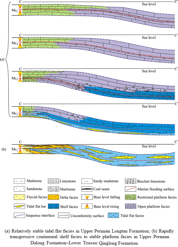
Figure 11 Depositional filling model of Upper Permian–Lower Triassic, South Yellow Sea Basin (with the section position marked on Figure 1):
7.2 Rapid marine-transgression-induced continental shelf facies–stable platform facies filling model
In the MC2 base-level rise half cycle, the scale of the marine transgression reached its maximum; in the lower Yangtze land area, there was continental shelf facies–basin facies siliceous argillaceous shale mostly seen in the Dalong Formation, whereas in the South Yellow Sea Basin, there was mainly black argillaceous shale. Vertically, there were tidal flat sediments in the lower part of the Dalong Formation and continental shelf facies black mudstone sediments in the upper part (Figure 11(b)). These organic-matter-enriched argillaceous shale and argillaceous limestone were favorable source rocks. After entering the Early Triassic, development of stable continental shelf facies argillaceous shale, thin-layer argillaceous limestone, and limestone began in the MC2 base- level decline half cycle.
In the MC3 base-level rise half cycle, a relatively large scale marine transgression occurred again, depositing a set of strata dominated by argillaceous rock; there were sediments of thin interbeds of tidal flat facies mudstone, argillaceous limestone, and limestone developed at the early stage of marine regression in the decline half cycle, and there was platform facies limestone developed at the middle and late stages (Figure 11(b)).
The MC4 and MC5 medium-term cycles were in the base-level decline period of the long-term base-level cycle (LC1), when there were relatively small-scale marine transgression and marine regression occurring, with open platform facies limestone sediments developed widely and restricted platform facies developed only in local areas of the east (Figure 11(b)). After being transformed by the Indosinian movement, the fracture limestone and the top weathered crust in this set of strata could become potential favorable reservoirs.
8 Conclusions
1) Based on the characteristics of regional tectonic cycle change and sea-level change, the Upper Permian–Lower Triassic in the South Yellow Sea Basin could be regarded as a long-term base-level cycle, which had relatively strong asymmetry, with a relatively short base-level rise period when the marine transgression was rapid and the deposited strata were relatively thin and with a relatively slow and stable base-level decline period when the deposited strata were relatively thick. Based on the lithology–electric property combination cycle characteristics and special lithology in the drilled wells of the basin, the long-term base-level cycle was divided into five medium-term base-level cycles (MC1–MC5), which had relatively strong comparability in the horizontal direction.
2) Based on the sedimentary setting in the lower Yangtze land area and the drilling data and seismic reflection characteristics in the South Yellow Sea, there were mainly six major sedimentary systems (fluvial, delta, tidal flat, open platform, restricted platform, and continental shelf) developed in the Upper Permian Longtan Formation–Lower Triassic Qinglong Formation. The Upper Permian Longtan Formation and Dalong Formation to the Lower Triassic Qinglong Formation had a similar sedimentary distribution pattern to that in the lower Yangtze land area, which was deep water in the northwest and shallow water in the southeast, and vertically they exhibited a transgression–regression–transgression–regressionsedimentary cycle.
3) Based on the change of base-level cycle and the transition of sedimentary environment, there were two base-level cycle filling models developed in the Upper Permian–Lower Triassic: the relatively stable tidal flat facies in the Upper Permian Longtan Formation and the rapid marine- transgression-induced continental shelf facies to stable platform facies in the Upper Permian Dalong Formation–Lower Triassic Qinglong Formation.
References
[1] LIANG Jie, ZHANG Peng-hui, CHEN Jian-wen, GONG Jian-ming, YUAN Yong. Hydrocarbon preservation conditions in Mesozoic–Paleozoic marine strata in the South Yellow Sea Basin [J]. Natural Gas Industry, 2017, 37(5): 10–19. DOI: 10.3787/j.issn.1000-0976.2017.05.002. (in Chinese)
[2] ZHANG Yin-guo, LIANG Jie. Sedimentary system characteristics and their sedimentary evolution from the permian to triassic in the Southern Yellow Sea Basin [J]. Journal of Jilin University, 2014, 44(5): 1406–1418. DOI: 10.13278/j.cnki.jjuese.201405102. (in Chinese)
[3] LI Wen-yong, LIU Yan-xu, LI Bin, LUO Feng. Hydrocarbon Exploration in the South Yellow Sea Based on Airborne Gravity, China [J]. Journal of Earth Science, 2016, 27(4): 686–698. DOI: 10.1007/s12583-015-0607-y.
[4] YUAN Yong, CHEN Jian-wen, LIANG Jie, ZHANG Peng-hui. Source-reservoir-seal assemblage of marine Mesozoic-Paleozoic in South Yellow Sea Basin by land-ocean comparison [J]. Petroleum Geology & Experiment, 2017, 39(2): 195–212. DOI: 10.11781/ sysydz201702195. (in Chinese)
[5] LIU Kai, LIU Huai-shan, WU Zhi-qiang, YUE Long. Seismic Acquisition parameters analysis for deep weak reflectors in the South Yellow Sea [J]. Journal of Ocean University of China, 2016, 15(5): 758–766. DOI: 10.1007/ s11802-016-2978-9.
[6] ZHANG Yin-guo, CHEN Qing-hua, CHEN Jian-wen. Upper permian-lower triassic base-level cycle and depositional filling model, South Yellow Sea [J]. Marine Origin Petroleum Geology, 2015, 20(3): 10–17. DOI: 10.3969/j.issn. 1672-9854.2015.03.002. (in Chinese)
[7] LI Nan, LI Wei-ran, LONG Hai-yan. Tectonic evolution of the north depression of the South Yellow Sea Basin since Late Cretaceous [J]. Journal of Ocean University of China, 2016, 15(6): 967–976. DOI: 10.1007/s11802-016-2843-x.
[8] ZHAO Wei-na, ZHANG Xun-hua, MENG Xiang-jun, WU Zhi-qiang, QI Jiang-hao, HAO Tian-yao, ZHENG Yan-peng, Liu Kai. S-wave velocity structures and Vp/Vs ratios beneath the South Yellow Sea from ocean bottom seismograph data [J]. Journal of Applied Geophysics, 2017, 139: 211–222. DOI: 10.1016/j.jappgeo.2017.02.015.
[9] WANG Ming-jian, ZHANG Xun-hua, WANG An-guo, XIAO Guo-lin, WANG Jiao. Depositional facies of Longtan and Dalong formations in the southern depression of South Yellow sea basin [J]. Marine Geology Frontiers, 2014, 30(7): 46–51. DOI:10.16028/j.1009-2722.2014.07.011. (in Chinese)
[10] LIN Nian-tian, GAO Deng-hui, SUN Jian, WEI Li-jie, PENG Jie. Seismic attributes of the Permian and Triassic in Qingdao depression, South Yellow Sea Basin and their geological significance [J]. Acta Petrolei Sinica, 2012, 33(6): 987–996. DOI: 10.7623/syxb201206009. (in Chinese)
[11] LEI Bao-hua, Chen Jian-wen, LI Gang, GONG Jian-ming, ZHANG Yin-guo, YANG Yan-qiu, WANG Jian-qiang. Seismic stratigraphic features and recognition of the Permian in the South Yellow sea basin [J]. Marine Geology Frontiers, 2016, 32(1): 29–35. DOI: 10.16028/j.1009-2722.2016.01005. (in Chinese)
[12] WANG Ming-jian, ZHANG Xun-hua, XIAO Guo-lin, WU Zhi-qiang, WANG Jiao, WANG An-guo. Tectonic evolution and hydrocarbon accumulation since Triassic of the southern depression in South Yellow Sea Basin [J]. Natural Gas Geoscience, 2014, 25(7): 991–998. DOI: 10.11764/j.issn. 1672-1926.2014.07.0991. (in Chinese)
[13] WU Shu-yu, LIU Jun, XIAO Guo-lin, ZHANG Yin-guo, ZHAO Tie-hu. Application of seismic attribute analysis to the Permian-Triassic deposits in the South Yellow sea [J]. Marine Geology & Quaternary Geology, 2011, 31(5): 109–116. DOI: 10.3724/SP.J.1140.2011.05109. (in Chinese)
[14] LI Wen-yong, LIU Yan-xu, XU Jian-chun. Onshore–offshore structure and hydrocarbon potential of the South Yellow Sea [J]. Journal of Asian Earth Sciences, 2014, 90(4): 127–136. DOI: 10.1016/j.jseaes.2014.04.024.
[15] LI San-zhong, JAHNA B, ZHAO Shu-juan, DAI Li-ming, LI Xi-yao, SUO Yan-hui, GUO Ling-li ,WANG Yong-ming, LIU Xiao-chun, LAN Hao-yuan, ZHOU Zai-zheng, ZHENG Qi-liang, WANG Peng-cheng. Triassic southeastward subduction of North China Block to South China Block: Insights from new geological, geophysical and geochemical data [J]. Earth-Science Reviews, 2017, 166: 270–285. DOI: 10.1016/j.earscirev.2017.01.009.
[16] LI Jian-hua, ZHAO Guo-chun, JOHNSTON S T, DONG Shu-wen, ZHANG Yue-qiao, XIN Yu-jia, WANG Wen-bao, SUN Han-shen, YU Ying-qi. Permo-Triassic structural evolution of the Shiwandashan and Youjiang structural belts, South China [J]. Journal of Structural Geology, 2017, 100: 24–44. DOI: 10.1016/j.jsg.2017.05.004.
[17] LIU Wei-fu, LIU Shuang-long, SUN Li-xin, BAI Wen-shuang, DING Zhen-kun, WANG Ze-yu. Neoproterozoic stratigraphic correlation of Subei-Huainan in China [J]. Journal of Central South University, 2016, 23(6): 1449–1458. DOI: 10.1007/s11771-016-3197-7.
[18] QIU Liang, YAN Dan-Ping, YANG Wen-Xin, WANG Ji-bin, TANG Xiang-li, ARISER S. Early to Middle Triassic sedimentary records in the Youjiang Basin, South China: Implications for Indosinian orogenesis [J]. Journal of Asian Earth Sciences, 2017, 141: 125–139. DOI: 10.1016/j.jseaes. 2016.09.020.
[19] FANG Qian, HONG Han-lie, CHEN Zhong-qiang, YU Jian-xin, WANG Chao-wen, YIN Ke, ZHAO Lu-lu, LIU Zhao, CHENG Feng, GONG Ni-na, HARALD F. Microbial proliferation coinciding with volcanism during the Permian-Triassic transition: New, direct evidence from volcanic ashes, South China [J]. Palaeogeography Palaeoclimatology Palaeoecology, 2017, 474: 164–186. DOI: 10.1016/j.palaeo.2016.06.026.
[20] HU Li-sha, CAWOOD P A, DU Yuan-sheng, XU Ya-jun, WANG Cheng-hao , WANG Zhi-wen, MA Qian-li, XU Xin-ran. Permo-Triassic detrital records of South China and implications for the Indosinian events in East Asia [J]. Palaeogeography Palaeoclimatology Palaeoecology, 2017, 485: 84–100. DOI: 10.1016/j.palaeo.2017.06.005.
[21] LAI Jin, WANG Gui-wen, FAN Zhuo-ying, CHEN Jing, WANG Shu-chen, FAN Xu-qiang. Sedimentary characterization of a braided delta using well logs: The Upper Triassic Xujiahe Formation in Central Sichuan Basin, China [J]. Journal of Petroleum Science & Engineering, 2017, 154: 172–193. DOI: /10.1016/j.petrol.2017.04.028.
[22] LEI Li-dan, SHEN Jun, LI Chao, ALGEO T J, CHEN Zhong-qiang, FENG Qing-lai, CHENG Meng, JIN Cheng-sheng, HUANG Jun-hua. Controls on regional marine redox evolution during Permian-Triassic transition in South China [J]. Palaeogeography Palaeoclimatology Palaeoecology, 2017, 486: 17–32. DOI: 10.1016/j.palaeo. 2017.02.010.
[23] DENG Bao-zhu, WANG Yong-biao, WOODS A, LI Sheng, LI Guo-shan, CHEN Wei-han. Evidence for rapid precipitation of calcium carbonate in South China at the beginning of Early Triassic [J]. Palaeogeography, Palaeoclimatology, Palaeoecology, 2017, 474(15): 187–197. DOI: 10.1016/j.palaeo.2016.06.007.
[24] LIU Chen-sheng, ZHANG Lin-ting, GUO Jian-hua, WANG Ming-yan. Application of sequence stratigraphy to Triassic terrestrial strata in Tahe area of Tarim Basin. [J]. Journal of Central South University, 2012, 19(5): 1388–1398. DOI: 10.1007/s11771-012-1155-6.
[25] ZHANG Li-Jun, BUATOIS L A, GABRIELAM NGANO M, QI Yong-an, ZHANG Xin, SUN Shang-qian, TAI Chao. Early Triassic estuarine depauperate Cruziana Ichnofacies from the Sichuan area of South China and its implications for the biotic recovery in brackish-water settings after the end-Permian mass extinction [J]. Palaeogeography, Palaeoclimatology, Palaeoecology. 2017, 485: 351–360. DOI: 10.1016/ j.palaeo.2017.06.025.
[26] ZHANG Yang, QIU Long-wei, YANG Bao-liang, LI Ji, WANG Ye-lei. Effects of water level fluctuation on sedimentary characteristics and reservoir architecture of a lake, river dominated delta [J]. Journal of Central South University, 2016, 23(11): 2958–2971. DOI: 10.1007/s11771- 016-3360-1.
[27] YAO Xu, ZHOU Yao-qi, HINNOV L A. Astronomical forcing of a Middle Permian chert sequence in Chaohu, South China [J]. Earth & Planetary Science Letters, 2015, 422: 206–221. DOI: 10.1016/j.epsl.2015.04.017.
[28] WU Si-qi, CHEN Zhong-Qiang, FANG Yu-heng, PEI Yu, YANG Hao, OGG J. A Permian-Triassic boundary microbialite deposit from the eastern Yangtze Platform (Jiangxi Province, South China): Geobiologic features, ecosystem composition and redox conditions [J]. Palaeogeography Palaeoclimatology Palaeoecology, 2017, 486: 58–73. DOI: 10.1016/j.palaeo.2017.05.015.
[29] WANG Ming-jian, ZHANG Xun-hua, WU Zhi-qiang, XIAO Guo-lin, WANG Jiao, WANG An-guo. Tectonic evolution of southern depression in the South Yellow Sea basin and its hydrocarbon accumulation in Permian [J]. Journal of China University of Mining & Technology, 2014, 43(2): 271–278. DOI: 10.13247/j.cnki.jcumt.2014.02.006. (in Chinese)
(Edited by HE Yun-bin)
中文导读
南黄海盆地上二叠统—下三叠统的沉积体系特征与沉积充填模式
摘要:南黄海盆地中—古生代海相地层发育齐全且厚度较大,一直未获得实质性的油气勘探突破。研究认为,南黄海盆地上二叠统—下三叠统可作为1个长期基准面旋回。基于南黄海盆地钻井资料,以岩电组合旋回性特征及特殊岩性为依据,将长期基准面旋回划分为5个中期基准面旋回(MC1-MC5)。在此基础上,依据基准面旋回变化和沉积环境的变迁,结合钻井沉积相及地震相特征,对南黄海盆地二叠系—三叠系的沉积体系及充填模式进行了分析。结果表明:南黄海盆地二叠系龙潭组、大隆组和三叠系青龙组发育6大沉积体系—河流沉积体系、三角洲沉积体系、潮坪沉积体系、开阔台地沉积体系、局限台地沉积体系、陆棚沉积体系;龙潭组、大隆组和青龙组沉积体系具有水体西北深、东南浅的分布特征;上二叠统—下三叠统发育两种基准面旋回充填模式,即上二叠统龙潭组相对稳定的潮坪相和上二叠统大隆组—下三叠统青龙组快速海侵的陆棚相至稳定的台地相,这些模式可为南黄海盆地中—古生界油气地质评价提供基础依据。
关键词:层序基准面旋回;沉积体系;沉积充填模式;上二叠统—下三叠统;南黄海盆地
Foundation item: Projects(41506080, 41702162) supported by the National Natural Science Foundation of China; Projects(DD20160152, DD20160147, GZH200800503) supported by China Geological Survey; Projects(XQ-2005-01, 2009GYXQ10) supported by China Ministry of Land and Resources; Project(201602004) supported by the Postdoctoral Innovation Foundation of Shandong Province, China
Received date: 2017-07-22; Accepted date: 2018-03-27
Corresponding author: CHEN Jian-wen, PhD, Professor; Tel: +86-13805322803; E-mail: jwchen2012@126.com

