���Ϳ�ɽ�ؿ���ά���ӻ�ģ�͵Ĺ���
�����£��½��꣬������
(���ϴ�ѧ ��Դ�밲ȫ����ѧԺ������ ��ɳ��410083)
ժ Ҫ��������ά�����µؿ���ά����ģ�͵Ĺ��������о������÷��β�ֵ�㷨���Ľ����е���λ����������ģ�ͣ���������TIN��ARTP����ά����ģ�ͣ����ö���������������淨ʵ�ֿ���ϵͳ����άʵ�彨ģ�������߿���η��ֱ�����ı���ģ�ͼ��ڲ�ģ�͡��о�������������øĽ����е���λ���������ϸ�ֹ��̵�ƽ���ԣ�ʹ������״�����ƣ����������Ӷ��淨����ʵ�֣���ģ�ٶȿ죬Ч���Ϻã��߿�ģ�����η����Ͽ����ھ�ȷ�������ı߽���̬���ڲ����ԡ�
�ؼ��ʣ��ؿ̣���ά��ģ�����ӻ�����ά����ģ�ͣ�����
��ͼ����ţ�TD672 ���ױ�ʶ�룺A ���±�ţ�1672-7207(2008)03-0423-06
3D visualization modeling on geological and mining engineering in
a large-sized mine
ZHOU Zhi-yong, CHEN Jian-hong, YANG Li-bing
(School of Resources and Safety Engineering, Central South University, Changsha 410083, China)
Abstract: 3D modeling for geological and mining engineering was studied under real 3D condition. Fractal interpolation 3D date algorithm, i.e., improved midpoint displacement method, was utilized to set up the terrain model. Based on TIN and ARTP, 3D data model was constituted. 3D entity model of development system was established by the method of placing the roadway section on the roof center line. Surface model and internal model of orebody were established by line-frame and block-section method, respectively. The results show that the improved midpoint displacement method can be used to improve the stationarity of subdivision process, and make the control of whole shape easy. The method in which the roadway section located in roof center line possesses some excellences such as easy realization, fast modeling and good modeling effect. The boundary configuration and internal model of orebody can be established accurately by using line-frame method with block-section method.
Key words: geological and mining engineering; 3D modeling; visualization; 3D data model; fractal
������ǿ���������зdz��ؼ��Ļ��ڣ�����Ʋ���������������ؽ��Ϳ�ɽЧ��������� ��[1]�����ԣ������Ƚ��ķ����ͼ��������п滮����Ʒdz���Ҫ����ͳ�Ŀ��������ֽ��ͼ�Ͻ��л�����Autocad���������и�����ƣ������ö�άͼ�α�ʾ��ά�ĵ���������ӵľ�Ͳ����ķֲ����ܲ�ֱ�ۣ��Ҹ�ʩ����Աȷ������ռ��ϵ����ȷʩ�������һ�������ѡ����ÿ�ɽ���в������ϼ��������ϣ�������ɽ�ؿ̵���ά���ӻ�ģ�ͣ�ֱ�۵�չʾ�����������ε�ò����������Ĺ�ϵ���DZȽ�����Ľ��������
�����о������ⷽ������˴����о���ȡ����һ���ɹ�������Ҳ����һЩ�����ԣ�ʵ��֤����������Щ�����ڴ��������²�����ʵ�ط�ӳ�ر�����ʵ��Ȼ��̬����Ϊ���������ģ�͵Ľ����ǻ���һЩ��ͳ�Ľ�ģ�����������淨�������ݷ��ȷ��Ϳ��������Ž��ҵ�[1]�������⽨ģ�����ͷ������������˿����ʵ�飻�����۵�[2]�����������ϵͳ(����Ԫ��Ϊ��㡢�ڵ㼰�������)�����������ʵ���������ģ��κռӪ��[3]����˻���������漰���������ߵ�C++�㷨���ӽ�ģЧ�����Կ������������ģ�Ͷ��������뻯�����ڿ��ٽ������Ϳ�ɽ�ĸ����������һ���ľ����ԡ����ƺ͵�[4-5]����������ݻ������棬������������ģ�ͣ�����ں����������õģ����ǣ�����ijЩ�����������Ǽ�����������ҪѰ���µļ����ֶΡ������Щ������������߶�����ά�����´��Ϳ�ɽ���ӵؿ���ά����ģ�͵Ŀ��ٹ������������о�������ij���Ϳ�ɽ����������������塢����������ε�ò����ά����ģ�ͣ���ֱ�۵�չʾ����֮��Ŀռ��ϵ�������Ƶ�ȷ�Ժͺ����ԣ���������ȷʩ����
1 ���ڷ��β�ֵ�㷨�ĵ��ν�ģ
����ģ��ʵ������һ����ά�������飬���ν�ģ���̾��Ǹ�����֪��������(���꼰���)��ÿһ������(����Ԫ��)���ĸ���1���̡߳�����Ŀǰ�������еĵ��ν�ģ��ֵ�㷨����Ӧ�ñ�������Թ��̼������ͣ�����Ҫ�����õ��Ľ��Ӧ��������⻬ƽ���������Dz�����ʵ�ط�ӳ�ر�����ʵ��Ȼ��̬�����ŷ��μ������۵ķ�չ�����ڷ�����������Ȼ�ر���ֵ���������ܵ����ǵ����ӡ�������ڷ���ά���ı����ֵ�㷨Ӧ�˶������粴�ɽ�Ծ��������Ҷ�˲������е�λ�Ʒ������������ӷ������������ۻ�����С���任��[6]��ʵ����������÷����㷨�õ��ĵ���ģ�Ͳ����ܹ���ʵ�ط�ӳԭ���ݵ��������������һ����ԽϺõ�����ԭʼ��Ȼ�ر��Ĵֲ�������ԣ���ʾ��ǿ�ı����ԡ�
1.1 �Ľ����е���λ��
���ѹ㷺���õġ��е���λ���������˼·�ǣ��Թ���������еݹ�ϸ�֣�ÿ��ϸ�ֲ������½��ĸ̳߳��������ڵ�߳̽��������ڲ�����⣬������1���ɷ�ά����ֵH�ͦ��Լ��ݹ���i���ɵ����λ��?i��
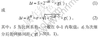
�е���λ�������㷨������ʵ�֣��������ڵ��α������������ۼ�����Ϊ�ˣ����һ�ָĽ��㷨������Լ���ġ��е���λ�����������ռ�����ĵݹ�ϸ���㷨����ͼ1��ʾ�����У�ͼ1(a)��ʾΪDEMԭʼ����(X��Y�ϵ�ƽ��ͼ)��ͼ1(b)��ʾΪϸ���ڲ������ϸ�ֺ��µ�������ĸ̷ֱ߳�ʽ(3)~(6)����[7]��
(a) ��k����(b) ��k+1��
ͼ1 �Ľ����е���λ��ʾ��ͼ
Fig.1 Sketch map of improved midpoint displacement method
���ڡ��������ϸ�֣�
���ڡ��������ϸ�֣�
���ڡ��������ϸ�֣�
���ڡ����ϸ�֣�
���У�G( )Ϊ��̬�ֲ��������������N(0, 1)��dΪDEM��(k+1)��ϸ�ֺ��������ľ��룻 Ϊ��㴦�ĸ����
1.2 ����ģ��
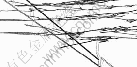
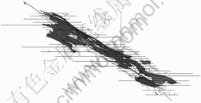
���������㷨�����˿�������ģ�ͣ���ͼ2��ʾ���ɼ�������ģ����ر�����ʵ��Ȼ��̬�dz��ӽ�����ʵ�ط�ӳ�˿������ε�������������������ݵ���(ͼ3)��������֤����ģ�͵�ȷ�ԡ�
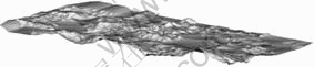
ͼ2 ����ģ��
Fig.2 Terrain model
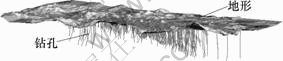
ͼ3 ���Ρ�������ͼ
Fig.3 Combined diagram of terrain and drill
2 ��ά����ģ��
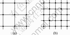
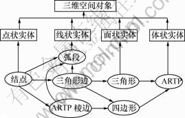
Ŀǰ������ά����ģ�͵��о���Ȼȡ����һЩ�ɹ�������Ȼ������ʵ��Ӧ����������Ҫ��������Щ�о����������Ϊ3DGIS�ṩһ��ͨ�õ�����ģ�ͣ����������˽���ij��רҵ���������ģ���о����Ӷ�����ģ������ʵ�֣����ƹ��Ӧ�á�����������£���ר��������ڲ�����������TIN����ֱ������(���ARTP)����ά����ģ��[2, 8]�����У�TIN�������ڱ���߽������Ϣ����ARTP�������ڽ��ռ�����ʷֳ�һϵ���ڽӵ����������Ԫ�ļ��ϣ������ռ������ڲ�������
2.1 ARTP��Ԫ�Ķ���
ARTP��3�����ߴ�ֱˮƽ�桢�����������治һ��ƽ�е���ֱ��������Ԫ(��ͼ4)�����У�A1��B1��C1��A2��B2��C2����һ��������ARTP��Ԫ����A1B1C1�͡�A2B2C2 ��ˮƽ���ͶӰ��Ϊ��A0B0C0�����⣬ARTP��Ԫ���п��ܳ�����A2��B2��C2��B1��A1��C2��A1��C1��B1������������״���ֱ���Կ�����2���3���غϵ����������
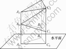
ͼ4��ARTP��Ԫʾ��ͼ
Fig.4 Sketch map of ARTP volume unit
2.2 ����TIN��ARTP����ά����ģ��
�ڻ���TIN��ARTP����ά����ģ��(ͼ5)�У����ؿ�ռ�������Ϊ��״ʵ�塢��״ʵ�塢��״ʵ�����״ʵ�塣��4�ֿռ����������ͨ����㡢���Ρ������αߡ�ARTP��ߡ������Ρ��ı��κ�ARTP��Ԫ��7�ֻ�������Ԫ��������[8]��
ͼ5������TIN��ARTP����ά����ģ��
Fig.5 3D data model based on TIN and ARTP
��״ʵ������ά�ռ���ɱ�ʾ��ά�ռ��� �ĵ�״��������ȡ���״ʵ���Ӧ�ڽ��Ԫ�أ����пռ�λ����Ϣ����x��y��z���ꡣ
��״ʵ����һά�ռ���ɱ�ʾ��ά�ռ��е���״�����ϲ��ߡ���ȣ�����1����������Ԫ����ɡ�������������ս���һϵ������㼯��ʾ��Ҳ���������αߺ�ARTP�����ɡ�
��״ʵ���Ƕ�ά�ռ���ɱ�ʾ��ά�ռ��е���״�����ز��桢�ϲ�ȣ���ʹ��TIN������ڼ�����̬���Dz�����ģ�����ά�ռ��е����档
��״ʵ������ά�ռ���ɱ�ʾ��ά�ռ��е���״��������������ȡ�����1����״ʵ��� �����ʷֳ�һϵ���ڽӵ��������ARTP��Ԫ�ļ��ϡ�������Ҫ���Ǹ�ʵ����ڲ���Ϣʱ�����Լ��ù��ɸ�ʵ��ı߽��������
3 ����ϵͳ��ģ
3.1 �������Ͳ����ά��ģ���㷨ʵ��
������ļ��ν�ģ�����У�������ֽ�Ϊ�㡢���Ρ�������桢�ֲ����4����ɲ��֡��������һϵ�еľֲ������ɣ��ֲ������������������κ��������������[9-10]�����������������ν�ģ�е���Ҫ��������Ҫ�й��Ρ����Ρ����Ρ�б���ε���̬(ͼ6)��Ϊ�˱��ڱ������������Ϊ�ϡ��¡�����4�����Σ�������������Ķ�����̬������ÿ����������һϵ�е���ɡ�
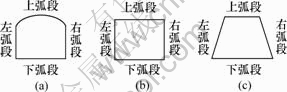
(a) ���ζ��棻(b) ���ζ��棻(c) ���ζ���
ͼ6 ����Ҫ���������̬ʾ��ͼ
Fig.6 Sketch maps of main laneway profile
���������ģ��ʱ���Ӷ�άͼ����ȡ������������ߺͶ�����������ݣ���1���������ߴ�������ֲ��䣬���������������ߺͶ���ͼ���������Ŀռ���̬(ͼ7)����������˼�룬��������㷨��
a. ���ݵ��߲������ݼ���άƽ��ͼֽȷ����������ߣ�
b. ���������ƽ��������
c. ȷ������������ݣ�
d. ����3ά���ʵ��ģ�͡�
ͼ7 ���ʵ��ģ��ʾ��ͼ
Fig.7 Sketch map of laneway entity model
3.2 ����ϵͳ��άʵ��ģ�͵Ĺ���
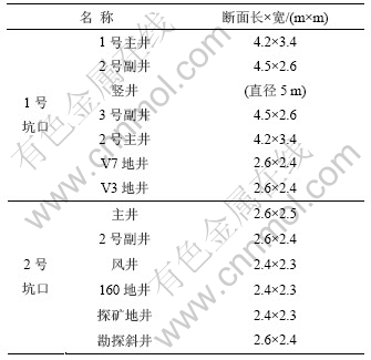
�ÿ�ɽ���ö��б�����أ����ڸ��־�Ͳ��������Ҹ��ӡ���ģ���ݸ���Ͳ�����������У�����1���˴ν�ģ�����ݰ������ֿ��ع��̣���ƽ�б�����������羮���ᆴ�ȡ���ģЧ����ͼ8~10��ʾ��
��1 ��Ͳ�������
Table 1 Profile standard of shaft
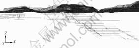
ͼ8 ����ϵͳ����ͶӰͼ(X-Z����)
Fig.8 Projection drawing of whole development system
(X-Z coordinate)
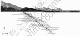
ͼ9 ����ϵͳ����ͶӰͼ(Y-Z����)
Fig.9 Projection drawing of whole development system
(Y-Z coordinate)
ͼ10 ����ϵͳ�ֲ�����ͼ
Fig.10 Stereogram of local development system
4 ���彨ģ
���ǵ����岻��������״����С���ռ�λ�õ���Ϣ�����Ҵ��ڿ���ɷ֡�������Ʒλ�����ԣ��� �ˣ������߿����������ģ�ͣ����ÿ�η���ֵ���������ڲ�ģ�͡������ȿ������߿�ģ����ȷ��ʶ�����ı߽���̬�����ֿ����������Ϣ���ֿ������ÿ��������Խ��в�ֵ�ķ���������������ڲ�ģ��[11-15]����2�ַ���ȡ�����̣��ɾ�ȷ�����ڱ���������ά��̬(ͼ11)��
ͼ11 V3����ʵ��ģ��
Fig.11 Entity model of V3 mine vein
4.1 �������ģ�͵Ľ���
�������ݵĻ�ȡ����ͨ����̽�õ��ģ�������ƿ�̽������ͼ����������ƽ�У�ÿһ������ʵ��Ľ�����ʵ���ڸ������ϵ������ߣ�����άƽ����һ����յ����Խ��ߡ���һϵ�������ϵ������������������γ����������������������������ı���ģ�͡�
4.2 �����ڲ�ģ�͵Ľ���
a. ȷ�����ģ����ķ�Χ���������ģ�͵���С������X��Y��Z��ƾ����6������ֵ��ȷ������Ĵ�С��λ�ã��ٷֱ����X��Y��Z����IJ�ֵ��ȡ������ߣ��Ա�֤�������ģ�Ͱ����ڸ���֮�ڡ�
b. �������ģ�͡�����������б���ģ���ϵ�һ��Ϊ��ʼ�㣬һ���ij���Ϊ�ⳤ���Ѹ���ֳ����ɸ��û�����ĵ�Ԫ�飬��ĸ����ӿ�ֱ��ţ����洢�����ݿ��С����ÿ�����ֵ��������ÿ����Ԫ������ԡ�
5 �� ��
a. �Ľ����е���λ����������������������ԣ��Ҿ�������������ӵ�Ч���������ϸ�ֹ��̵�ƽ���ԡ����ϲ��㴦�����û������������⻬������в�ֵ��ʹ������״�����ơ�
b. ����TIN������ģ�Ϳ����ڱ���߽������Ϣ����ARTP����ģ�Ϳ������ڽ��ռ�����ʷֳ�һϵ���ڽӵ����������Ԫ�ļ��ϣ������ռ������ڲ�������
c. �����Ͳ����ߴ�仯����ʱ���ɲ��ö��������Ӷ��淨�����������Ͳ��ʵ��ģ�͡�ʵ��֤�������ֽ�ģ��������ʵ�֣���ģ�ٶȿ죬Ч���á�
d. �����߿�ģ���ɾ�ȷʶ�����ı߽���̬�����ֿ����������Ϣ�����ÿ�η��ɶԿ��������Խ��в�ֵ������������ڲ�ģ�͡�����2�ַ������Ͽɾ�ȷ����������ά��̬��
�ο����ף�
[1] �Ž���, ������. ����������ʵ�����Ŀ滮�����[J]. �����ʱ��, 2005(3): 22-23.
ZHANG Jian-tao, FU Yong-ming. Planning and designing of mine based on virtual reality technique[J]. Computer Era, 2005(3): 22-23.
[2] ������, ������. ����ά�����ģ�������о�[J]. ���̿���, 2006(10): 46-49.
GE Yong-hui, WANG Jian-min. Study on the method of 3D laneway modeling[J]. Journal of Geotechnical Investigation & Surveying, 2006(10): 46-49.
[3] κռӪ, ����ɽ, ����Ԫ. �����������ά��ģ��C++ʵ��[J]. �人��ѧѧ��: ��Ϣ��ѧ��, 2005, 30(7): 60-62.
WEI Zhan-ying, WANG Bao-shan, LI Qing-yuan. Underground laneway modeling and realization by C++[J]. Geomatics and Information Science of Wuhan University, 2005, 30(7): 60-62.
[4] ���ƺ�, �Լ���, �����, ��. �ؿ�3άGISģ�͵Ĺ��������ӻ�[J]. �й���ҵ, 2003, 12(4): 60-62.
XU Yun-he, ZHAO Ji-xian, CHENG Peng-gen, et al. Construction and visualization of 3D GIS mine mode[J]. China Mining Magazine, 2003, 12(4): 60-62.
[5] �� ��, ������, �����, ��. ����������ݵĿ�����ά���ӻ��о���ʵ��[J]. ������ҵ��ѧѧ��, 2005, 27(4): 418-421.
LI Yan, WANG En-de, BAO Yu-bin, et al. Study and implementation of borehole data based 3D visualization of orebody[J]. Journal of Shenyang University of Technology, 2005, 27(4): 418-421.
[6] Ф����, ��Դ��. ���ڷ��μ��εĿռ��������η�����ά�ر���ֵ�е�Ӧ��[J]. �й�ͼ��ͼ��ѧ��, 2000, 5(3): 241-243.
XIAO Gao-yu, ZHOU Yuan-hua. Fractal-based special polyhedron model deformation algorithm in terrain surface interpolation[J]. Journal of Image and Graphics, 2000, 5(3): 241-243.
[7] �� ��. ������ά���ӻ�����[M]. ����: ��������, 2000.
XU Qing. Three dimension terrain[M]. Beijing: Sino Maps Press, 2000.
[8] ë�ƾ�, �� ΰ. ú�������ϵͳ��������Ƽ�����ʵ��[J]. ú̿ѧ��, 2005, 30(5): 571-575.
MAO Shan-jun, XIONG Wei. Design and primary implementation of coal mine virtual environment system[J]. Journal of China Coal Society, 2005, 30(5): 571-575.
[9] �� ΰ, ë�ƾ�, ������, ��. ú���������������ν�ģ���ؼ��㷨�о�[J]. ���ͨ��, 2002(8): 15-21.
XIONG Wei, MAO Shan-jun, MA Ai-nai, et al. A research on geometric modeling of roadway and the key algorithm of coalmine in virtual environment[J]. Bulletin of Surveying and Mapping, 2002(8): 15-21.
[10] ����ɽ, κռӪ. ú��������������ά��ģ�о�[J]. ���ѧԺѧ��, 2005, 22(3): 204-211.
WANG Bao-shan, WEI Zhan-ying. A research on three- dimensional modeling of roadway in virtual environment for coalmine[J]. Journal of Institute of Surveying and Mapping, 2005, 22(3): 204-211.
[11] ���Ǿ�, �� ÷, Ҧ����. ��ֱ�����չ�˲������彨ģ�о�[J]. ú̿��ѧ����, 2006, 34(8): 57-60.
LIU Ya-jing, LI Mei, YAO Ji-ming. Research on orebody model establishment with multi resolution ratio and extended octree[J]. Coal Science and Technology, 2006, 34(8): 57-60.
[12] ���, ����ѧ, ���ƺ�, ��. �ؿ���ά���ӻ�ϵͳ��ģ[J]. ������ɽ, 2005(12): 44-50.
LI Chun-min, LI Zhong-xue, WANG Yun-hai, et al. Visualization system modeling for geological and mining engineering[J]. Metal Mine, 2005(12): 44-50.
[13] ���Ƽ�, ������. �������ά�Զ���ģ�����о�[J]. �人��ѧѧ��: ��Ϣ��ѧ��, 2006, 31(12): 1097-1100.
WANG Yun-jia, FU Yong-ming. On 3D automatic modeling method of mine roadway[J]. Geomatics and Information Science of Wuhan University, 2006, 31(12): 1097-1100.
[14] ���ƽ, ����ѧ. �����ӻ����漼����ʵ��[J]. �����Ƽ���ѧѧ��, 2004, 26(6): 579-583.
LI Cui-ping, LI Zhong-xue. Volume visualization approach for modeling mineral deposits[J]. Journal of University of Science and Technology Beijing, 2004, 26(6): 579-583.
[15] ������, �� ��, �����. ������ά���ӻ���ģ����[J]. ������ѧѧ��: ��Ȼ��ѧ��, 2005, 26(9): 890-892.
WANG En-de, LI Yan, BAO Yu-bin. Visualized 3-D modeling of orebodies[J]. Journal of Northeastern University: Natural Science, 2005, 26(9): 890-892.
�ո����ڣ�2007-08-20�������ڣ�2007-10-18
������Ŀ��������Ȼ��ѧ����������Ŀ(50774092)��ȫ�����㲩ʿѧλ����ר���ʽ�������Ŀ(200449)�����ϴ�ѧ�������¹��̻�����Ŀ������Ŀ(1343-76230)
ͨ�����ߣ�������(1980- )���У����������ˣ���ʿ�о��������¿�ģ����ȫԤ�����ɿ���漰���ӻ������о����绰: 0731-8879889��E-mail: csuzzy@126.comx

